


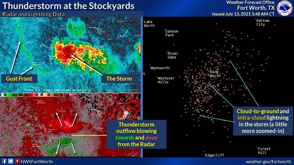
Nothing is showing up on radar this morning, but a few of you lucky ones saw some gully washers yesterday! Parts of Tarrant County measured over 2" of rain. You also experience very strong gusty winds. Believe it or not, there was also one severe thunderstorm warning for strong wind in Tarrant County during the late afternoon. There was also isolated wind damage in The Stockyards in FTW due to 60+ mph wind.

 NWS
NWS
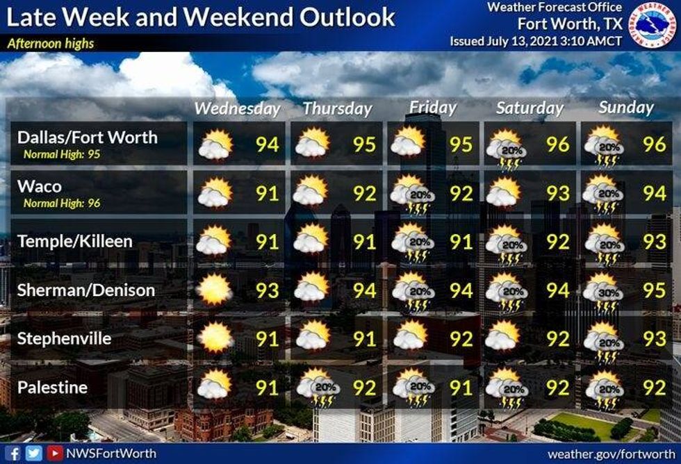
Rainfall chances virtually shut off over the next 6 days with only a slight chance for a late day storm today.
Temperatures are cool this morning for this time of the year, with readings near 70゚.
However, we'll have no trouble warming up into the middle nineties, not just today, but all the way through the upcoming weekend. Morning lows will be in the mid to upper seventies. At least the wind will pick up tomorrow from the south at 10-20mph through the period.
Something to look forward to… another RARE July cold front moves into the area early next week, increasing our rain chances and dropping our temperatures to near 90 for afternoon highs! Love it!
 NWS
NWS
7-Day Headlines:
* One or two Isolated late day showers and storms today.
* Faucet shuts off tomorrow through the weekend.
* Near average temperatures, mid 90s.
* Still no triple digit heat.
* Rain chance return NEXT week.
*Yest Rain: 0.00"; *Yest High: 91; Low: 73
*Today's Averages: High: 95; Low: 76
*Record high: 107 (1980); Record low: 64 (1990)
*July rain: 0.99"; July deficit:
*2021 Rain: 21.51"; 2021 surplus +0.15"
*Sunrise: 6:30am; Sunset: 8:38pm
Today: Mostly sunny and hot. An isolated late day shower or storm. High: Mid 90s. Wind: South 5-10 mph.
Tonight: Clear and muggy. Low: Mid 70s. Wind: South 10-20 mph.
Tomorrow: Mostly sunny, breezy and hot. High: Mid 90s. Wind: South 10-20 mph mph.
Thursday - Sunday: Partly cloudy, windy, hot and muggy. High: Mid 90s.
Monday: Partly cloudy and hot. Storm chances return.
High: Low 90s.
LISTEN on the Audacy App
Sign Up and Follow NewsRadio 1080 KRLD


