


We're waking up to seasonable temperatures with readings mainly in the 30s to low 40s. There's also some mid-level cloud cover streaming overhead.
We'll see these clouds thicken up throughout the day and especially this evening out and ahead of our next subtle weather maker. This system arrives Saturday into early Sunday. Afternoon highs will top out in the low 60s. Clouds will dominate overnight tonight with temperatures falling into the 40s.
Saturday looks to be cloudy through most of the day, with decreasing clouds by evening. There's a very slight chance of some light rain showers around the area, but unfortunately the strongest dynamics for measurable precipitation will be to our northwest where a compact snow storm will impact areas of northeastern New Mexico, southeastern Colorado, and western Kansas. This is where three to six inches of snow may fall.
 National Weather Service - Fort Worth
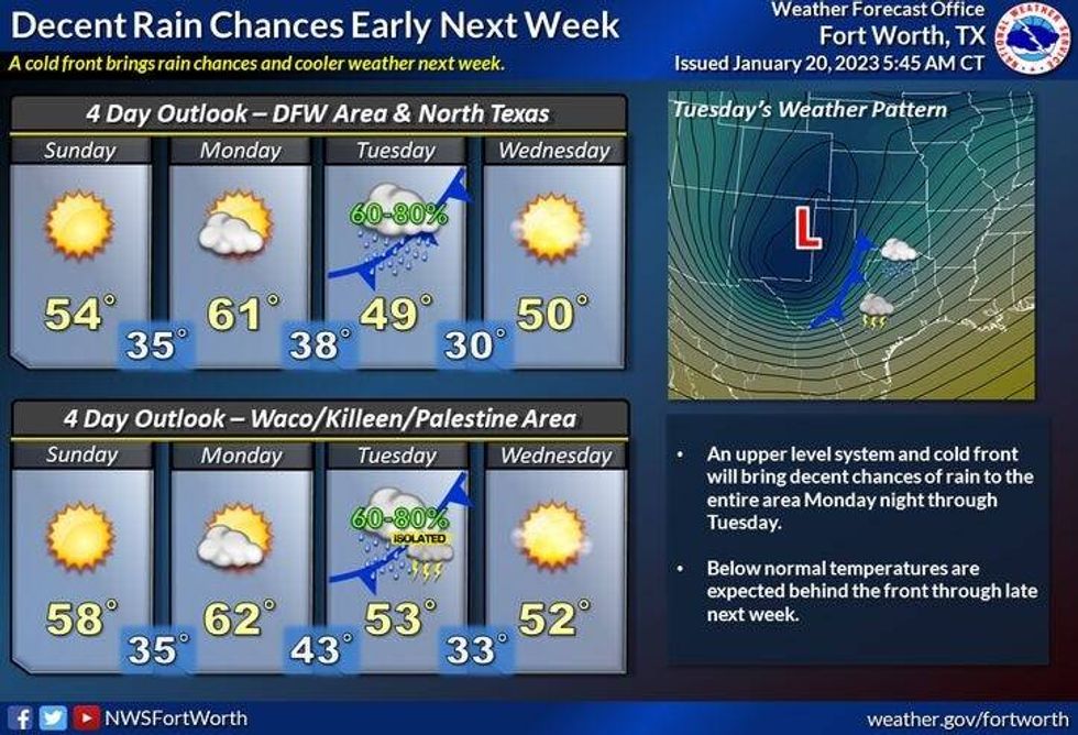
Sunday looks nice here, with plenty of sunshine, a gusty northerly wind and seasonal temperatures. Afternoon highs will reach the mid 50s, with the north wind gusting to 25 mph.
By Monday, clouds will increase again with high temperatures in the low 60s.
Our next weather maker arrives here late Monday into Tuesday, as a very dynamic storm system cruises across central and south Texas.. this track will be in a perfect position to give us a widespread chilly rain event. Great news!! It's been 31 days since DFW has measured anything greater than the trace of rain. Temperatures will hover in the 40s all day long and fall into the 30s by late afternoon as the system slowly exits to our east. There is a chance of a burst of wet snow NW of DFW late Tuesday, before ending Tuesday night. Could areas form Fort Worth -> West see a burst of snow before it all comes to an end? It's possible, but doubtful.. As of now, I am not concerned about any accumulations, but temperatures need to be watched at the surface. Road surface temperatures will be in the upper 40s to low 50s during this event, so travel will not be impacted if it even happens at all.
We're back to Sunshine on Wednesday and Thursday, but temperatures will remain cool. 40s on Wednesday, low 50s on Thursday. Also, a light freeze is expected both mornings.
*Yest Rain: Trace; High: 61; Low: 43
*Today's Averages: High: 57; Low: 36
*Record high: 83 (1986); Record low: 10 (1985)
*January rain: Trace; Deficit: 1.70"
*2023 rain: Trace; Deficit: 1.70"
*Sunrise: 7:29am; Sunset: 5:49pm
Today: Increasing clouds and cool. High: Low 60s. Wind: ESE 5-10 mph.
Tonight: Cloudy and cool. Low: Low to mid 40s. Wind: ESE 5-10 mph.
Saturday: Cloudy with a slight chance of showers. Then, decreasing clouds by evening. Staying cool. High: Low to mid 50s. Wind: SE 10 mph.
Sunday: Sunny, breezy and seasonable. High: Mid 50s.
Monday: Increasing clouds and cool. Slight chance of showers by late evening. High: Low 60s.
Tuesday: Cloudy and chilly. Decent chance of rain. High: Mid to upper 40s early, falling into the 30 by afternoon.
Wednesday: Sunny, windy and chilly. High: Mid to upper 40s.
Thursday: Sunny and cool. High: Low 50s.

LISTEN on the Audacy App
Tell your Smart Speaker to "PLAY 1080 KRLD"
Sign Up and Follow NewsRadio 1080 KRLD


