An active weather pattern will continue through the middle of next week with multiple rounds of showers and thunderstorms in the forecast. Keep in mind, it will not rain all day, every day, but periods of unsettled weather are expected. Please stay especially weather aware during the afternoon and early evening hours when daytime heating is at its peak.
Good morning and welcome to Thursday!
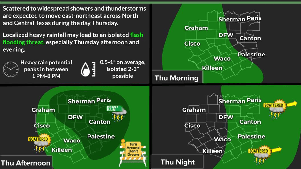
Keep your umbrella handy and your eyes on the road as we head through the afternoon and evening hours today. Numerous showers and thunderstorms are expected to develop ahead of an upper-level disturbance moving west to east across North Texas. The main threats with stronger storms will be small hail, frequent lightning, heavy rainfall, and gusty winds.
Not everyone will see storms today, but for areas that have received recent rainfall, the ground is already saturated. It will not take much additional rain to create localized flash flooding, especially near creeks, streams, and construction zones. Please use extra caution during the afternoon commute and while picking up the kids on their last day of school as some districts begin summer break today. High temperatures this afternoon will climb to around 80°.
Friday looks a bit quieter with more sunshine and highs reaching the mid to upper 80s. While I cannot completely rule out a late-day shower or storm, most locations should remain mainly dry.
Many of you have been asking about Memorial Day weekend plans. The answer is yes and no. Scattered storms will remain possible through the holiday weekend and into Memorial Day itself, but it will not be a washout. Unfortunately, I cannot pinpoint exactly who will see rain and when this far out, so the key will be staying weather-aware and prepared to move indoors quickly if thunder is heard—especially if you plan to spend time swimming or boating on area lakes.
Any storm that develops this weekend will be capable of producing heavy rainfall and frequent lightning. Afternoon highs through the holiday weekend will generally stay in the low to mid 80s, which is not too bad for late May in North Texas.
Looking ahead to Tuesday and Wednesday, no major changes are expected. Isolated storms remain possible Tuesday with scattered showers and thunderstorms returning Wednesday. Afternoon highs will continue in the mid to upper 80s.
I’ll be keeping an eye on the sky for you over the next seven days. Be sure to keep checking back here on Facebook and tune in to NewsRadio 1080 KRLD AM for the latest weather updates.
Have a great Thursday and enjoy the weather when you can — it’s the only weather you’ve got!
7-Day Headlines:
* DFW Airport reached 82 on Wednesday
* Scattered strong storms this afternoon. Ending this evening
* Friday is decent with isolated late day storms
* Scattered showers and storms Saturday – Memorial Day
* Flash Flooding possible
* Seasonable temperatures
* Storm chances increase next Wednesday.
*Yest Rain: 0.00”; Yest High: 82; Low: 63
*Today’s Averages: High: 83; Low: 66
*Record high: 99 (2005); Record low: 51 (1947)
*May Rain: 1.91"; Deficit: <1.21”>
*2026 Rain: 12.13"; Deficit: <2.80”>
*Sunrise: 6:25am; Sunset: 8:25pm
Thursday: Partly to mostly cloudy and pleasant. Scattered afternoon and early evening showers and storms. Flash flooding is possible. High: Near 80. Wind: South 5-10 mph.
Thursday night: Evening showers and storms, then mostly cloudy and humid. Low: Upper 60s. Wind: South 5-10 mph.
Friday: Morning clouds, afternoon sun. Warm. Isolated late day showers and storms. High: Mid to upper 80s. Wind: South 5-10 mph
Saturday and Sunday: Mostly to partly cloudy and warm. Scattered showers and storms. High: Mid 80s.
Memorial Day and Tuesday: Partly cloudy, warm and humid. Isolated late day showers and storms. High: Mid to upper 80s.
Wednesday: Mostly cloudy, warm and humid. Scattered showers and storms. Highs: Low 80s.
LISTEN on the Audacy App
Tell your Smart Speaker to "PLAY 1080 KRLD"
Sign Up to receive our KRLD Insider Newsletter for more news
Follow us on Facebook | Twitter | Instagram | YouTube