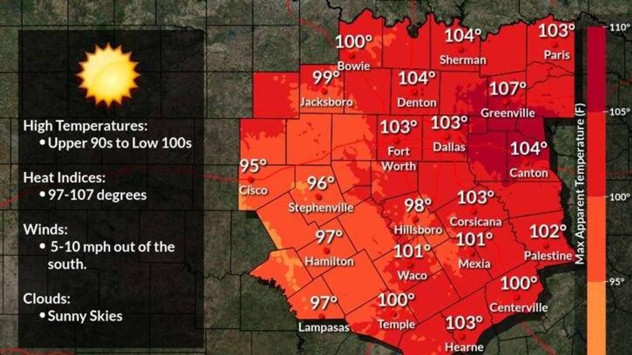
An area of high pressure in the upper levels of the atmosphere will continue to dominate our weather all week and into the weekend.
One thing in our favor, the heat advisories have been allowed to expire, but it'll still feel like it's close to 103゚ during peak heating. Daytime highs over the next 7 days will be in the mid to upper 90s.
I will be keeping an eye on an area of disturbed weather moving towards the Texas coast by the end of the week and into the weekend. This could produce a sea breeze front that may bring some showers and storms in from the southeast Friday into the weekend. Still days away, but will be monitored.
Please stay cool when hydrated, make sure your pets have a cool place to stay if you have to leave home for an extended period of time, and don't forget to put out plenty of water for them!
*Yest Rain: 0.00"; *Yest High: 97; Low: 79
*Today's Averages: High: 95; Low: 75
*Record high: 107 (1952, 2010); Record low: 64 (1949, 56, 61)
*August rain: 4.82"; August surplus: +3.42"
*2021 Rain: 26.84"; 2021 surplus +3.07"
*Sunrise: 6:57am; Sunset: 8:04pm
Today: Mostly sunny and hot. Poor air quality. High: Upper 90s. Heat index: Near 104. Wind: South 5-10 mph.
Tonight: Clear and muggy. Low: Mid to upper 70s. Wind: South 5-10 mph.
Tomorrow: Mostly sunny and humid. Poor air quality. High: Upper 90s. Heat index: Near 104. Wind: South 5-10 mph.
Wednesday and Thursday: Mostly sunny and hot. Poor air quality. High: Upper 90s. Heat near 104 degrees.
Friday - Sunday: Partly cloudy, hot and humid. A bit cooler, with a slight chance for a late afternoon storm. High: Low to mid 90s.