Finally, it rained across much of North Texas over the past 36 hours. DFW Airport has measured almost 2 inches—heavier totals west, lighter totals east. And more welcome rain is on the way, even for those of you who haven't seen a drop yet.
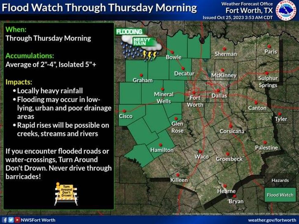
A Flood Watch has been issued. This watch is in effect until tomorrow morning just west of the Dallas-Fort Worth area. This is where the heaviest rain will fall over the next 24 hours. Two to four inches are possible. As of now, I'm thinking one to two inches will fall across the immediate Dallas/Fort Worth area, with lighter totals to our east. The severity will be low. A damaging wind threat will exist just west of I-35W later today.
 National Weather Service - Fort Worth
Wednesday begins with temperatures in the low 70s. The radar is quiet right now, but scattered showers will develop and stream in from the south later this morning. A large area of rain, a line of showers and storms, is a good 200 miles to our west right now. This area of heavy rain will slowly drift towards us by late this afternoon, earlier west of DFW. It's going to be a rainy night across North Texas. The rain will slowly come to an end by noon tomorrow. Afternoon highs will touch 80°.
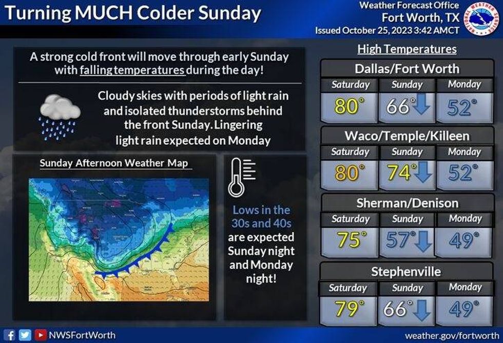
Friday will be cloudy in the morning with peeks of sunshine by the afternoon. High temperatures will reach the low 80s. By Friday evening, more rain will develop ahead of a slow-moving Canadian cold front creeping across the Red River. Most data keeps it north of I-20 on Saturday, but some data has it pressing south of DFW so Saturday's temperature forecast will be very tricky. Right now I'm going 50s along the Red River, near 70 in DFW, and mid-70s to our south. Please keep in mind, that high temperatures are subject to change, depending on the positioning of the cold front on Saturday.
 National Weather Service - Fort Worth
This front will get the push it needs to rapidly press south of the area early Sunday morning. We'll start off Sunday around 60° before Sunrise. Winds will shift to the north and gust to 30 mph, as very chilly air rushes into North Texas. By the noon hour on Sunday, temperatures will already be in the 40s with chilly rain falling.
Monday will be mostly cloudy and cold as the rain presses to our south. Morning lows will be in the low 40s with afternoon highs struggling to hit 50°. Sunshine will return on Tuesday with highs in the low to mid-50s. A slow warm-up will continue through the rest of the week.
 National Weather Service - Fort Worth
*Yest Rain: 1.08"; Yest High: 74; Low: 729
*Today's Averages: High: 75; Low: 54
*Record high: 89 (1927. 1950, 1992): Record low: 35 (1955, 1980)
*October Rain: 2.77"; Deficit: 0.54"
*2023 Rain: 18.43"; Deficit: 12.15"
*Sunrise: 7:40am; Sunset: 6:44pm
Today: **Flood Watch west of DFW through Thursday morning** Cloudy, breezy and muggy. Morning showers, heavier rain slowly moves in later this afternoon. Isolated severe (wind) west of DFW. High: Near 80. Wind: SSE 15-25 mph.
Tonight: Cloudy, breezy and muggy. Widespread heavy rain (1"2"). Heavier west of I-35W. Severity is low. Low: Near 70. Wind: South 10-20, G30 mph.
Thursday: Morning rain, then peaks of sun by afternoon. High: Near 80. Wind: South 15-25, G30 mph.
Friday: Mostly cloudy and mild. Scattered showers and isolated storms by evening. High: Near 80.
Saturday: Scattered showers/isolated storms. Turning colder north of DFW. Highs: 55-70.
Sunday: Cloudy, with a decent chance for rain. Cold front arrives early. Turning windy and sharply colder. High: 60 early, falling into the 40s by the noon hour. Wind chills in the 30s by late afternoon.
Monday: Cloudy, with scattered showers pressing to our south. Windy and COLD! High: Upper 40s.
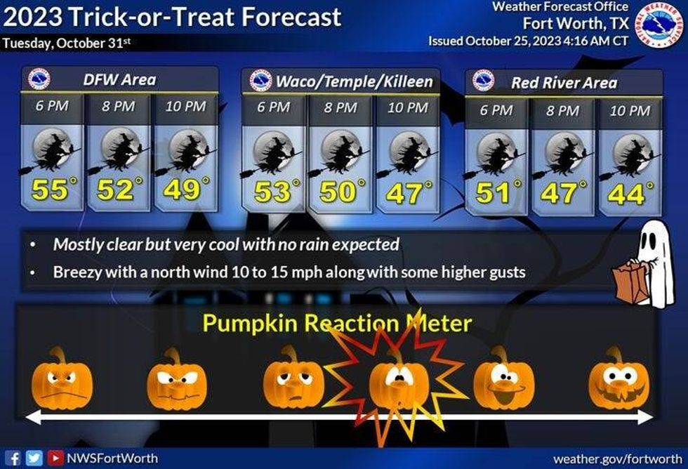
Halloween: Sunny and chilly. High: Low to mid 50s.
LISTEN on the Audacy App
Tell your Smart Speaker to "PLAY 1080 KRLD"
Sign Up to receive our KRLD Insider Newsletter for more news
Follow us on Facebook | Twitter | Instagram | YouTube