A pretty decent weekend is shaping up across North Texas! We do have a small chance for a few isolated showers and storms this evening and again Sunday evening, but most of us will stay dry. In other words, don’t cancel the backyard BBQ, festival plans, or your mission to eat your body weight in funnel cake this weekend. 🌭🎡☀️
Good morning and Happy Fri-yay… or as some of you call it, “Pay-yay Friday!” 💸
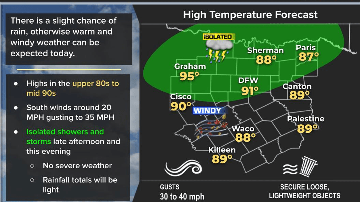
We’re waking up to temperatures in the mid 60s to near 70 degrees. The wind is still behaving itself for now, but give it time… it’s North Texas in May, after all. By this afternoon and through the weekend, breezy conditions return with highs pushing near 90 degrees again Monday. Don’t forget the sunscreen unless you’re trying to match the color of a boiled lobster.
Looking ahead, late Monday night into Tuesday, a cold front will slide into North Texas. The good news? If the front arrives Tuesday morning, as current data suggests, the severe weather threat around DFW should stay fairly low. The bigger concern may end up south and east of the Metroplex where storms could become stronger as the front stalls nearby Tuesday through Thursday.
Now here’s where the forecast gets a little “soap opera-ish.” If that front lifts back north sooner, stronger storms could move back toward Dallas-Fort Worth by Wednesday night into Thursday. If it stays farther south, our severe threat stays lower. Either way, the pattern across Texas is about to turn much more active beginning Tuesday and possibly lasting into next weekend.
So enjoy the quieter weather while you can… because in Texas, weather mood swings are basically part of the state constitution. 🤠⛈️
Have a great weekend everyone, and enjoy the weather when you can… it’s the only weather you’ve got!
7-Day Headlines:
- * DFW Airport reached 91 on Thursday
- * A few evening showers and storms Friday and Sunday
- * Warm and windy through Monday
- * On and off storm chances next Tuesday – Friday
- * Monitoring severe and flooding potential next week.
- * Cooler Tuesday - Friday
- *Yest Rain: 0.00”; Yest High: 91; Low: 68*
- Today’s Averages: High: 83; Low: 64
- *Record high: 97 (2022); Record low 44 (1907)
- *May rain: 1.15”; Deficit: <0.99”>
- *2026 Rain: 11.37”; Snow: 2.4” Deficit: <2.58”>
- *Sunrise: 6:28am; Sunset: 8:21pm
Forecast:
- Friday: Morning sprinkles west of DFW. Partly cloudy, warm and windy. Scattered evening showers and storms. High: Low 90s. Wind: South 10-20, G30 mph.
- Friday night: Slight early evening shower and storm chance. Low: Near 70. Wind: South 10-20, G30 mph.
- Saturday: Morning clouds, afternoon sun. Windy and warm. High: Near 90. Wind: South 10-20, G30 mph.
- Sunday: Morning clouds, afternoon sun. Windy and warm. Slight evening storm chance. High: near 90.
- Monday: Morning clouds, afternoon sun. Windy and warm. Isolated late day showers and storms. High: near 90.
- Tuesday: Morning cold front. Scattered showers and storms. Cooler. High: Low 80s.
- Wednesday and Thursday: Partly to mostly cloudy and pleasant. Scattered showers and storms. Highs: Near 80.
LISTEN on the Audacy App
Tell your Smart Speaker to "PLAY 1080 KRLD"
Sign Up to receive our KRLD Insider Newsletter for more news
Follow us on Facebook | Twitter | Instagram | YouTube