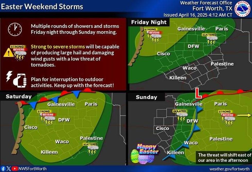
Showers and thunderstorms return to North Texas over the weekend, and some may become severe on Saturday.
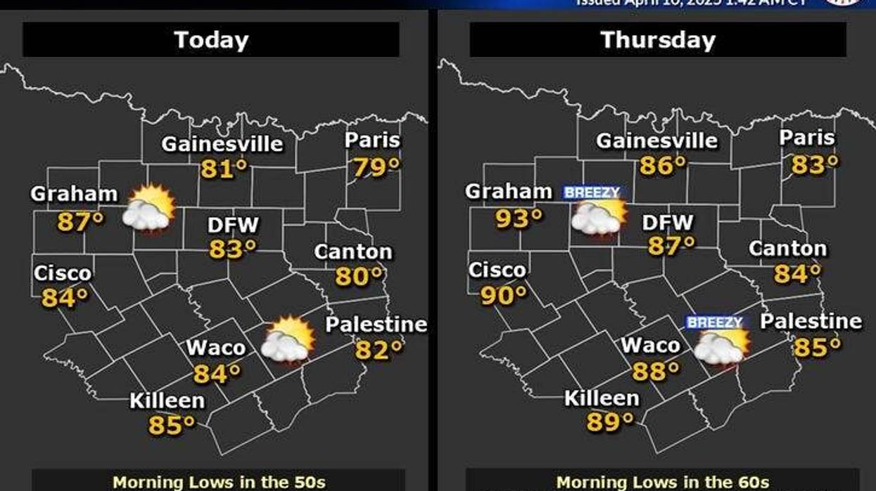
It was a comfortably cool start on Wednesday morning, with temperatures falling into the 40s away from town and 50s elsewhere under a clear sky. We can expect sunny, breezy conditions with low 80s, which is perfect weather for this time of year.
South winds will continue to blow on Wednesday night, bringing in low clouds from the Gulf of Mexico. These clouds will burn off by late Wednesday morning, allowing temperatures to warm up into the upper 80s. South winds will gust up to 35 mph.
We can expect morning clouds and peeks of afternoon sun on Friday, with highs in the mid-80s and winds gusting up to 30 mph. By Friday evening, an area of showers and storms, some severe, will develop to the west of us. It is possible that these storms may have a hard time reaching North Texas by Saturday morning.
Saturday afternoon will bring more showers and storms, some of which may become severe and impact our area through the evening hours. Afternoon highs will remain in the 70s all day. Another line of showers and storms may form to the west of us late Saturday evening and pass through our area before sunrise on Easter Sunday. Some of these storms may be severe.
According to the latest data, the rain should move out just in time for Easter egg hunts mid-morning on Sunday, with temperatures in the 60s and clearing skies by afternoon. Daytime temperatures may not exceed 70 degrees, making for a cool and blustery day.
Monday is expected to be nice with plenty of sunshine and afternoon highs reaching the mid-70s. Tuesday will be partly cloudy and a bit warmer, with highs near 80 degrees, as showers and thunderstorms return to the forecast.
 North Texas weekend forecastNational Weather Service
7-Day Headlines
DFW hit 75 degrees on Tuesday.
Another spectacular day. Wind picks up.
A windy and warm end to the week.
Showers and storms, some severe, return late Friday – early Easter Sunday.
One to three inches is possible.
Clearing Easter morning, turning cooler.
*Rain: 0.00"; Yest High: 75 Low: 55
*Wednesday's Averages: High: 76; Low: 55
*Record high: 95 (2006): Record low: 36 (1905)
_________________________________________________________
*April Rain: 1.31"; Deficit:
*2025 Rain: 10.02"; Deficit:
*Sunrise: 6:56am; Sunset: 8:00pm
_________________________________________________________
Wednesday: Sunny, windy, and warmer. High: Low 80s. Wind: South 15-25 mph.
Wednesday night: Increasing clouds, breezy and mild. Low: Low 60s. South 15-25 mph.
Thursday: Morning clouds, afternoon sun. High: Upper 80s. Wind: South 20-30, G35 mph.
Friday: Morning clouds, afternoon sun. Windy and warm. Scattered late evening showers and storms (west). Some severe. Moving into DFW after midnight. High: Mid 80s.
Saturday: Cloudy and mild. Scattered showers and storms, some severe, through the evening. High: Mid 70s.
Easter Sunday: Early morning showers and storms. Then decreasing clouds, breezy and comfortable. High: Near 70.
Monday: Mostly sunny and nice. High: Mid 70s.
Tuesday: Partly cloudy and warmer. Showers and storms return to the forecast. High: Near 80.
LISTEN on the Audacy App
Tell your Smart Speaker to "PLAY 1080 KRLD"
Sign Up to receive our KRLD Insider Newsletter for more news
Follow us on Facebook | Twitter | Instagram | YouTube
LISTEN on the Audacy App
Tell your Smart Speaker to "PLAY 1080 KRLD"
Sign Up to receive our KRLD Insider Newsletter for more news
Follow us on Facebook | Twitter | Instagram | YouTube