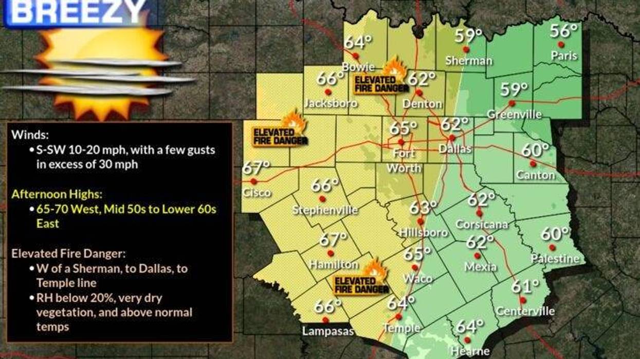
Two things you will notice this morning, a south wind has returned and we're not as cold as the past couple of mornings. We'll also not be as cold today, with daytime highs reaching the mid sixties. It will also be a very windy today with a south wind gusting to 30 mph.
This creates a very high grassfire danger. This scenario usually occurs in January and February due to the lack of rainfall, a strong gusty wind, and low relative humidity.
Wind relaxes a bit tonight as we drop into the mid to upper thirties.
Our next cold front arrives tomorrow morning, shifting our wind back to the north and dropping temperatures into the mid fifties, which is average for this time of the year.
A stronger, Arctic cold front will arrive early Thursday morning, taking temperatures down into the thirties by afternoon. Factor in the wind gusting to 30 mph, it'll feel like its in the twenties most of the day. Unfortunately, no rain with either cold front.
Friday morning will be the coldest morning over the next 7 days, as temperatures fall into the low to mid twenties, but the wind will relax.
It'll stay chilly on Friday with high temperatures struggling to get above 50゚.
A quick warm up with a southerly wind on Saturday. Plenty of sunshine will be enjoyed with highs back in the sixties.
Our next cold front arrives early Sunday, knocking temperatures down into the mid fifties. There could be a few scattered showers well to the East of DFW as well.
Monday looks to be a bit cooler with highs struggling to get about 50゚.
*Yest Rain: 0.00"; *Yest High: 55; Low: 24
*Today's Averages: High: 56; Low: 36
*Record high: 81 (1921); Record low: 4 (1947)
*January rain: 0.05"; January deficit: 0.23"
*2022 Rain: 0.05"; 2022 deficit: 0.23"
*Sunrise: 7:31am; Sunset: 5:35pm
Today: Sunny, windy and warmer today. High grass fire danger. High: Low to mid 60s. Wind: SE 15-25, G30 mph.
Tonight: Clear and chilly. Low: Mid to upper 30s. Wind: South 5-15 mph.
Tomorrow: Sunny, breezy and cooler. High: Mid 50s. Wind: North 10-20 mph.
Thursday: Sunny, windy and much colder. High: Hovering in the 30s! Wind chills in the teens. Wind: North 20-30 mph.
Friday: Morning HARD freeze, otherwise, sunny and cold. High: Mid to upper 40s.
Saturday: Sunny and warmer. High: Low to mid 60s.
Sunday: Partly cloudy, turning windy and cooler. High: Mid 50s.
Monday: Sunny, windy and cool. High: Near 50.
LISTEN on the Audacy App
Sign Up and Follow NewsRadio 1080 KRLD