Below-average temperatures will continue into Saturday before a big warm-up Sunday through the middle of next week, as rain is also expected throughout the weekend.
We're waking up to areas of widespread moderate to heavy rain along and south of Interstate 30. More rain will continue to train over these same areas through early this afternoon. Some areas may pick up close to 2 inches.
Unfortunately, the rain shield, at least most of it, will stay south of Interstate 30. Scattered showers and embedded thunderstorms are possible in these areas, but most totals will be under half of an inch.
Temperatures today will remain below 80°
Another area of rain will develop in the Panhandle tomorrow morning through the afternoon and move southeast through the evening into Saturday morning. Right now, it looks like the heaviest rain totals will be west and south of DFW once again. Afternoon highs tomorrow will struggle to hit 80°.
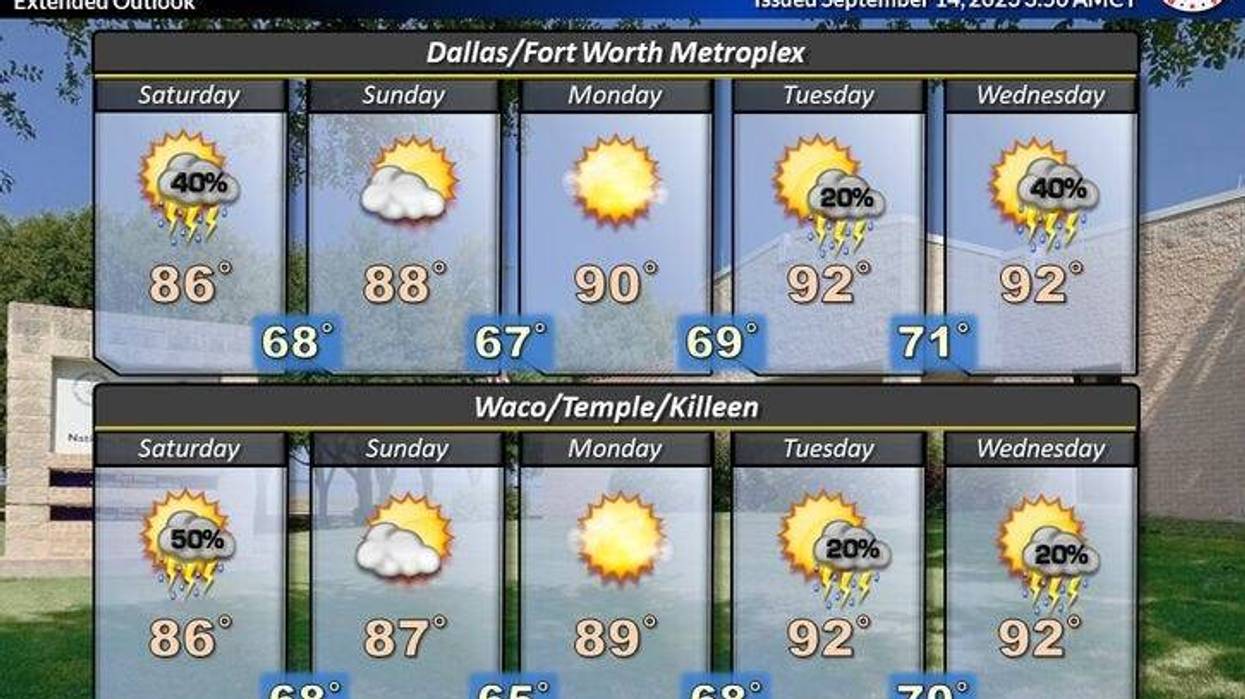
After some morning showers west and south of DFW in the early parts of Saturday, we'll start to dry out and warm up the rest of the weekend and then to next week.
We'll reach the mid-80s on Saturday, upper 80s on Sunday, and low 90s Monday through Wednesday next week.
Some of the extended data has rain moving back into the area by late Wednesday of next week, but that's still 7 days away and is subject to change. Still no triple digits in our forecast and as I said before on social media, the triples are gone for 2023.
Today: Morning rain and isolated storms (heavies south of I-30), then isolated afternoon showers. High: Upper 70s. Wind: East 5-10 mph.
Tonight: Isolated showers. Low: Near 70. Wind: East 5 mph.
Tomorrow: Late-day showers and isolated storms. Heaviest west and south of DFW. High: Low 80s. Wind: ESE 5-10 mph.
Saturday: Morning showers, then partly cloudy and pleasant. High: Mid-80s.
Sunday: Partly cloudy and a bit warmer. High: Upper 80s.
Monday and Tuesday: Mostly sunny and warm. High: Low 90s.
Wednesday: Partly cloudy, continued warm. Slight chance of rain being late.