Another cold blast arriving in North Texas tomorrow, by early afternoon. This will make you uncomfortable through Saturday. Unfortunately, no measurable rain is in the forecast along the front.
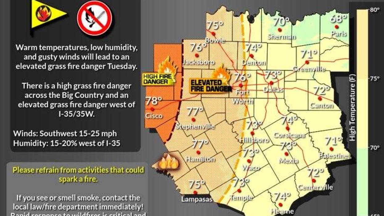
Before we go back to Winter, a little taste of Spring will excite you today, as temperatures warm out of the forties this morning into the low to mid seventies this afternoon. I also want to mention... there is a high grassfire danger off to the west of Fort Worth today.
Temperatures tonight will be mild for this time of the year. Morning lows will only drop into the low to mid fifties.
Wind will increase tomorrow, as a strong cold front plows into the area... right at or shortly after lunchtime. Temperatures will go from near 60 at noon, to the thirties by evening. Factor in the gusty northerly winds and wind chills will be in the the twenties after dinner time. Also, I cannot rule out some patchy drizzle the 2nd half of tomorrow. Some areas to our north and NW MAY experience some light freezing drizzle, but it won't hamper travel.
Hard freezes will plague north Texas Thursday, Friday, and Saturday mornings as temperatures tumble into the twenties. Afternoon highs on Thursday will only be in the mid thirties, low to mid forties on Friday, and near 50 on Saturday.
Our warming trend will continue Sunday and Monday as we push 60゚ by early next week.
*Yest Rain: 0.00"; *Yest High: 65; Low: 31
*Today's Averages: High: 57; Low: 36
*Record high: 80 (1914, 1923); Record low: -1 (1930)
*January rain: 0.08"; January deficit: 1.36"
*2022 Rain: 0.08"; 2022 deficit: 1.36"
*Sunrise: 7:30am; Sunset: 5:47pm
Today: High clouds, windy and mild. High: Low to mid 70s. Wind: South 15-25, G30 mph.
Tonight: Partly cloudy, not as cool. Low: Low to mid 50s. Wind: SSW 15-25 mph.
Tomorrow: Increasing clouds, turning windy and MUCH colder by early afternoon. Light drizzle/Fz. drizzle by late evening. High: Near 60, falling into the 30s by evening. Wind: North 15-25, G30 mph.
Thursday: Morning hard freeze, then partly cloudy, windy and cold. High: mid to upper 30s.
Friday: Morning hard freeze, then mostly sunny and cold. High: Low to mid 40s.
Saturday: Morning freeze, then mostly sunny and continued cold. High: Mid to upper 40s.
Sunday: Sunny and a tad warmer. High: Upper 50s.
Monday: Mostly sunny and nice! High: Low to mid 60s.
LISTEN on the Audacy App
Sign Up and Follow NewsRadio 1080 KRLD