After some welcome rain on Saturday, Sunday turned out to be exceptionally pleasant, and today will follow suit. A new workweek has commenced, and I am monitoring the possibility of any rain heading in our direction.
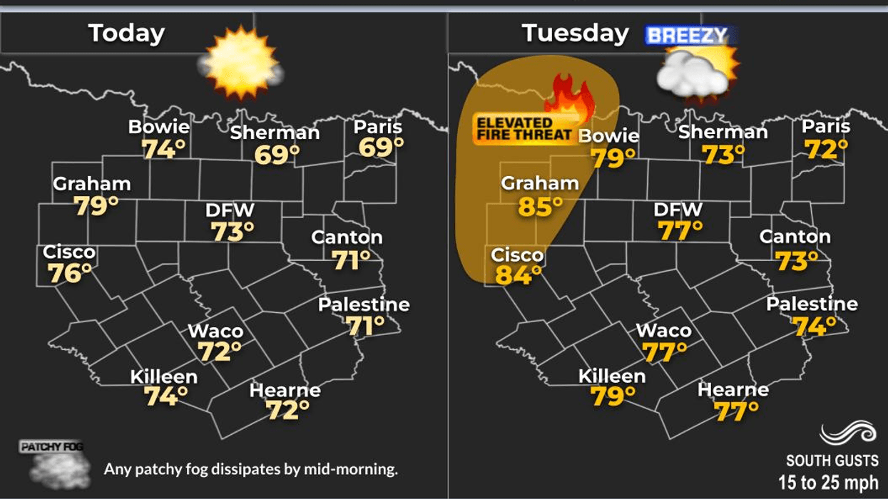
Good morning to my friends and followers and happy President's Day. I hope everyone had a great Valentine's weekend, and now it's back to work and school. We are waking up to temperatures in the 40s at this hour, with some patchy fog developing across the area. There is a dense fog advisory in effect well to the east and northeast of the Dallas-Fort Worth area, but no advisories have been issued for our region. Today will be another beautiful day, and I encourage those who have the day off to take advantage of the sunshine and spend some time outdoors.
The main jet stream has shifted north of the Dallas-Fort Worth area, deflecting any storm systems moving into California into the plains states this week. This is welcome news for ski enthusiasts in the High Sierra, the Wasatch Range, and the Colorado Rockies, who have experienced a disappointing ski season thus far.
A weak upper-level ridge of high pressure will dominate our region for most of the week, leading to above-average temperatures. Afternoon highs today will reach the mid-70s, approaching 80 degrees on Tuesday, Wednesday, and Thursday, before returning to the mid-70s on Friday.
A cold front is expected to move into the area by Friday evening, although some models suggest it may linger north of us until Saturday afternoon. If the front stalls in the area on Friday night and early Saturday, we may see scattered showers along the front. However, the entire weekend will not be a washout. Once the front passes, drier air will filter in, skies will clear, and humidity will drop. It will also be very windy on Saturday, with afternoon highs only reaching the low 60s. Sunday is expected to be sunny, with highs in the mid-60s.
At present, I do not foresee any Arctic air invading our region in the near future. However, I am monitoring temperatures in Alaska, which are starting to warm up again. When this occurs, we typically experience a significant cold snap east of the Rockies. If this happens, it will likely occur towards the end of February. I will continue to monitor the situation and provide updates as necessary.
Have a terrific President's Day, and please enjoy the weather when you can, it's the only weather you've got!
7-Day Headlines:
* DFW Airport reached 70 yesterday.
* Another beautiful day today. A windy Tuesday.
*Above average temperatures all week.
* Slight rain chance Friday and Saturday.
* Cooler this weekend.
* Warming back up next week.
*Yest Rain: 0.00"; Yest High: 70; Low: 53
*Today's Averages: High: 61; Low: 40
*Record high: 85 (2006); Record low -2 (2021)
*February rain: 1.31"; Deficit:
*2026 Rain: 2.24"; Snow: 2.4" Deficit:
*Sunrise: 7:09am; Sunset: 6:15pm
Monday: Partly cloudy and beautiful! High: Mid 70s. Wind: South 5-10 mph.
Monday night: Partly cloudy, not as cool. Low: Low to mid 50s. Wind: South 10-20 mph.
Tuesday: Partly cloudy and mild. High: Near 80. Wind: South 15-25, G35 mph.
Wednesday and Thursday: Partly cloudy and pleasant. Highs: Near 80.
Friday: Increasing clouds. A cold front may sag into the area. A few showers are possible. Highs: 65-78.
Saturday: Morning showers, then decreasing clouds, windy and cooler. High: Low 60s.
Sunday: Sunny, breezy and cool. High: upper 50s.
LISTEN on the Audacy App
Tell your Smart Speaker to "PLAY 1080 KRLD"
Sign Up to receive our KRLD Insider Newsletter for more news
Follow us on Facebook | Twitter | Instagram | YouTube