


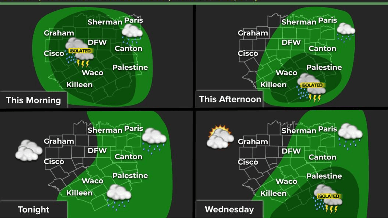
Waves of heavy rain will persist across North Texas, moving from southwest to northeast through the morning and into the afternoon hours. None of these storms will become severe, but most areas will receive at least one to one and a half inches of rain before the system exits to the east later this afternoon.
Good morning, everyone. I'm Meteorologist Dan Brounoff in the KRLD Weather Center. We're waking up to temperatures in the mid to upper 50s, and again, those waves of rain will continue to impact travel across North Texas throughout the day. Temperatures will not warm up significantly, with afternoon highs reaching only the low 60s.
Tonight, we'll see areas of light showers, with temperatures holding steady near 60 degrees. Tomorrow morning will bring clouds with peeks of afternoon sun. A few scattered showers are not out of the question as temperatures warm into the low to possibly mid-70s, depending on the amount of sunshine.
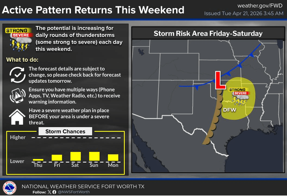
Thursday and Friday look relatively dry, with morning clouds and afternoon sun. Temperatures will warm into the low 80s on Thursday but reach the upper 80s on Friday. Additionally, the dryline will become active to our west, and a cold front will approach the Red River Valley, bringing a chance for strong and isolated severe storms to develop late in the afternoon and evening. Hail and wind will be the primary threats.
The same scenario will unfold on Saturday: morning clouds, afternoon sun, and a threat for isolated severe storms toward the late afternoon and evening, with hail and wind as the threats, and temperatures in the upper 80s. We can also expect a chance for isolated severe storms on Sunday, with a 30% coverage.
Currently, Monday looks relatively dry, but still warm, with highs near 90 degrees, and new data suggests that the cold front may not pass through North Texas, or if it does, it will clear out and cool off by Monday.
Enjoy the rain and weather when you can, it's the only weather you've got.
7-Day Headlines:
- DFW Airport reached 72 on Thursday.
- Wave of rain most of the day
- Nothing severe expected
- Tuesday stays in the 60s
- 1.00” of rain through Tuesday afternoon. Isolated heavier totals
- Isolated showers Wednesday
- Isolated severe weather Friday - Sunday (evening hours)
- Download our AUDACY app. Listen to KRLD at home!
Almanac:
- Yest Rain: 0.00”; Yest High: 72; Low: 51
- Today’s Averages: High: 77; Low: 57
- Record high: 95 (1955); Record low 37 (2021)
- April rain: 3.17”; Surplus: 1.16”
- 2026 Rain: 8.33”; Snow: 2.4” Deficit: <2.27”>
- Sunrise: 6:50am; Sunset: 8:04pm
Forecast:
Tuesday: Cloudy and cool. Waves of moderate rain with thunder.Off and on rain. Nothing severe. High: Low 60s. Wind: South 5-10 mph.
Tuesday night: Cloudy and cool. Isolated showers. Low: Near 60. WInd: South 5-10 mph.
Wednesday: Mostly to partly cloudy and warmer. Isolated showers. High: Mid 70s. South 10-20 mph.
Thursday: Morning clouds, some afternoon sun. Windy. High: Low 80s.
Friday: Morning clouds, afternoon sun. Very warm. Isolated evening strong/severe storms. High: Upper 80s.
Weekend: Morning clouds, afternoon sun. Very warm. Isolated evening strong/severe storms. High: Upper 80s.
Monday: Mostly sunny and warm. Cold front? High: Upper 80s.
LISTEN on the Audacy App
Tell your Smart Speaker to "PLAY 1080 KRLD"
Sign Up to receive our KRLD Insider Newsletter for more news
Follow us on Facebook | Twitter | Instagram | YouTube


