Waves of rain through the morning hours, a strong cold front late this afternoon, much cooler Tuesday and Wednesday, and then a warming trend Thursday into Easter weekend.
We hope you've enjoyed the overnight rain. We will continue to see more rain through mid to late morning before everything shifts off to our east. Nothing severe is expected. Temperatures are near 60° this morning and we'll warm into the low 70s by this afternoon as sunshine reappears.
A strong cold front will arrive in the early evening bringing a slight chance of rain showers with it. It'll turn windy and much colder through the evening and overnight.
 National Weather Service - Fort Worth
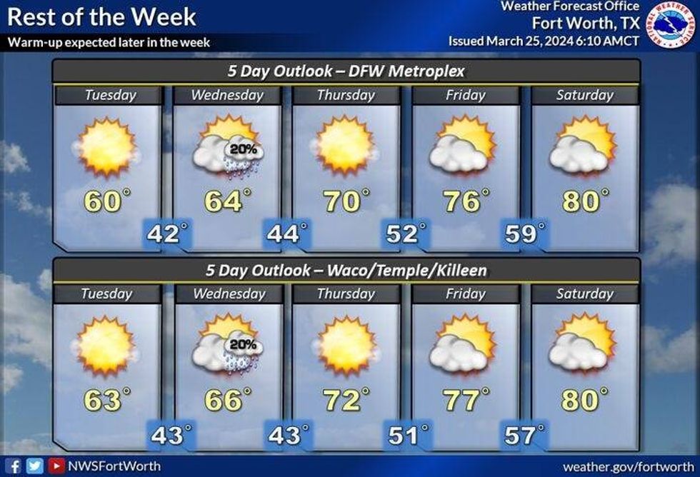
Temperatures will fall into the upper 30s to low 40s by Tuesday morning. Plenty of sunshine will dominate, but it will be unseasonably cool for this time of the year. High temperatures will only be near 60°.
Protect your plants before you go to bed Tuesday evening, as temperatures will fall back into the upper 30s to low 40s on Wednesday morning. There's a slight chance of a few showers late Wednesday, otherwise, we will enjoy another cool day with readings in the mid-60s.
Temperatures will slowly warm on Thursday under a partly cloudy sky. Readings will top out in the low 70s. Our warming trend will continue Friday into Easter weekend. Upper 70s on Friday, low 80s on Saturday, mid 80s on Easter Sunday.
*Yest Rain: 0.19"; Yest High: 68 Low: 57
*Today's Averages: High: 71; Low: 50
*Record high: 97 (1899); Record low: 26 (1955)
*March Rain: 4.82"; Surplus: 2.24"
*2024 Rain: 9.96"; Surplus: 2.09"
*Sunrise: 7:24am; Sunset: 7:44pm
LISTEN on the Audacy App
Tell your Smart Speaker to "PLAY 1080 KRLD"
Sign Up to receive our KRLD Insider Newsletter for more news
Follow us on Facebook | Twitter | Instagram | YouTube