Daniel Brounoff
5:27 AM (17 minutes ago)
to me
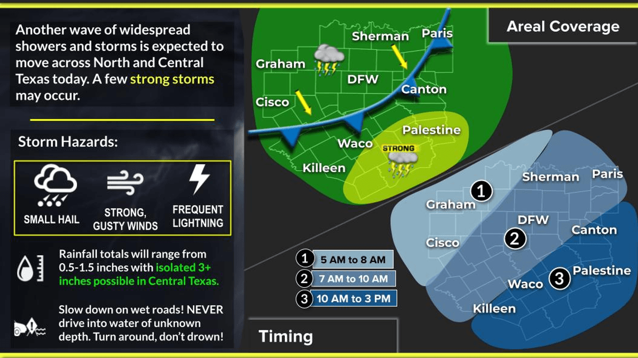
A cold front has shifted south of DFW this morning, with one more area of non-severe showers and storms expected to impact North Texas, primarily south of US 380, through the noon hour.
Good morning, ladies and gentlemen. While most areas did not receive rain last night, this morning will be different. A lingering disturbance trailing the cold front will move across North Texas between 7:30 and 11:00 a.m., bringing rain but no severe weather. Be prepared for potential disruptions to your lunch plans and have an umbrella handy.
Most areas will experience a rain-free commute this morning, except for counties west of Interstate 35W. Temperatures will remain in the 70s in rainy areas, rising to the low 80s as skies clear throughout the afternoon.
The effects of the cold front will be more pronounced tomorrow morning, with temperatures dipping into the upper 50s to mid-60s and afternoon highs reaching the low to mid-80s under sunny skies. A surface high-pressure system will move in from the Northeast on Friday, maintaining cool mornings and seasonally warm afternoons through the weekend. Afternoon highs will reach the mid-80s on Thursday and upper 80s on Friday, with morning lows mainly in the 60s and some areas experiencing mid-to-upper 50s. No precipitation is forecasted.
Comfortable mornings and warm afternoons will persist throughout most of next week, as a dry weather pattern continues to dominate the region. Enjoy the rain this morning, have a great day and remember to enjoy the weather when you can, it's the only weather you've got!
7-Day Headlines:
* DFW Airport reached 97 on Sunday.
* Showers and storms through noon.
* Cooler today through the weekend. Cool mornings.
* No rain for a while after today.
* Warm and dry for the opening weekend of the State Fair.
* Dry and warm next week.
*Yest Rain: 0.00"; Yest High: 97; Low: 78
*Today's Averages: High: 86; Low: 66
*Record high: 102 (2023); Record low: 49 (1989)
*September Rain: 1.05"; Deficit:
*2025 Rain: 28.10"; Surplus: 1.38
*Sunrise: 7:18am; Sunset: 7:20pm
Wednesday: Late morning non severe storms, pockets of heavy rain, becoming partly cloudy and MUCH cooler. High: Low 80s. Wind: North 10-20 mph.
Wednesday night: Clear and cool. Low: 58-64. Wind: North 5-10 mph.
Thursday and Friday: Mostly sunny and seasonable. Highs: Mid to upper 80s.
Weekend: Partly cloudy and warm. Highs: Upper 80s.
Monday and Tuesday: Continued partly cloudy and warm. Highs: Upper 80s.
LISTEN on the Audacy App
Tell your Smart Speaker to "PLAY 1080 KRLD"
Sign Up to receive our KRLD Insider Newsletter for more news
Follow us on Facebook | Twitter | Instagram | YouTube