Mostly cloudy skies this morning with temperatures in the upper sixties to low seventies. Today will be relatively rain free with highs back near 90゚. Heat index values will reach the mid to upper 90s. Stay hydrated.
Our next weather change arrives from the south this time. An area of low pressure at the surface, currently in south Texas, will edge northbound over the next 36 hours.
Widespread shower and non severe thunderstorms will start creeping in from the south and will arrive in our southern counties after midnight tonight. Pockets of heavy rain will move across north Texas during the day tomorrow, with the heaviest rain along and east of I-35. Some areas will pick up 1" to 2" of welcome rain, with isolated higher totals east of Dallas. High temperatures will hover in the mid seventies all day long.
A brief break in the rain is forecast on Thursday and most of Friday with high temperatures in the middle eighties.
 National Weather Service - Fort Worth
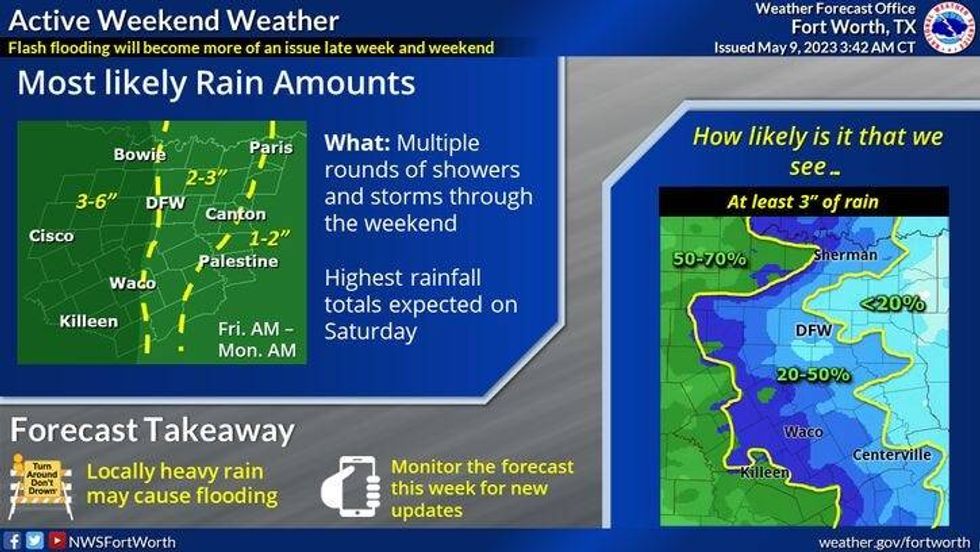
Another strong storm system edges our direction this weekend. Widespread shower and thunderstorm activity will creep in on Saturday and especially on Sunday. Some areas may pick up an additional 2"-3" of welcome rain, with isolated higher amounts possible. Afternoon highs will hover in the seventies all weekend.
A pretty decent cold front will edge through the area Sunday night taking the heaviest rain out of north Texas, but some residual shower activity will continue into the first half of Monday. Temperatures on Monday may struggle to reach seventy degrees.
*Yest Rain: 0.10"; Yest High: 89; Low: 71
*Today's Averages: High: 81; Low: 62
*Record high: 97 (1952): Record low: 46 (1923, 1969)
*May Rain: 0.30"; Deficit: 0.90"
*2023 Rain: 11.42"; Deficit: 1.48"
*Sunrise: 6:36am; Sunset: 8:16pm
Today: Morning clouds, afternoon sun. Very humid and hot! Scattered late day storms, mainly south of DFW. High: Upper 80s. Heat index: Mid 90s. Wind: SE 5-10 mph.
Tonight: Cloudy, with scattered showers and storms approach from the south. Warm and humid. Low: 68-72. Wind: SE 10-20 mph.
Tomorrow: Cloudy and cooler. Numerous showers and storms. Rain may be heavy at times: 1"-2" possible. Heaviest rain east of DFW. Severity VERY low. Cooler. High: Upper Mid to upper 70s. Wind: SE 10-20 mph.
Thursday and Friday: Mostly to partly cloudy, warm and humid. Scattered late afternoon and evening storms on Friday. Highs: Mid 80s.
Weekend: **Flooding potential** Numerous showers and storms. Rain could be heavy at times. Rain totals: 2"3", with isolated higher totals west of I-35W. Highs: Mid to upper 70s.
Monday: Mostly cloudy and cooler. Leftover showers and isolated storms. Cooler. High: Near 70.

LISTEN on the Audacy App
Tell your Smart Speaker to "PLAY 1080 KRLD"
Sign Up to receive our KRLD Insider Newsletter for more news