


We're waking up to temperatures in the 70s, a ton of humidity and scattered showers dotting North Texas. Showers and thunderstorms are starting to intensify and increase in coverage to our west.
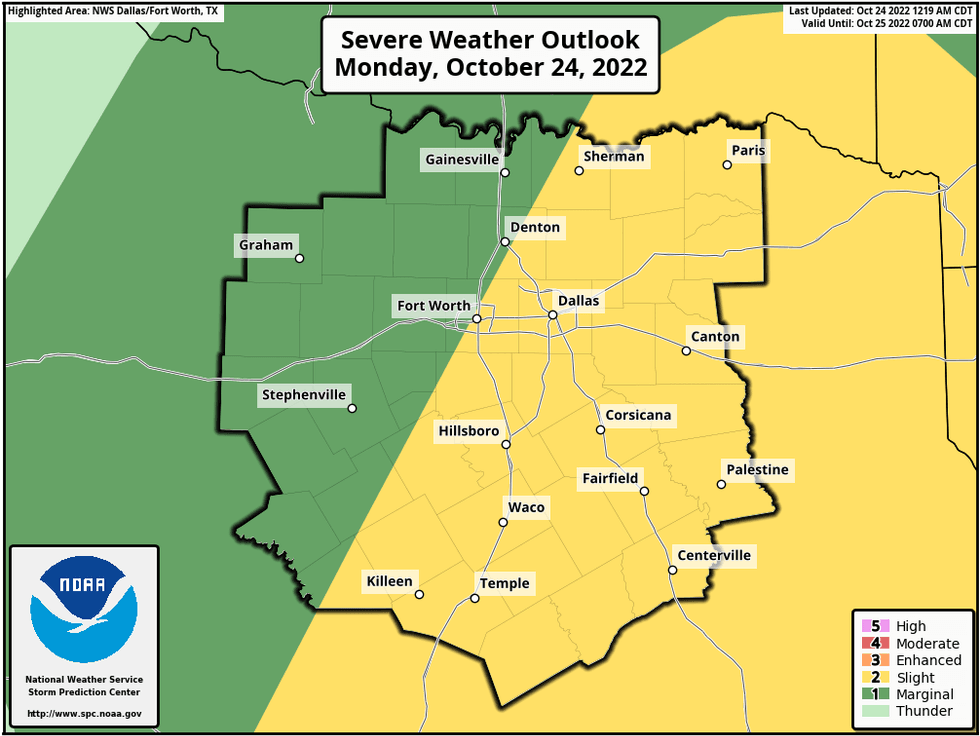
This area of rain will move though North Texas late this morning into the early afternoon hours. I can't rule out a few strong storms and possibly an isolated severe storm as well. Temperatures will be steady in the low 70s all day.
I'm expecting a brief break in the rain this afternoon, but another area of storms will form to the west of us this evening as the cold front approaches. This is when we'll see the best chance for isolated severe storms, mainly east and southeast of DFW. Wind, small hail, and a brief tornado are possible.
Everything should press east of the area after midnight. Rainfall totals will be between 1 to 2 inches, with isolated higher totals possible.
 National Weather Service - Fort Worth
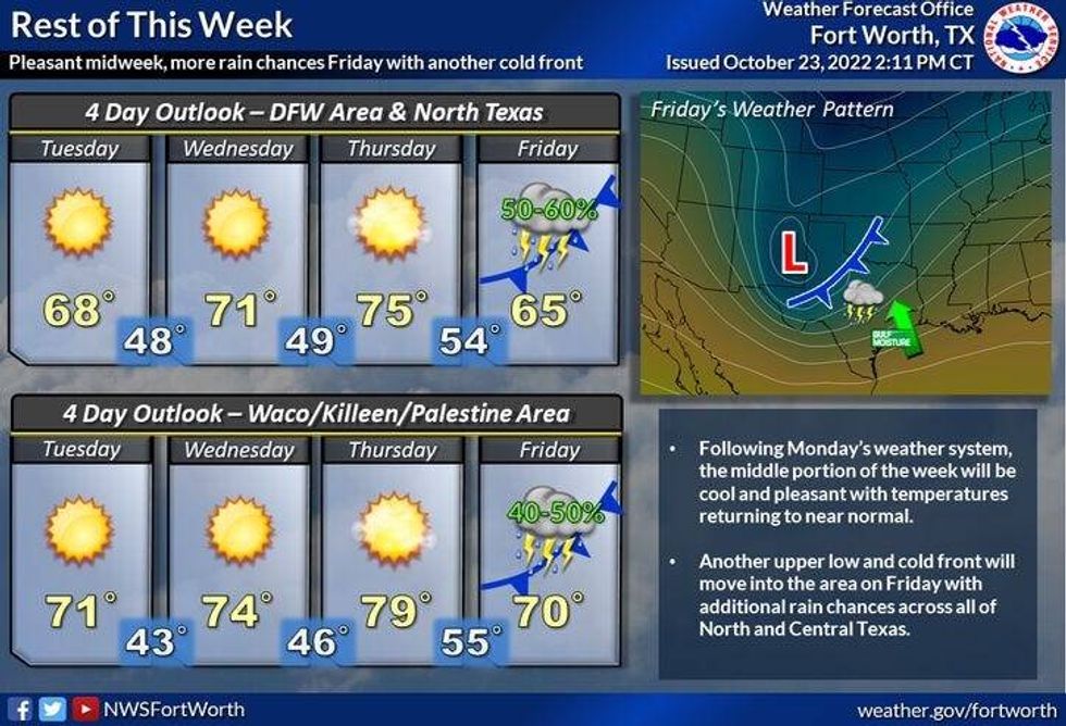
Our weather Tuesday - Thursday will be nice. Afternoon highs will be in the upper 60s tomorrow, low 70s on Wednesday and mid to upper 70s on Thursday.
By Thursday night and Friday, we've got another pretty decent shot of showers and storms across north Texas. It's still way too early to say if we'll see anything severe.
Temperatures will be quite cool on Friday with afternoon highs hovering in the 60s. Slow clearing on Saturday with readings in the mid 60s. Sunshine and beautiful for Sunday with readings in the low 70s.
 National Weather Service - Fort Worth
*Yest Rain: 0.00"; High: 87; Low: 70
*Today's Averages: High: 75; Low: 54
*Record high: 90 (2003); Record low: 34 (1917)
*October rain: 0.07"; October deficit: 3.07"
*2022 Rain: 23.49"; 2022 deficit: 6.92"
*Sunrise: 7:39am; Sunset: 6:45pm
 Audacy
Today: Widespread showers and storms. Isolated severe for wind, small hail and **isolated tornadoes (SE of DFW)**. 0.50" - 1.5" of rain possible. High: Steady near 70 degrees. Wind: South to west 15-25 mph.
Tonight: Showers and storms early, then decreasing clouds, windy and much cooler by daybreak. Low: 48-52. Wind: WNW 10-20 mph.
Tuesday: Morning clouds (east and north), afternoon sun. Windy and cool. High: Mid 60s. Wind: NW 15-25, G30 mph.
Wednesday: Sunny and pleasant. High: Low to mid 70s.
Thursday: Increasing clouds, breezy and seasonable. Showers and storms possible by late evening. High: Mid to upper 70s.
Friday: Scattered showers and storms. Clearing late. High: Mid 60s.
Saturday: Sunny, breezy and cool. High: Upper 60s.
Sunday: Sunny and pleasant. High: Low 70s.

LISTEN on the Audacy App
Sign Up and Follow NewsRadio 1080 KRLD


