


UPDATE: 6:15 p.m.
Storms are about ready to pop out in West Texas between 6-7 p.m. Individual cells will be able to produce large hail and an isolated tornado between 6 and 8 p.m. After that, these cells will shake hands with each other forming a good old fashioned Texas squall line as it approaches I-35W at or shortly after midnight.
As this line approaches North Texas, some weakening may happen between 1 a.m. and 3 a.m. Brief heavy rain, dangerous lightning, small hail, and isolated pockets of damaging wind are possible.
NOTE: If there are any kinks, breaks, or bowing segments in this line, and an individual area decides to increase in intensity, this is where a weak tornado could form, but chances are VERY slim.
This event will mainly be a bunch of noise and wind as it moves through the area while you're sleeping.
Some intensification in this broken line is possible as it presses just east of Dallas before daybreak.
Moderate rain will continue across the area during your morning commute, ending from west to east by mid-morning. Rainfall totals will mainly be less than 0.50", with isolated higher amounts possible.
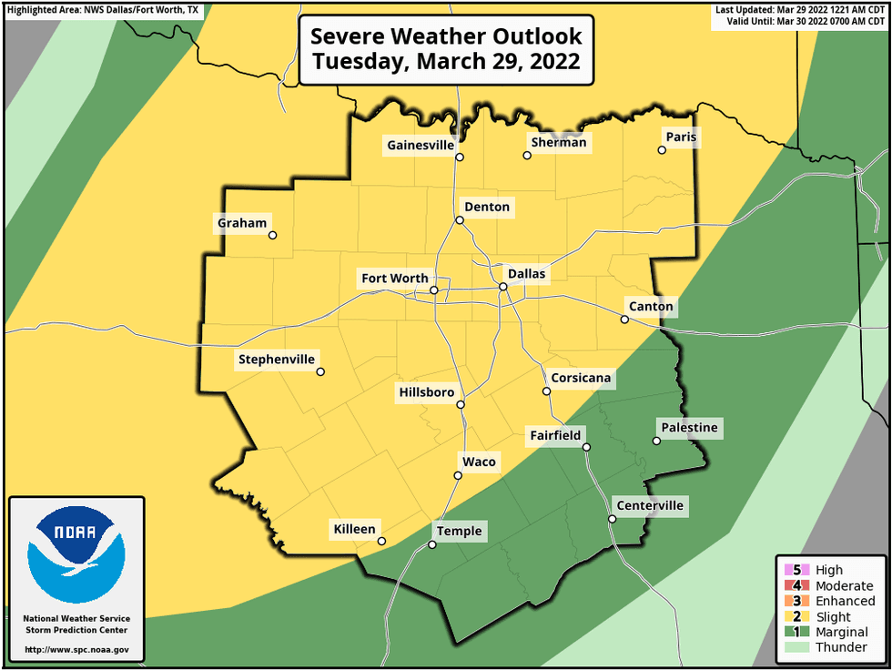
We're waking up to cloudy skies, very windy conditions, and temperatures well above average for this time of the year. We also have a Wind Advisory in effect today, and the threat for severe weather moving in from the west after midnight tonight, through 6 AM tomorrow morning.
Things are quiet this morning with temperatures in the upper sixties. We won't be as warm today as we have been the past couple of days. Daytime highs will approach 80゚. Clouds will stick around through most of the day with some peaks of sunshine later this afternoon.
Stay weather aware after midnight tonight, as a line of showers and storms plows through north Texas. The threats are damaging wind and small hail, however a weak tornado is never out of the question along the leading edge of squall lines.
We'll still have some rain around for your morning commute tomorrow, as we settle to near 60゚. The rain will press the east by mid morning and skies will clear after the noon hour.
It will be very windy tomorrow with gusts to 40 to 45 mph possible...highs will warm into the low seventies.
Thursday through the weekend look nice, with highs in the mid seventies to near 80 by Sunday.
Our next chance for strong to severe storms looks to be next Monday, but we'll cross that bridge when we get there.
*Yest Rain: 0.00"; *Yest High: 86; Low: 60
*Today's Averages: High: 73; Low: 51
*Record high: 88 (1946, 1967); Record low: 28 (1944)
*February rain: 1.18"; March deficit: 1.81"
*2022 Rain: 3.29"; 2022 deficit: 4.99"
*Sunrise: 7:19 am; Sunset: 7:47pm
Today: *Wind Advisory* Mostly cloudy, windy and muggy. Elevated grass fire danger, especially west of Fort Worth. High: Near 80. Wind: South 15-25, G35 mph
Tonight: Isolated severe storms after midnight (1am- 5am from west to east). Threats: Small hail, damaging wind, isolated weak tornadoes. Rain totals: 0.50"- 1.00". VERY windy. Low: Near 60. Wind: South 20-30, G45mph.
 Isolated severe storms after midnight (1am- 5am from west to east).National Weather Service - NOAA
Tomorrow: Early morning storms, then decreasing clouds, VERY windy, lowering humidity and cooler. High: Low 70s. Wind: WSW: 20-30, G40 mph.
Thursday: Sunny and perfect! High: Near 70.
Friday: Partly cloudy and nice. High: Mid 70s.
Saturday: Isolated morning showers, then sunny, breezy and pleasant. High: Low 70s.
Sunday: Sunny and warmer. High: Near 80.
Monday: Mostly cloudy. Strong storm chances return. High: Upper 70s.


