


Here comes the wind again. Widespread wind advisories will be in effect across North Texas from 10 a.m. to 10 p.m. on Tuesday, with wind gusts potentially reaching 45 mph, especially toward the Red River Valley. There is also a critical grass fire danger, particularly west of Interstate 35W, Tuesday and Wednesday, as a strong cold front is expected to blow through early Wednesday morning, albeit rain-free.
Tuesday featured a mild morning across North Texas under clear skies. Temperatures fell into the upper 50s to low 60s with south winds gusting up to 25 mph. Gusts will reach 45 mph Tuesday afternoon. Afternoon highs will be warm, with readings in the mid-80s.
A cold front will enter the picture before daybreak on Wednesday, shifting the winds to the northwest with gusts up to 35 throughout the day. Tomorrow morning will begin in the mid to upper 50s but end the day only in the mid-60s. It'll be a chilly, blustery day, despite the sunshine.
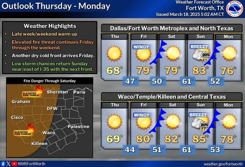
Thursday will feature plenty of sunshine, pleasant temperatures, and light wind. Afternoon highs will kiss the 70-degree mark.
Southwinds will rapidly increase by Friday, and it will be breezy, with strong, gusty winds continuing through the weekend. Daytime highs on Friday will warm into the upper 70s, low 80s on Saturday, and mid-80s on Sunday. South winds will gust up to 35 mph, and the grass fire danger will persist.
Sunday's cold front may bring scattered strong and isolated severe storms across parts of North Texas. All data suggests these will form just south of Interstate 20.
Breezy, cooler weather, along with lower relative humidity, will greet us on Monday, with high temperatures near 70 degrees.
 North Texas forecast.National Weather Service
7-Day Headlines
DFW reached 83 degrees on Monday.
Wind Advisory on Tuesday, gusts to 40 mph.
Grass fire danger through Wednesday.A lot of wind this week.
Cooler on Wednesday and Thursday.
Warming into the weekend.
Possible storms for some late Sunday.
*Monday Rain: 0.00"; Monday High: 83 Low: 91
*Tuesday's Averages: High: 69; Low: 48
*Record high: 97 (1907): Record low: 20 (1923)
_________________________________________________________
*March Rain: 0.97"; Deficit:
*2025 Rain: 8.01"; Surplus: 0.89"
*Sunrise: 7:33am; Sunset: 7:39pm
_________________________________________________________
Tuesday: ** Wind Advisory 10 a.m.-10 p.m. ** Mostly sunny, windy and warm. Grass fire danger west of I-35W. High: Mid-80s. Wind: South 20-30, gusts up to mph.
Tuesday night: Passing high clouds and mild. Low: Low to mid-50s. Wind: South 15-25, gusts up to 35 mph.
Wednesday: Morning cold front. Sunny, windy, and cooler. High: Mid 60s. Wind: NW 15-25, gusts up to 35 mph.
Thursday: Sunny, less wind and seasonable. High: Upper 60s.
Friday: Mostly sunny, windy and warmer. Stalling cold front late. High: Near 80.
Weekend: Partly cloudy, windy and warm. Scattered strong storms south of I-20 late Sunday. Highs: Low to mid-80s.
Monday: Sunny, breezy, and cooler. High: Near 70.
LISTEN on the Audacy App
Tell your Smart Speaker to "PLAY 1080 KRLD"
Sign Up to receive our KRLD Insider Newsletter for more news
Follow us on Facebook | Twitter | Instagram | YouTube


