


In case you haven't noticed yet, it's been very windy since yesterday evening! Peak wind gust at DFW so far has been 54 mph. A Wind Advisory is in effect through 6:00 p.m. today with winds gusting as high as 50 mph through mid afternoon.
We're starting off this morning in the low to mid 30s. Wind chills have fallen into the upper teens to low 20s. Bundle up and layer up! Plenty of sunshine today, windy and cold with afternoon highs in the upper 40s. Wind chills in the 30s.
The wind relaxes a bit tonight with morning lows in the low to mid 30s.. Afternoon highs tomorrow will reach near 60° as southerly winds return and gust to 35 mph.
Thursday is our warmest day for a while. Afternoon highs will approach 70° in areas, especially west of Fort Worth.
 National Weather Service - Fort Worth
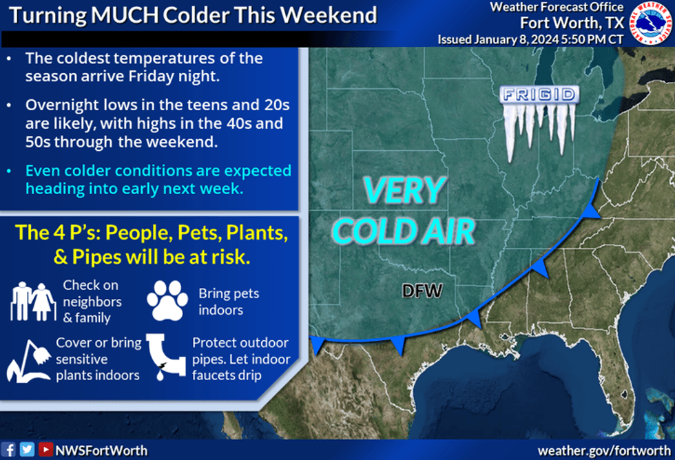
Another strong Canadian front arrives early Friday morning. Temperatures shortly after midnight will be in the mid 50s. You'll wake up to temperatures in the mid to upper 20s with north wind gusting to 45 mph. 6:00 a.m. temperatures will be in the mid to upper 20s. We'll struggle to get above 40° Friday afternoon. There's a very slight chance of some showers and storms early Friday, best chances will be east of DFW.
Saturday will be sunny and cold. Afternoon highs will reach the mid 40s.
 National Weather Service - Fort Worth
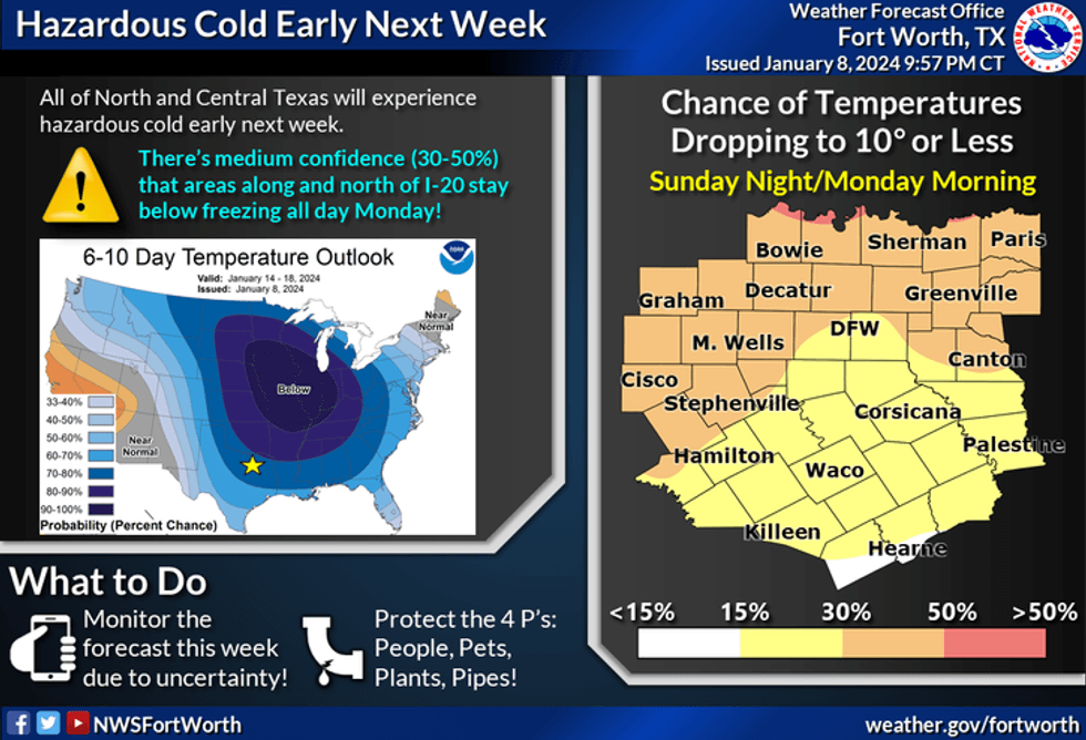
Sunday is a tricky forecast. It all depends on when the Arctic air arrives. Right now I'm going near 60 around Hillsboro, near 40 around Dallas and Fort worth, and mid twenties along the Red River Valley. These will be afternoon highs. I may tweak these up or down depending on where the front lays Sunday afternoon. Either way, the coldest air in quite some time will be impacting our weather to start next week off.
Morning lows on Monday will be in the single digits to low teens with afternoon highs most likely not getting above 20°. This cold air will stick around until Wednesday before we slowly moderate towards the end of the week. Again, I will keep an eye on the wintry precipitation changes late Sunday into MLK Day.
Please prepare yourself for pipe-bursting weather this weekend and into the first part of next week. Make your preparations now.
*Yest Rain: 0.47"; Yest High: 57 Low: 39
*Today's Averages: High: 56; Low: 36
*Record high: 82 (1957); Record low: 12 (1962, 1977)
*January rain: 1.31"; Surplus: 0.60"
*2024 Rain: 1.31"; Surplus: 0.60"
*Sunrise: 7:32am; Sunset: 5:39pm
LISTEN on the Audacy App
Tell your Smart Speaker to "PLAY 1080 KRLD"
Sign Up to receive our KRLD Insider Newsletter for more news
Follow us on Facebook | Twitter | Instagram | YouTube


