


A heck of a lot of wind, cool temperatures, warming temperatures, and more severe storms? Welcome to April in North Texas!
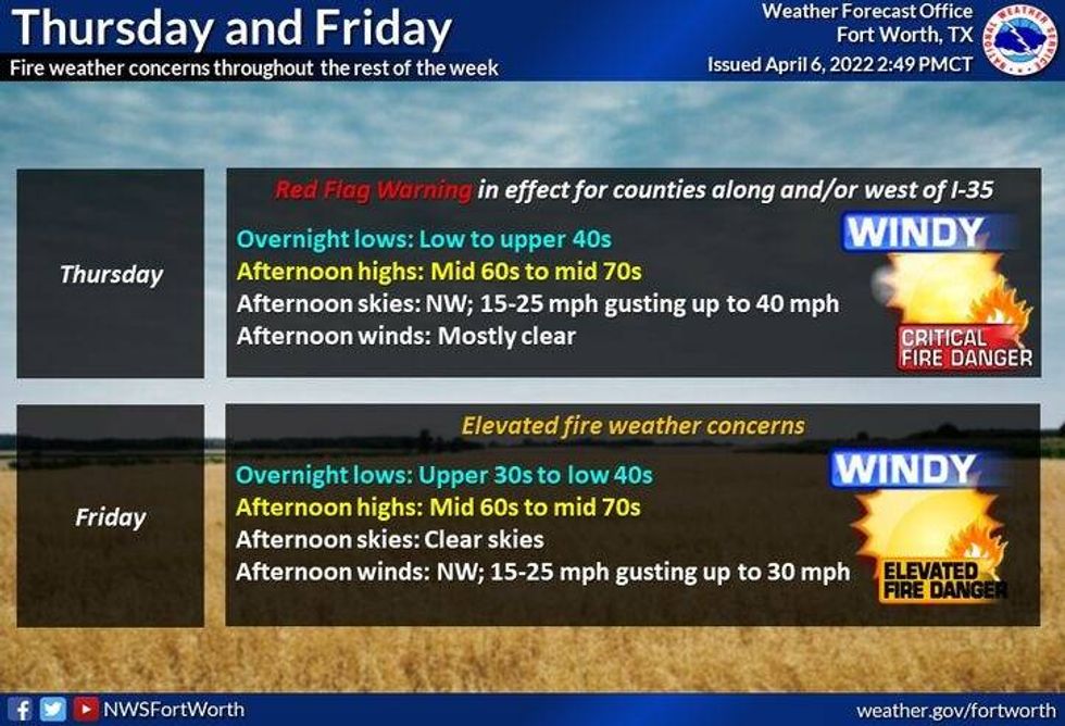
Another windy day is in store for North Texas Thursday afternoon! It's not too bad out this morning -- the wind is light and temperatures have cooled into the 40s to low 50s. I hope you brought your potted plants indoors, especially away from the city. A couple more cool mornings are ahead Friday and Saturday. Afternoon highs on both days will be very comfortable for this time of the year and slightly below average. Readings will kiss the 70-degree mark.
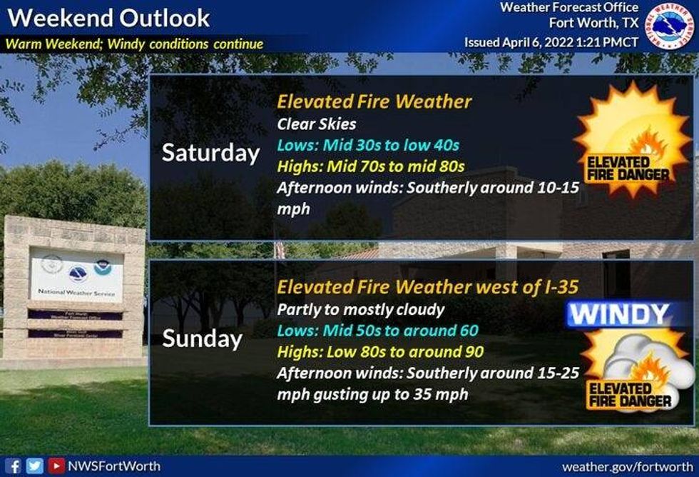
A rapid warm-up will take shape this weekend, as a southerly wind returns. There is grassfire danger Thursday through Sunday.
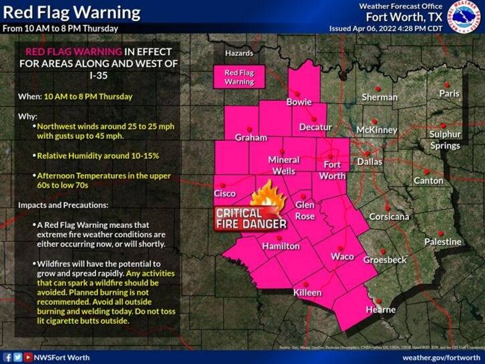
Red Flag Warnings are posted for most of the Panhandle, South Plains and North Texas Thursday. As calculated by the Texas A&M Forest Service, the state's fire danger ranges from Elevated to Extreme. A Red Flag Warning posted by the National Weather Service in Fort Worth runs through 8 p.m.
Of Texas' 254 counties, 150 have ordered burn bans. That includes a number of North Texas, including Tarrant, Parker, Wise, Johnson and Ellis. However, Dallas County has not called a burn ban and neither have Denton, Collin, Kaufman, or Hunt counties.
 Red Flag Warning issued for parts of North Texas on Thursday, April 7, 2022.National Weather Service
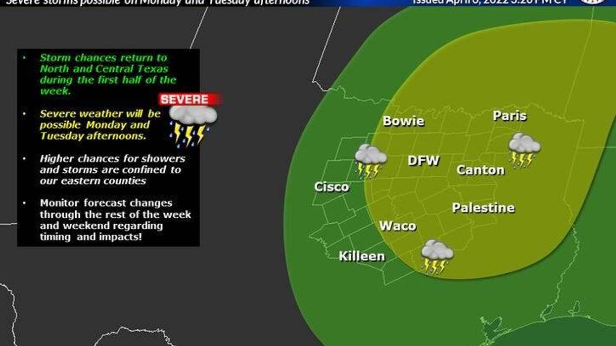
By Monday, the humidity will really start to increase, fueling the fire, as we shake hands with a dry line Monday and Tuesday. This will produce scattered showers and storms, some of these may become severe.
A cold front will come into the area on Wednesday, possibly sparking more storms. Cooler and windy weather will invade late in the week.
Afternoon highs this weekend through Wednesday will be in the low to mid-80s. Plenty of fuel for the fire for these storms so ignite.
________________________________
7-Day Headlines:
* Record high Wednesday: 77 degrees at DFW.
* Wind Advisory and Red Flag Warnings Thursday.
* Wind gusts to 40 mph Thursday.
* Below average temps to above-average temps.
* More wind this weekend into next week.
* Storm chances, possibly severe, return Monday and especially Tuesday.
_______________________________________________________
*Yest Rain: 0.00"; *Yest High: 77; Low: 57
*Today's Averages: High: 75; Low: 53
*Record high: 97 (1970); Record low: 31 (1971)
_______________________________________________________
*April rain: 1.33"; April surplus: + 0.74"
*2022 Rain: 5.56"; 2022 deficit
*Sunrise: 7:08 am; Sunset: 7:53pm
Thursday: *Wind Advisory* **Red Flag Warning** Mostly sunny, very windy and cool. High: Near 70. Wind: North 20-30, G40 mph.
 Forecast for Thursday and Friday in North Texas.National Weather Service
Thursday night: Protect plants. Clear and cool. Low: Low to mid-40s. Wind: NNW 10-15 mph.
Friday: Sunny, windy and cool. High: Near 70. Wind: North 15-25, G30 mph.
Saturday: Sunny, breezy and warmer. High: Low 80s.
Sunday: Mostly sunny, windy and warm. High: Mid 80s.
 Weekend forecast for North Texas.National Weather Service
Monday and Tuesday: Partly cloudy and warm. Chance of showers and storms. High: Low to mid 80s.
Wednesday: Sunny, turning windy and cooler by late afternoon. High: Low 80s.

LISTEN on the Audacy App
Sign Up and Follow NewsRadio 1080 KRLD

