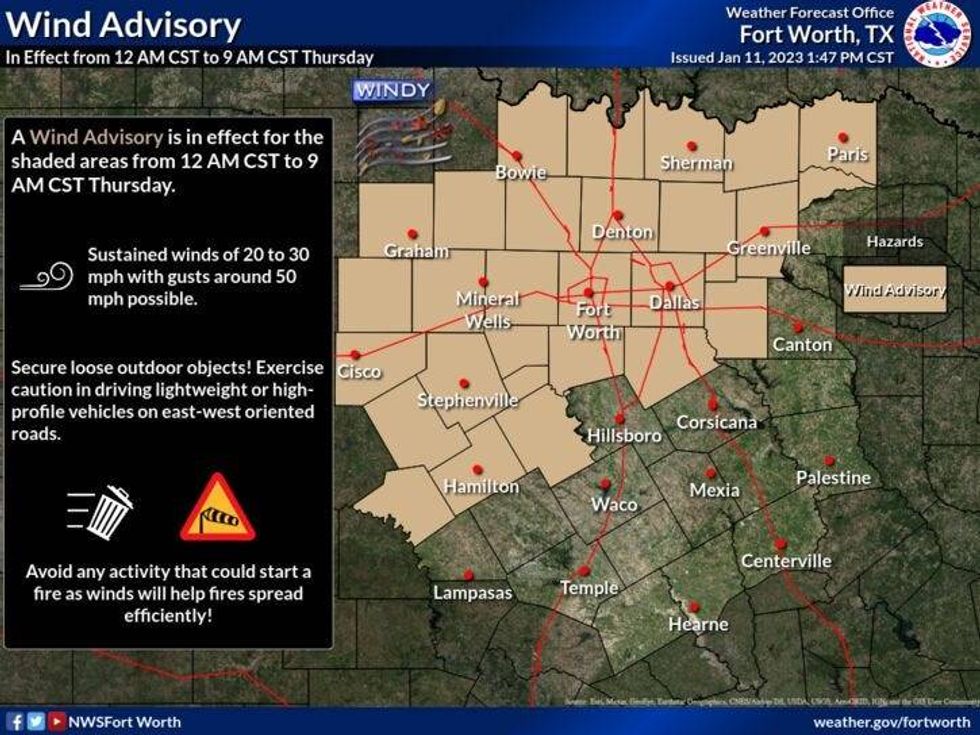
We're waking up to much cooler temperatures this morning, with a gusty north wind up to 45 mph. A Wind Advisory is in effect through 9:00 a.m. this morning.
Temperatures have fallen into the 40s across much of north Texas and readings won't warm up too much today. Plenty of sunshine with highs in the mid 50s. A good 30° cooler than yesterday.
 National Weather Service - Fort Worth
The wind slowly relaxes tonight, as temperatures fall into the upper 20s to mid 30s. Be sure to protect your plants and pets.
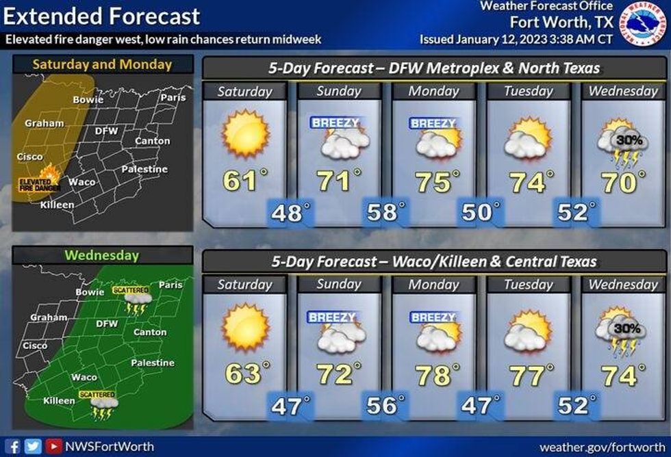
Friday looks to be sunny and cool with less wind. Afternoon highs will Top out in the mid 50s once again.
 National Weather Service - Fort Worth
Our weekend is looking nice with passing high clouds with a slow warm up. A south wind returns and will gust as high as 30 mph by Sunday. Afternoon highs on Saturday will reach the low 60s, pushing 70° by Sunday. Also, an elevated grass fire danger returns, especially west of I-35W.
MLK Day will be partly cloudy, windy, and a bit warmer. Afternoon highs will reach the mid 70s. Rinse and repeat for Tuesday, but with less wind.
Unfortunately, we've only measured a trace of rain this month, but we may finally see some on Wednesday. Showers and storms are a possibility, with highs in the upper 60s.
*Yest Rain: 0.00"; High: 85R; Low: 55
*Today's Averages: High: 56; Low: 36
*Record high: 83 (2000); Record low: 1 (1912)
*January rain: Trace; Deficit: 0.95"
*2023 rain: Trace; Deficit: 0.95"
*Sunrise: 7:31am; Sunset: 5:42pm
Today: * Wind Advisory through 9am* Sunny, windy and cooler. High grass fire danger. High: Mid 50s. Wind: NNW 20-30, G 45 mph(through noon). Gusts to 30 mph through the afternoon.
Tonight: Clear, less wind and chilly. Low: 28-34. Wind: NNW 10-15 mph.
Friday: Sunny and cool. Light winds. High: Mid to upper 50s. Wind: NNW 5 mph.
Saturday: A chilly start with a light freeze, then sunny, windy and cool. High: Low 60s.
Sunday: High clouds, windy and warmer. Grass fire danger. High: Near 70.
Monday: High clouds, windy and mild. Grass fire danger. High: Low to mid 70s.
Tuesday: Partly cloudy and mild. High: Low to mid 70s.
Wednesday: Mostly cloudy and continued mild. Possible showers and storms. High: Upper 60s.

LISTEN on the Audacy App
Tell your Smart Speaker to "PLAY 1080 KRLD"
Sign Up and Follow NewsRadio 1080 KRLD