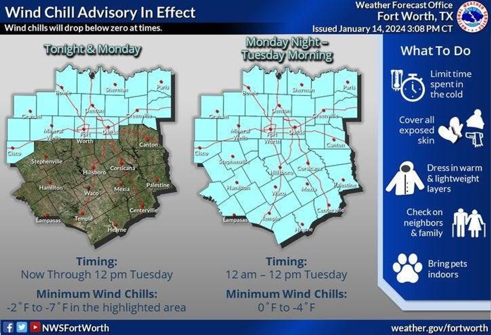
UPDATE: A Wind Chill Advisory and Hard Freeze Warning is in effect Monday night with increasing clouds and a low of around 7-11. The Wind Chill Advisory will go until Tuesday around noon and the Hard Freeze Warning is in effect until 10 am.
To make matters worse or even nicer for the kiddos, light snow will continue to fall through late morning as well. This is actually lake effect snow! Hard to believe right? We've also tied a record low this morning at 11° set back in 1905 as of 6:00 a.m. Wind chills are between -5 and -10°. Crazy!
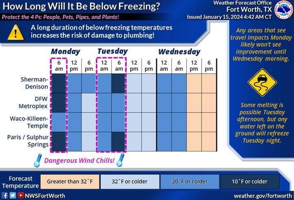
Got some good news for you, a warming trend will slowly evolve through Thursday and we'll safely be above freezing by noon Wednesday, but in the meantime we still have a lot of cold air to deal with and some slick roadways.
We're waking up to areas of light snow across North Texas. As of 6am, DFW Airport has measured 1.3" of snow so far, and it's still snowing. A light dusting has fallen across the rest of north Texas. Clearing and cold today with afternoon highs only into the mid 20s, with a north wind at 10 to 15 mph.
Tonight, clear, windy and cold with lows between 8 to 12°. The record is 11°. We may tie or break this record as well.
 NWSFortWorth
We'll finally get above freezing by Wednesday afternoon, Lows in the teens, with afternoon highs in the low to mid 40s. Great news! And the sun will be out as well!
It's even warmer on Thursday. Morning lows in the mid 30s with afternoon highs in the mid 50s! But, don't let your guard down. Another Arctic blast comes through the second half of Thursday, dropping temperatures to near 20 by Friday morning. Wind chills in the single digits! Sunny, windy and cold on Friday, with highs only in the mid 30s.
It stays cold into the weekend with morning lows in the 20s, afternoon highs in the upper 30s on Saturday, near 40 for Sunday. Another hard freeze is in the forecast for Friday, Saturday and Sunday mornings. Temperatures: Teens and 20s.
Our next rain chance arrives late Sunday into Monday. Right now, it looks like it'll be all liquid, but we'll have to watch late Sunday night to see if the temperatures will be flirting with the freezing mark. Please remember, I'm talking day 7 and 8am, things will change between now and then. We need to watch temperatures late SUnday night into Monday morning (NEXT WEEK).
Keep those faucets dripping until noon Wednesday and those cabinet doors open. Also, please keep your pets indoors as well! And.... don't forget to enjoy the weather when you can, it's the only weather you've got! Stay warm my friends!
____________________________________________
 NWSFortWorth
* DFW Airport reached 22 early yesterday. Tied record this Morning at 11 degrees.
* Wind Chill and Winter Weather Advisories until noon Monday.
* Light snow through noon today. Sun comes back out this afternoon
* Slick spots on roadways.
* Another record low Tuesday Morning.
* Sub-freezing weather through Wednesday noon.
* Another strong front Late Thursday.
* A cold weekend ahead!
_____________________________________________________
*Yest Rain: 0.00"; Yest High: 22 Low: 13
*Today's Averages: High: 56; Low: 36
*Record high: 81 (2020); Record low: 11 (1905)
__________________________________________________________
*January rain: 1.33"; Surplus: 0.14"
*2024 Rain: 1.33"; Surplus: 0.14"
*Sunrise: 7:31am; Sunset: 5:45pm __________________________________________________________
Today: * Winter Weather and Wind Chill Advisory until noon* ** Hard Freeze warning until 10am** Cloudy, breezy and cold. Light snow through noon, then decreasing clouds and cold. High: Low to mid 20s. Wind chills single digits. Wind: North 10-20 mph.
Tonight: *Wind chill Advisory* ** Hard Freeze Warning** Increasing clouds, windy and VERY cold. Low: 8-12 (Record is 11 degrees). Wind chills minus 5 to minus 10. Wind: North 15-25 mph.
Tuesday: Mostly sunny, breezy and cold. High: Upper 20s. Wind chills: Single digits. Wind: North 10-20 mph.
Wednesday: Sunny and a bit warmer. Low: Mid to upper teens; High: Low 40s.
Thursday: Sunny and tolerable, turning windy and colder. Low: Mid 30s; High: Low 50s.
Friday: Partly cloudy, windy and colder. Low: Near 20. High: Mid 30s.
Saturday: Sunny and chilly: Low: Low 20s; High: Near 40.
Sunday: Increasing clouds, continued cold. Precipitation late. High: Near 40
LISTEN on the Audacy App
Tell your Smart Speaker to "PLAY 1080 KRLD"
Sign Up to receive our KRLD Insider Newsletter for more news
Follow us on Facebook | Twitter | Instagram | YouTube