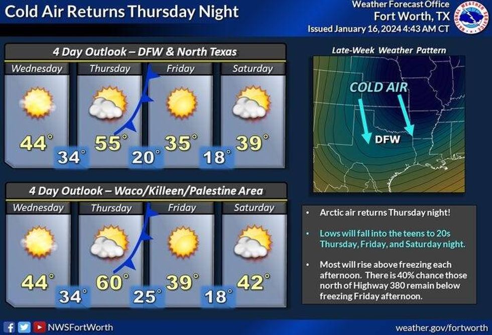
We will have about 30 more hours of sub-freezing temperatures before we finally get above 32° by noon tomorrow. Unfortunately, we're going back into the icebox late Thursday through Sunday, as another Arctic front is on the way. The good news is, that no precipitation is expected with the next cold front.
Bundle up! We're starting off between 10 and 14° this morning with wind chills at or slightly below zero. A Wind Chill Advisory is in effect until noon today. A Hard Freeze Warning expires at 10:00 a.m. It will be sunny, windy, and cold today with afternoon highs in the upper 20s. North winds will gust as high as 25 miles per hour this morning, 20 mph wind gusts this afternoon. Wind chills will be in the teens through the day.
The wind relaxes overnight under a clear sky, as temperatures fall into the mid to upper teens. Keep those faucets dripping and your pets indoors please.
Plenty of sunshine will dominate our weather on Wednesday, with a south wind gusting to 30 mph. This will warm temperatures up into the mid 40s by afternoon. However, it will be a chilly day with wind chills in the 30s.
 National Weather Service - Fort Worth
Thursday will be sunny and warmer, with afternoon highs in the low to mid-50s. Another arctic front will plow through North Texas on Thursday evening dropping temperatures back in the low 20s on Friday morning. Sunny, windy, and cold Friday afternoon highs ONLY in the mid-30s. Wind chills will be in the 20s.
Saturday will be sunny and cold. Morning lows will dip into the upper teens, with afternoon highs in the upper 30s.
 National Weather Service - Fort Worth
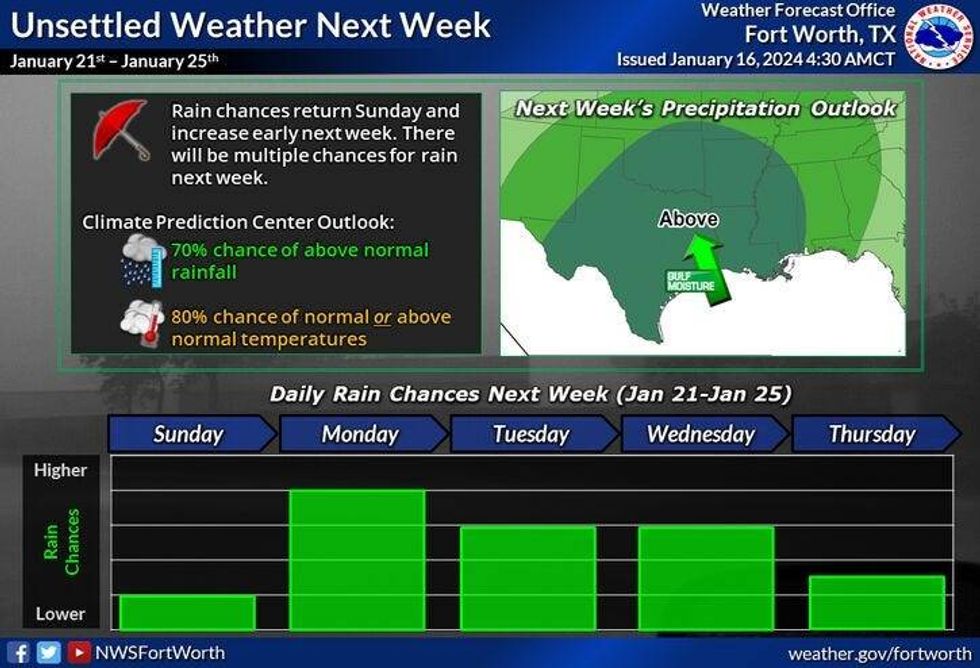
Clouds increase on Sunday but it will remain cold. Afternoon highs will level off in the low 40s. We might even see some light showers before midnight. Better rain chances arrive on Monday with highs back in the low 50s.
*Yest Rain: 0.01"; 1.5" of snow; Yest High: 26 Low: 11 (Tied the record)
*Today's Averages: High: 56; Low: 36
*Record high: 81 (1935); Record low: 11 (1930)
*January rain: 1.34"; Surplus: 0.07"
*2024 Rain: 1.34"; Surplus: 0.07"
*Sunrise: 7:31am; Sunset: 5:45pm
LISTEN on the Audacy App
Tell your Smart Speaker to "PLAY 1080 KRLD"
Sign Up to receive our KRLD Insider Newsletter for more news
Follow us on Facebook | Twitter | Instagram | YouTube