We've got some brutally cold air on the way - with a mini winter storm that will be arriving late Sunday into the first half of Monday. You still have time to winterize your home and vehicle, because the Arctic air won't arrive until late Saturday afternoon.
Last night some of you heard some noise, especially Dallas -> east, those storms are now in Louisiana and Arkansas.
A strong cold front has plowed through the area over the past few hours. Wind will gust as high as 45 mph through noon today. A Wind Advisory remains in effect until then. We're waking up the temperatures in the upper 20s to low 30s, with wind chills in the teens this morning. Bundle up and layer up! Temperatures will be much colder today with highs in the mid to upper 40s. Yesterday we reached 71°.
Clear and cold tonight with morning lows in the upper 20s to low 30s. The wind will relax and shift to the SSW at 5 to 10 mph.
Southerly winds will continue through mid-afternoon Saturday with plenty of sunshine. Highs will reach the mid to upper 50s. The bottom will then drop out towards dinner time. Temperatures will fall into the 20s by late Saturday evening, with wind chills in the single digits. Temperatures will stay below freezing Saturday night through early Wednesday afternoon.
 National Weather Service - Fort Worth
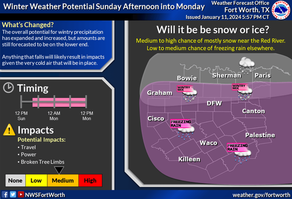
Our next weather change quickly evolves on Sunday. Clouds will increase through the day and we'll start to see some frozen precipitation on radar as soon as Sunday afternoon. The good news is the air will be very dry at the surface so precipitation will not reach the ground until Sunday night. That looks like the timing right now. Temperatures on Sunday will hover in the low to mid-20s.
The big question is, will the precipitation be reaching the ground when the Cowboys game lets out close to 6:30 p.m. on Sunday? As the evening evolves, this precipitation will eventually reach the ground, especially after midnight through mid-afternoon on Monday. It's still way too early to tell where the highest accumulations will be. It will be light, but it doesn't take much ice on the roadways to wreak havoc on travel.
 National Weather Service - Fort Worth
A Winter Weather Advisory will most likely be issued for Sunday night through Tuesday morning. Anything that does fall will stay on the ground until Wednesday.
Some of this will thaw Tuesday with sunshine but refreeze overnight into Wednesday morning. This event looks to have very light accumulations with it. I'll know a lot more on Sunday morning.
 National Weather Service - Fort Worth
Temperatures:
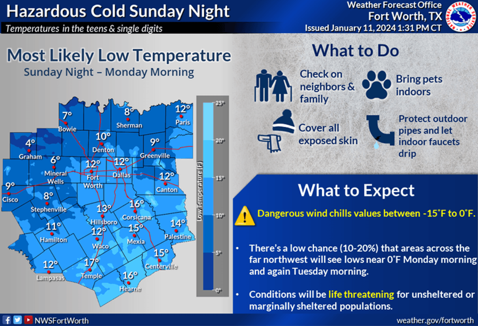
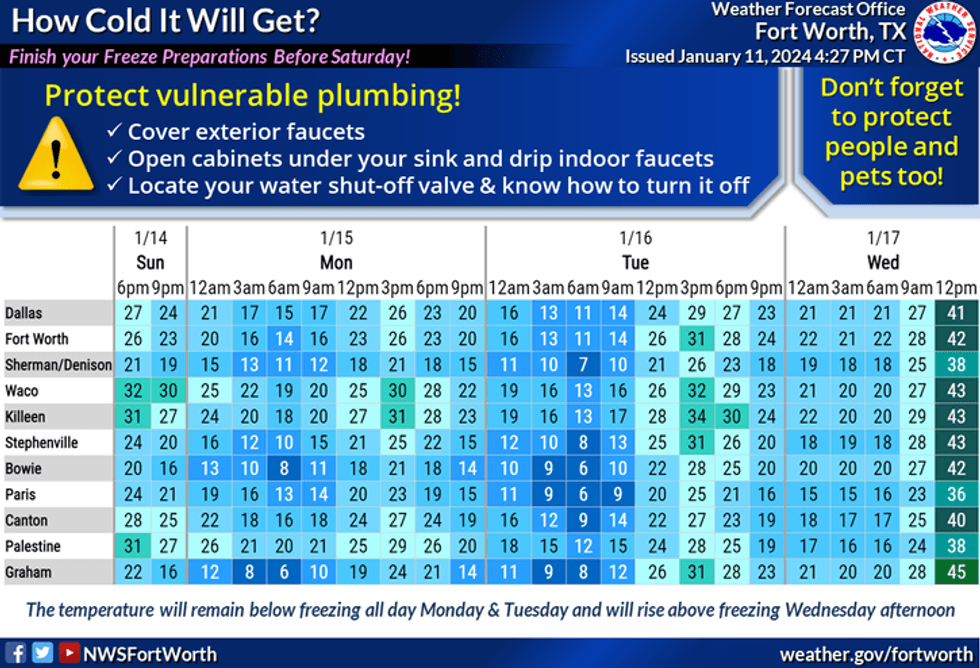
Monday's high near 20, low to mid 20s on Tuesday, low 40s on Wednesday, and mid 50s on Thursday. Morning lows will be in the single digits and teens Monday, Tuesday and Wednesday morning. At least the sun will be back out on Tuesday,
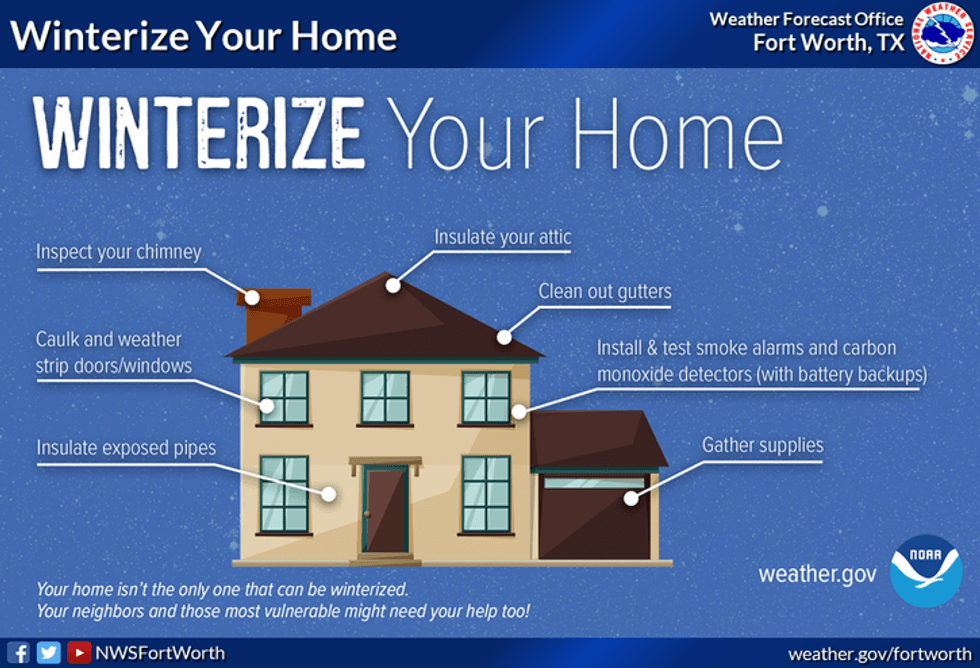
Prepare your home and vehicles now.
 National Weather Service - Fort Worth
*Yest Rain: 0.00"; Yest High: 71 Low: 38
*Today's Averages: High: 56; Low: 36
*Record high: 82 (2000); Record low: 1 (1912)
*January rain: 1.31"; Surplus: 0.36"
*2024 Rain: 1.31"; Surplus: 0.36"
*Sunrise: 7:31am; Sunset: 5:41pm
LISTEN on the Audacy App
Tell your Smart Speaker to "PLAY 1080 KRLD"
Sign Up to receive our KRLD Insider Newsletter for more news
Follow us on Facebook | Twitter | Instagram | YouTube