The National Weather Service issued a Severe Thunderstorm Warning for parts of North Texas through 2 a.m. Tuesday.
Morning clouds will give way to afternoon sunshine today with highs in the mid eighties. There's also a very slight chance for some late day showers and storms.
By tomorrow morning, a cold front will sag through the area. There is a slight chance for some storms along the front, but most of them will stay north along the Red River and into northeast Texas.
Decreasing clouds tomorrow windy and cooler. Highs will be in the mid seventies. A north wind will briefly bring drier air into the area.
 Partly cloudy. Isolated afternoon showers and storms.National Weather Service - Fort Worth
This front lifts back to the north late Tuesday night. There could be a few isolated storms as it does so.
Most of Wednesday looks to be OK with highs in the low to mid eighties. By Wednesday night and into Thursday morning, another cold front will move into north Texas. There's a pretty decent shot of showers and storms, a few could be severe.
The storm threat shifts south of DFW on Thursday. Highs will be in the upper seventies.
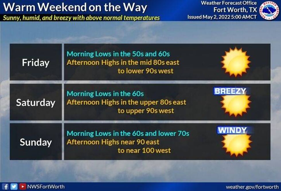
Warming temperatures will be our weather story Friday through the weekend with plenty of sunshine. Mid to upper 80s on Friday, low to mid 90s into the weekend. There'll be some triple digit heat off to the west of Fort Worth as well.
 Warming temperaturesNational Weather Service - Fort Worth
*Yest Rain: 0.00"; *Yest High: 85; Low: 58
*Today's Averages: High: 79; Low: 60
*Record high: 95 (1943); Record low: 49 (1978, 2013)
* May rain: 0.00"; May deficit: 0.15"
*2022 rain: 6.77"; 2022 deficit: 5.19"
*Sunrise: 6:40am; Sunset: 8:11pm
Today: Morning storms, Dallas -> east, afternoon sun. Windy and warm. Isolated late day storms. High: Mid 80s. Wind: South 15-25, G30 mph.
Tonight: Increasing clouds, windy and humid. Scattered storms, some severe along the Red River. Low: Mid to upper 60s. Wind: South 15-25, G30 mph.
Tomorrow: Morning scattered showers and storms, afternoon sun. Cooler. High: Mid 70s. Wind: North 10-20 mph.
Wednesday: Partly cloudy. Isolated afternoon showers and storms. Increasing storm chances after midnight. Some severe. High: Mid 80s.
Thursday: Morning storms, afternoon sunshine. High: Upper 70s.
Friday: Sunny and warmer. High: Upper 80s.
Weekend: Sunny, windy and hot! Highs: Low to mid 90s