You'll need your jackets this morning as temperatures have fallen into the forties once again. South winds are back as well, that will help warm temperatures into the upper sixties this afternoon. Gusts to 30mph are possible.
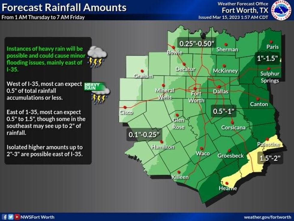
The wind picks up even more tonight into Thursday. Gusts to 45mph are possible. Increasing clouds tonight with scattered showers developing by daybreak. Morning lows will be near 60゚ .
 National Weather Service - Fort Worth
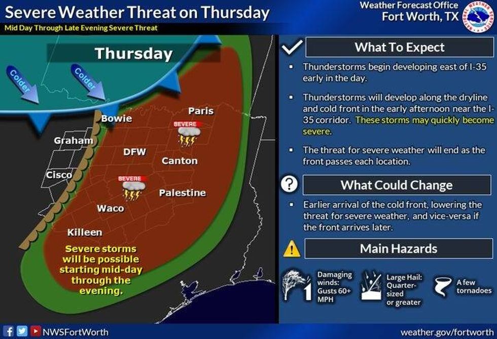
The big show starts tomorrow afternoon into the evening hours. Please stay weather aware from 4 PM to 10 PM across all of north Texas. All modes of severe weather are possible, but the greatest threats will be a large hail and damaging wind. Please remember, an isolated tornado can never be ruled out during a severe thunderstorm. Afternoon highs tomorrow will warm into the upper seventies.
 National Weather Service - Storm Prediction Center
A strong cold front will plow through here shortly before midnight ushering in much colder air. Wind gusts to 40mph are possible on Friday. Morning lows will dip into the upper thirties to low forties, with afternoon highs only warming into the low 50s.. Wind chills will be in the forties all day long.
 National Weather Service - Fort Worth
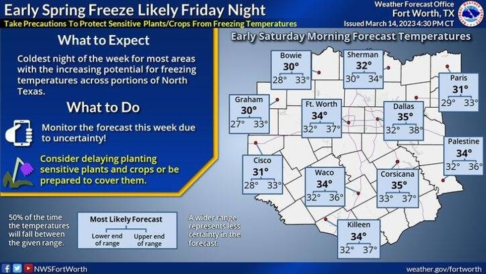
Protect your plants both Saturday and Sunday morning, as temperatures will drop between 30 and 36. A light freeze is expected in the rural areas away from DFW. Sunny and 58 for Saturday, increasing clouds low fifties for Sunday with a chance of rain by late evening.
 National Weather Service - Fort Worth
Rain will continue through Monday with afternoon highs only in the mid to upper forties! We clear out on Tuesday, with highs approaching 60゚. Our warm up will continue through the rest of the week.
*Yest Rain: 0.00"; Yest High: 63; Low: 39
*Today's Averages: High: 68; Low: 48
*Record high: 86 (1943); Record low: 28 (1912, 1913, 1954)
*March Rain: 1.35"; Deficit: 0.17"
*2023 Rain: 6.70"; Deficit: 0.17"
*Sunrise: 7:39am; Sunset: 7:36pm
Today: Partly cloudy, windy and warmer. High: Upper 60s. Wind: South 10-20, G30 mph.
Tonight: Increasing clouds, windy and mild. Scattered showers towards daybreak. Low: Upper 50s. Wind: South 20-30, G45mph.
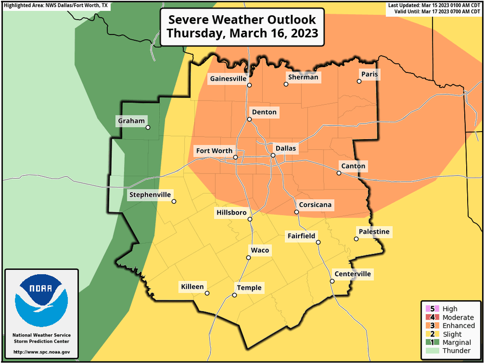
Tomorrow: Mostly cloudy, VERY windy and warm. Morning showers, then Scattered severe storms by afternoon and evening (4pm-10pm). Threat Level: 3 out of 5. Storm Threats: Large hail, damaging wind and isolated tornadoes. High: Upper 70s. Wind: South 20-30, G45 mph.
St. Patrick's Day: Morning showers, afternoon sun. VERY windy and MUCH cooler. High: Low 50s.
Saturday: Morning freeze away from DFW. Partly cloudy and cool. High: Mid 50s.
Sunday: Increasing clouds, continued chilly. Chance of a chilly rain late. High: Low 50s.
Monday: Cloudy and chilly. Chance of rain. High: Upper 40s.
Tuesday: Decreasing clouds and a tad warmer. High: Near 60.

LISTEN on the Audacy App
Tell your Smart Speaker to "PLAY 1080 KRLD"
Sign Up to receive our KRLD Insider Newsletter for more news