


AFTERNOON UPDATE: The Winter Storm Warning has been expanded into more in East Texas, but remains in effect for the Metroplex up to the Red River. A Winter Weather Advisory is in effect for western North Texas and much of Central Texas.
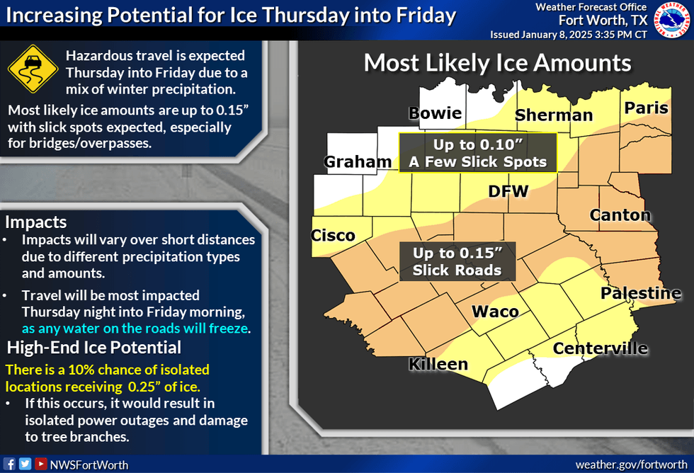
There is an increased potential for ice accumulations across North & Central Texas, with a 10% chance of isolated locations receiving up to a quarter inch of ice. The probability is low, but if this occurred there would be more significant travel impacts, as well as isolated power outages and damage to trees.
Timing is still on track, with precipitation beginning Thursday morning around 4-6 a.m. in our western counties, spreading across the I-35 corridor in the 6-9 a.m. period, and into our eastern counties after that. The heaviest precipitation will be from Thursday afternoon into Friday morning.
Precipitation will be mostly out of North and Central Texas by daybreak Friday morning
Along/north of I-20 including the Metroplex, precipitation is expected to start as a mix of sleet and rain on Thursday morning, then transition to a mix of rain, sleet, snow, and even a little freezing rain during the day Thursday. Some areas may transition to rain for parts of Thursday afternoon. South of I-20, mainly a cold rain is expected during the day Thursday, but a little sleet or freezing rain could mix in as well. During Thursday evening, most areas except for far southern Central Texas will change to a snow/sleet mix, then to all snow by midnight
Snow and ice totals
North of I-20 will have two to five inches of snow with up to 1/10" of ice possible; isolated higher snow amounts of up to eight inches possible near the Red River. Northeast of the Metroplex near I-20 will have around one to four inches of snow/sleet, with up to 0.15" of ice. Central Texas (north of a Killeen to Palestine line) will have up to one inch of snow and up to 1/10" of ice possible. Central Texas (south of a Killeen to Palestine line) will have just rain expected,
Impacts
Travel conditions will be mostly okay during the Thursday morning rush hour, but deteriorate through the day on Thursday. Worst travel impacts are expected from late Thursday afternoon into Friday morning. Untreated roads and bridges/overpasses will become hazardous by Thursday evening. Any water on roads that remain "drivable" Thursday will freeze overnight and create hazardous conditions Friday morning. Roads will improve some on Friday, but again, any lingering water will refreeze on roads Friday night causing travel issues into Saturday morning. More significant melting will occur on Saturday and Sunday. Impacts will vary greatly over short distances, especially near/north of I-20, due to differing precipitation types and amounts.
Remaining uncertainties
Temperatures hovering around the freezing mark will dictate where the rain-to-wintry, mix to a snow transition zone will occur, which currently looks to be near I-20 and across the Metroplex. Confidence has increased on snow totals, but some areas see higher amounts of up to eight inches in northeastern North Texas near the Red River. Any ice and snow accumulations in Central Texas could be less if warmer temperatures occur.
 National Weather Service
Winter Storm Warning is still in effect for central and eastern portions of North Texas. We will likely be adding a few counties to the Winter Weather Warning, especially in the east, with an advisory for much of the remainder of the watch area.
Precipitation still begins Thursday morning around 4-6 am in the west, spreading across the I-35 corridor in the 6-9 am period, and involving the rest of the forecast area throughout the day. Peak timing will be Thursday evening into Friday morning. Precipitation will mostly be out of the region prior to daybreak Friday morning. Much of the precipitation will start off as a mix of sleet and rain; will likely see a mix of rain, sleet, snow and even a little freezing rain during the day Thursday along/north of I-20, with some areas (including Metroplex) seeing mainly rain for periods of time on Thursday afternoon.
We will see mostly a cold rain South of I-20 during the day Thursday, mixed with a little sleet and even a little freezing rain as well. Ther will be a large-scale transition to mainly a snow/sleet combination after sunset Thursday, from Red River down to I-20. Precipitation ends as snow after midnight. Daytime temps have lowered slightly for Thursday; ranging from near freezing along Red River; lower/mid-30s Metroplex/I-20 corridor; mid-30s farther south on Thursday night/Friday morning lows upper 20s Red River to lower 30s south of I-20.
Snow and ice totals
North of I-20: Most likely snowfall totals will remain between 2-4 inches. Areas north and northeast of the Metroplex: There is still greater potential for isolated higher amounts of up to 8 inches in any heavier snow bands Thursday night. Specific locations of any snow bands and higher-end totals are difficult to pin down at this time.
Near I-20: Most likely snowfall/sleet totals between 1-2 inches. Light ice accumulations up to 0.10 inches are possible, but the probabilities are low.
Central Texas: Minor snow and ice accumulations may occur in portions of Central Texas.
Impacts
Travel (both road and air) conditions will mostly be ok during the Thursday morning rush hour (save a few slick spots), but will gradually deteriorate throughout the day on Thursday. Travel impacts should increase from late Thursday afternoon into the evening, peaking by early morning Friday. Untreated surface roads will become difficult to use and some elevated bridges and overpasses may become impassable by Thursday evening.
Impacts to roadways may linger into the weekend. Some melting may occur on Friday afternoon. Any water left on roadways will refreeze overnight into Saturday morning, causing slick spots.
What we are still uncertain about
Near-surface temperatures during the event, which will dictate where snow-wintry mix and wintry mix-cold rain transition zones, will be located. We've lowered the temps for Thursday, but even at freezing, how much sticks will depend on precipitation intensity and the impacts of traffic and road treatments.
Exact snow amounts. Confidence is increasing in 1-4" amounts in most areas, with some isolated totals up to 8 inches in northeastern North Texas, north/northeast of the DFW Metroplex.
Potential ice accumulations in portions of Central Texas. Some areas may see accumulations up to 0.10 inches, but this will largely depend on temperatures.
A Winter Storm Warning will take effect Thursday at 6 a.m. and remain in place until Friday at 12 p.m. for the Dallas-Fort Worth area and points north and northeast. Accumulating wintry precipitation is forecast to begin Thursday morning.
Wednesday morning, temperatures were in the mid to upper 20s with the high expected to reach 40 degrees with a mix of sun and clouds.
Wednesday night, cloud cover will increase, and temperatures will drop to the upper 20s to near 30 degrees.
By daybreak Thursday, a large area of wintry mix will approach from the southwest. Waves of freezing rain, sleet, and snow will impact the area through late morning. By afternoon, some of this wintry mix will transition to a rain-snow mix south of DFW. Temperatures will hover near or slightly above the freezing mark, and road conditions will be hazardous across Dallas and Fort Worth, with better conditions south and worse conditions north.
By evening and overnight into noon Friday, the wintry mix will transition to all snow from west to east. Additional snow accumulations are possible, and new snow accumulations will occur south of Dallas and Fort Worth.
Temperatures will fall to the upper 20s to low 30s on Friday morning. Based on the current data, 2-4 of the wintry mix is possible across Dallas and Fort Worth, with higher totals north towards the Red River and lower totals south towards Waco and Palestine.
Precipitation will end from west to east by early Thursday afternoon, with brightening skies. Very little sunshine will be seen, except in areas west and northwest of DFW. Afternoon highs will reach the mid to upper 30s.
Road conditions will deteriorate rapidly in the Winter Storm Warning area on Thursday during the day. These hazardous road conditions will spread farther south of DFW overnight Thursday into Friday morning. Travel is discouraged in the morning areas starting Thursday morning and will continue to be discouraged until Friday afternoon when roads will become slushy.
Unfortunately, any residual moisture left on the roads Friday night into Saturday will refreeze as temperatures drop to the low 20s.
Plenty of sunshine is expected this weekend, with afternoon highs in the mid to upper 40s. Morning lows will be slightly below freezing, so patchy ice may continue each morning.
Please note that winter weather accumulations will be adjusted as we get closer to the onset of precipitation Thursday morning and will continue to be tweaked during the storm as radar trends dictate.
7-Day Headlines
DFW reached 39 degrees Tuesday.
*Winter Storm Warning (DFW -> North): Thursday 6am – Friday noon.
Freezing Rain/Sleet/Snow for much of north Texas Thursday into noon Friday
2-4 inches likely north of I-20 to Highway 380, 4 inches along & north of Highway 380.
Temps hover near freezing on Thursday.
Hazardous travel through Friday afternoon in the Warning area
Clearing, highs in the 40s this weekend. Melting occurs.
___________________________________________
*Tuesday Rain: 0.00"; Tuesday High: 39 Low: 25
*Wednesday's Averages: High: 56; Low: 36
*Record high: 88 (1969): Record low: 11(1942. 1976)
_________________________________________________________
*January Rain: Trace; Deficit: .
*2025 Rain: Trace; Deficit:
*Sunrise: 7:32am; Sunset: 5:39pm
_________________________________________________________
Wednesday: Partly cloudy and cold. High: Mid to upper 30s. Wind: North 5-10 mph.
Wednesday night: Increasing clouds and cold. Low: Near 30. Wind: North 5 mph.
Thursday: **Winter Storm Warning** starts at noon. Cloudy and cold. A widespread wintry mix. Accumulations: 1" to 3". Heaviest Hwy 380 -> north. Tricky road conditions. High: Low to mid 30s. Wind: North 5 mph.
Tomorrow night: ** Winter Storm Warning** Cloudy and cold. Wintry mix to all snow. Accumulations 1"to 3+". Heaviest Hwy 380 -> north of DFW. Low: Near 30.
Friday: **Winter Storm Watch until noon** Morning light snow, moving out by early afternoon. Accumulations: 1". High: Mid to upper 30s.
Weekend: Mostly sunny and chilly. Highs: Mid to upper 40s.
Monday and Tuesday: Mostly sunny and cool. Highs: Near 50.
LISTEN on the Audacy App
Tell your Smart Speaker to "PLAY 1080 KRLD"
Sign Up to receive our KRLD Insider Newsletter for more news
Follow us on Facebook | Twitter | Instagram | YouTube


