


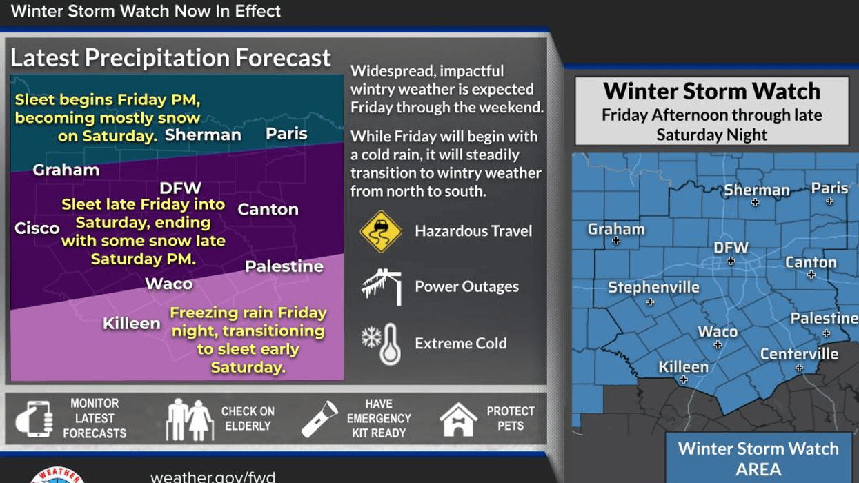
Enjoy today and tomorrow, as the weather is expected to deteriorate significantly. A winter storm watch has been issued from noon Friday to 6:00 a.m. Sunday, with rain, freezing rain, sleet, and snow in the forecast. Travel advisors anticipate hazardous road conditions, and necessary precautions should be taken.
Good morning, and welcome to Wednesday. We are experiencing a calm morning with cloudy skies and temperatures ranging from the upper 40s to low 50s. Some areas received passing showers overnight, which have since moved eastward. We can expect slow clearing from west to east today, with high temperatures reaching the low 60s.
A weak front will move into the area later today and stall near Interstate 20, resulting in a temperature range of 40°F north of the front to 52°F south of the front by tomorrow morning. No precipitation is expected with this front, which will lift northward tomorrow, allowing temperatures to rise into the low 60s with increasing cloud cover.
On Friday morning, a brisk north wind will signal the arrival of an arctic front, bringing widespread rain that will persist throughout the day. Temperatures will drop from the 50s in the morning to the 40s by noon and the 20s to low 30s by evening, with areas northwest of Dallas and Fort Worth falling below freezing first.
The freeze line will then move south and east, with rain transitioning to freezing rain and eventually sleet from northwest to southeast through the overnight and Saturday morning. Temperatures will plummet and range between 15 and 20 degrees by daybreak, with north winds gusting up to 25 mph and wind chills near zero.
Saturday will be particularly miserable, with temperatures struggling to reach 20°F and widespread moderate to heavy sleet throughout the day. Wind chills will remain near zero, and the sleet will eventually transition to accumulating snow late Saturday into Sunday morning.
By Sunday morning, temperatures will have fallen into the teens again, with morning snow and afternoon flurries expected. Some sunshine may break through the clouds, with afternoon highs potentially reaching the mid-20s. Winter weather advisories may be issued for late Sunday through Tuesday morning due to the sleet and snow pack on roadways.
Morning lows Monday and Tuesday will dip into the single digits, with highs on Monday near 30°F and finally rising above freezing to the mid-30s on Tuesday.
For live updates, please tune into NewsRadio 1080 KRLD throughout this event. Additionally, consider downloading the AUDACY app to access our content 24/7. This will be particularly useful in case of power outages.
Thank you for following my page, listening to KRLD, and making the most of the weather when possible. It's essential to stay informed and prepared for the impending winter storm.
7-Day Headlines:
* DFW Airport reached 53 yesterday.
* Seasonable temperatures through Thursday.
* Winter Storm Watch Friday noon – Sunday 6am.
* Friday morning Arctic cold front. Cold rain through the afternoon.
* Rain to freezing rain to sleet Friday evening.
* Lots of accumulating sleet to snow (late) on Saturday.
* Morning Sunday snow, then flurries throughout the day.
* Sub freezing temperatures Friday late afternoon through Tuesday afternoon.
*Yest Rain: 0.00"; Yest High: 53; Low: 29
*Today's Averages: High: 57; Low: 36
*Record high: 79 (1909, 1952); Record low: 7 (1935)
*January Rain: 0.01"; Deficit:
*2026 Rain: 0.01"; Deficit:
*Sunrise: 7:29am; Sunset: 5:51pm
Wednesday: Cloudy, with a few morning showers (East of DFW), then decreasing clouds by afternoon. High: Mid Low 60s. Wind: Variable 5-10 mph.
Wednesday night: Partly cloudy and cool. Stalled cold front. Low: 40-52. Wind: Variable 5-10 mph.
Thursday: Increasing clouds and seasonable. High: Low 60s. Wind SE 5-10 mph.
Friday: Morning Arctic cold front, turning windy and MUCH colder. Morning rain, changing to freezing rain mixed with sleet by late afternoon and evening. High: Low 50s early, then sharply falling temperatures. Below freezing by dinner time.
Friday night: Cloudy, windy and VERY cold. Widespread wintry mix. Low: 15-20. Wind chills: Near zero.
Saturday: Cloudy, windy and VERY cold. Widespread accumulating sleet, changing to accumulating snow by evening. High: Near 20. Wind chills: Near zero.
Saturday night: Cloudy, less wind but pipe bursting cold. Accumulating sleet changes to accumulating snow. Lows: Teens. Wind chills near zero.
Sunday: Morning accumulating snow, then snow flurries throughout the day. High: Low to mid 20s.
Monday: A bitter cold morning, then mostly sunny and continued cold. Low: Single digits; High: Near 30.
Tuesday: Another pipe bursting morning, then mostly sunny and cold. Low: Single digits; High: Low to mid 30s.
LISTEN on the Audacy App
Tell your Smart Speaker to "PLAY 1080 KRLD"
Sign Up to receive our KRLD Insider Newsletter for more news
Follow us on Facebook | Twitter | Instagram | YouTube


