10 AM SUNDAY FORECAST UPDATE:
7-Day Headlines:
* Winter Storm Warning today and Monday.
* Blizzard conditions today through Monday morning.
* Heavy snow this afternoon through early Monday.
* Record breaking cold next week!!
* Morning lows close Tuesday near to zero…or below!
* Another winter storm late Tuesday into early Thursday.
_____________________
*Yesterday's High: 33; Low: 20
*Today's Averages: High: 60; Low: 39
*Records: High: 85 (1996); Low: 15 (1905, 08, 36) ______________________
*Yesterday's rain: Trace; Feb. rain: 0.01"; Feb. deficit: ">
*2021 Rain: 0.86"; 2021 Deficit: ">
*Sunrise: 7:11am; Sunset: 6:14pm
______________________
*Winter Storm Warning today through 6pm Monday*
Today: *Winter Storm Warning* Cloudy, windy and cold. Heavy snow and blowing snow. Near whiteout conditions. Heaviest this afternoon through midnight…light snow during predawn hours. Accumulations 2"-4".High: Upper teens, falling into the single digits. Wind: NNE 15-25, G35.
Tonight: Snow and blowing snow. Accumulations 2"-4". Windy and pipe-burstin'COLD!! Low: Zero to 5 degrees. Windchills: Minus 10 to minus 20! Wind: NNE 15-25, G35 mph.
Monday: Chance of morning snow and blowing snow. Partial clearing by afternoon. Windy and BITTER COLD! High: Low teens. Wind: NNE 15-25, G30.
Tuesday: Partly cloudy early, increasing clouds late day. Record breaking cold! Chance of wintry mix by late evening. Low: Minus 5 to zero; High: Mid teens.
Wed: Cloudy and continued cold. Storm #2 arrives. Chance of accumulating snow. Low: Low teens; High: Upper teens.
Thursday: Cloudy and cold. Snow ending by afternoon…flurries through the evening. Windy and COLD! Blowing snow. Low: Mid teens; High: Near 20.
Friday: Sun comes back out!! But, staying cold! Low: 5-10; High: Mid to upper 20s.
Weekend: Warming up and thawing out! Plenty of sunshine!
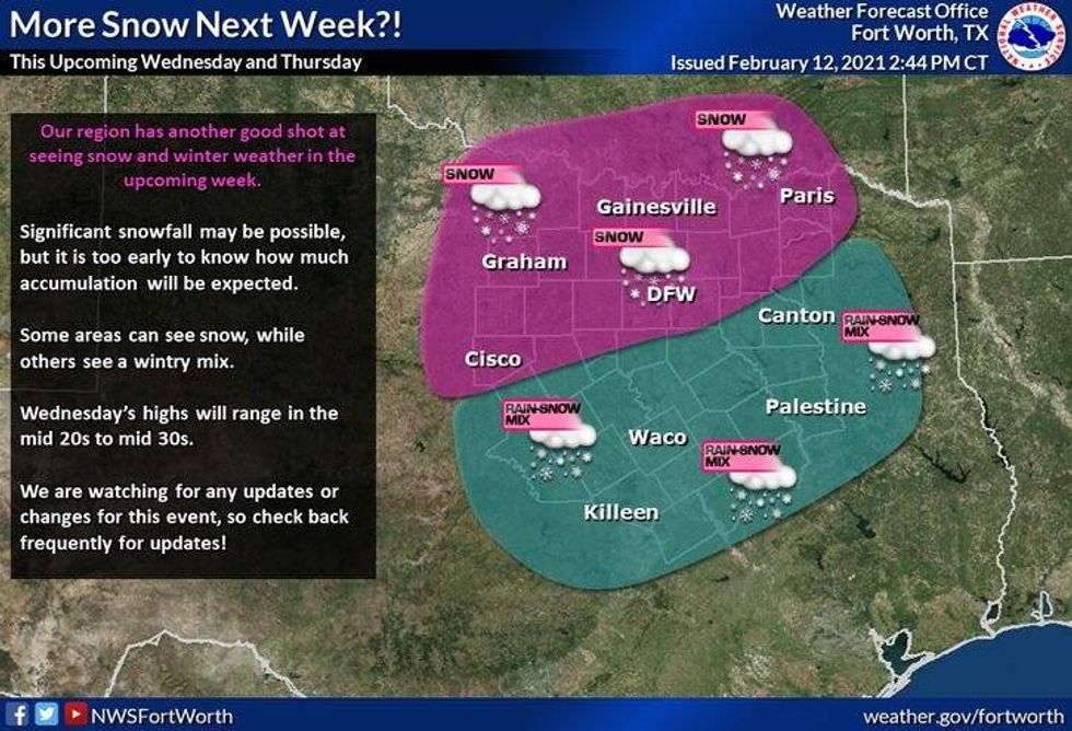
The heaviest snow will fall Sunday evening through the overnight and end from west to east Monday morning. Most data suggests anywhere between 3 to 5" of snow, but this may be tweaked up or down depending on where the heaviest bands set up. Factor in the 30 mph wind gusts, we'll be approaching blizzard like conditions across north Texas overnight into Monday morning. Blowing snow during the event will reduced visibilities to less that a quarter mile. Road conditions will deteriorate through the day on Sunday making roads virtually impassable by Monday morning.
 NWS
NWS
The snow's not going anywhere, because temperatures will be in the twenties during the snow event, dropping into the teens by Monday morning. Windchills will be close to 0 or below.
We will get a break in the precipitation on Monday and most in Tuesday before storm system number two impacts our weather Wednesday into early Thursday morning. This will most likely prompt another Winter Storm Watch to be issued by Monday aft/evening. Heavy additional snowfall is possible with storm number two.
Temps Tues through Thurs will stay in the teens for highs, with morning lows in the single digits in some areas, especially if we clear out at any time during the overnight's. This will be record breaking cold!
We'll see an end to the snow by Thurs aft, but it will remain cold into Fri. We'll finally get above freezing by Saturday.
 NWS
NWS