


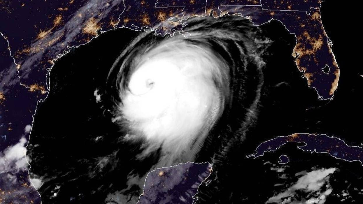
The National Hurricane Center now says Hurricane Laura will have top winds of 130 miles per hour as it approaches the Louisiana - Texas line.
"On the forecast track, Laura should approach the Upper Texas and southwest Louisiana coasts on this evening and move inland near those areas tonight or Thursday morning," according to the official forecast.
As of 7:00am maximum sustained winds had increased to near 115 mph, already making Laura a Category 3 storm.
"Laura is forecast to become a category 4 hurricane today, and is expected to be a major hurricane at landfall. Rapid weakening is expected after Laura makes landfall."
That means Laura would be a Category 4 as it nears the coast, pushing a wall of water that surges ashore near the eye forecast to be 15 feet deep... deeper than the peak of an average one story home.
The Hurricane Center is also forecasting 15 inches of rain where Laura roars ashore.
That will be in the Lake Charles, Louisiana area.
In the New Orleans area, rainfall is forecast to be one to four inches. Surge in Southeast Louisiana will be four to seven feet along the coast west of the Mississippi River and two to four feet from the River to the Mississippi - Louisiana line and in Lake Pontchartrain.
HAZARDS AFFECTING LAND
STORM SURGE: The combination of a dangerous storm surge and the tide will cause normally dry areas near the coast to be flooded by rising waters moving inland from the shoreline. The water could reach the following heights above ground somewhere in the indicated areas if the peak surge occurs at the time of high tide...
STORM SURGE:
The combination of a dangerous storm surge and the tide will cause normally dry areas near the coast to be flooded by rising waters moving inland from the shoreline. The water could reach the following heights above ground somewhere in the indicated areas if the peak surge occurs at the time of high tide...
HAZARDS AFFECTING LANDSea Rim State Park to Intracoastal City including Sabine Lake and Calcasieu Lake...10-15 ftIntracoastal City to Morgan City including Vermilion Bay...8-12 ftPort Bolivar to Sea Rim State Park...6-9 ftMorgan City to Mouth of the Mississippi River...4-7 ftSan Luis Pass to Port Bolivar...3-5 ftGalveston Bay...3-5 ftMouth of the Mississippi River to Ocean Springs including Lake Borgne...2-4 ftLake Pontchartrain and Lake Maurepas...2-4 ftFreeport to San Luis Pass...2-4 ftThe deepest water will occur along the immediate coast near and to the right of the landfall location, where the surge will be accompanied by large and destructive waves. This storm surge could penetrate up to 30 miles inland from the immediate coastline in southwestern Louisiana and far southeastern Texas.Surge-related flooding depends on the relative timing of the surge and the tidal cycle, and can vary greatly over short distances.
RAINFALL: From this afternoon through Friday, Laura is expected to produce rainfall totals of 5 to 10 inches, with isolated maximum amounts of 15 inches across portions of the northwestern Gulf Coast from western Louisiana to far eastern Texas, and northward into much of Arkansas. Over the lower to middle Mississippi Valley from central Louisiana into western Tennessee and Kentucky, and southeastern Missouri, 2 to 4 inches of rainfall with isolated totals of 6 inches are expected. This rainfall will cause widespread flash and urban flooding, small streams to overflow their banks, and minor to isolated moderate river flooding.By late Friday into Saturday, portions of the Tennessee and Ohio Valley could see 2 to 4 inches with locally higher amounts as tropical moisture from Laura moves through the region. This rainfall could lead to localized flash and urban flooding along small streams.WIND: Hurricane conditions are expected in the hurricane warning area tonight and Thursday. Tropical storm conditions are expected to reach the coast in the hurricane warning area late today or tonight, and are expected in the tropical storm warning area tonight and Thursday.Hurricane-force winds and damaging wind gusts are also expected to spread well inland into portions of eastern Texas and western Louisiana early Thursday.TORNADOES: A few tornadoes are expected this evening through tonight over Louisiana, far southeast Texas, and southwestern Mississippi. The risk for a few tornadoes should continue into Thursday across Louisiana, Arkansas, and western Mississippi.SURF: Swells produced by Laura are affecting the U.S. Gulf coast from the west coast of Florida to Louisiana and are expected to reach the coast of Texas and northeastern Mexico today. These swells are likely to cause life-threatening surf and rip current conditions. Please consult products from your local weather office.
LISTEN NOW on the RADIO.COM AppFollow RADIO.COMFacebook | Twitter | Instagram


