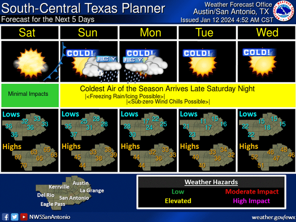
AUSTIN (Talk1370.com) -- Forecasts are continuing to indicate an arctic blast is set to hit Central Texas in just over 48 hours - with those forecasts trending colder, faster, and with potentially more moisture as of Friday morning.
Friday morning's update from the National Weather Service is now forecasting the arctic front to move through Central Texas late Saturday evening, sending temperatures down into the upper 20s by Sunday morning. Sunday's forecast low for Austin-Mabry is 27 degrees.
Temperatures Sunday afternoon will struggle to reach the mid 30s, as a chance of patchy freezing drizzle and freezing rain could begin as early as mid-afternoon with chances increasing into the evening and overnight hours.
Overnight Sunday into Monday morning, lows are expected to fall into the lower 20s, with a forecast low of 22 degrees for Austin.
 NOAA/National Weather Service Austin-San Antonio
While any precipitation chances are currently expected to come to an end on Monday morning, high temperatures by Monday afternoon are barely expected to reach into the lower 30s, before the deep freeze really sets in. Tuesday and Wednesday mornings are both calling for forecast lows of 15 degrees in Austin, with wind chill values down into the single digits to near zero. Parts of the Hill Country could see wind chill values below zero.
Right now, the forecast is calling for light accumulations of up to a few hundredths of an inch - but even that has the potential to cause some significant travel issues, particularly on bridges, overpasses, and other elevated surfaces.
TxDOT crews were mobilizing Friday morning to begin their pre-treatment efforts across the area - using a brine saltwater solution that helps to prevent ice from bonding on the roadway surfaces. Crews will focus on the heaviest traveled roadways and then work to treat secondary roadways as possible.
While temperatures will finally get into the upper 40s by Wednesday afternoon, another shot of arctic air is set to approach the area on Thursday.