


CHICAGO (WBBM NEWSRADIO) -- Wet weather that moved into the Chicago region Sunday night into Monday morning is expected to stick around intermittently for most of the week.
Moderate to heavy rain, along with a few thunderstorms, moved into the area overnight and continued through Monday's morning commute, according to the National Weather Service.
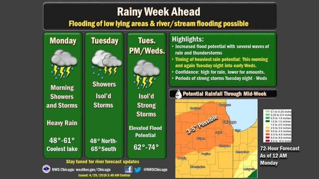
Rain continues this morning. There are still embedded thunderstorms, along with some pockets of moderate to heavy rainfall. The heavy rainfall will lead to ponding of water on roads, and perhaps some minor flooding. Use caution this morning for the commute. pic.twitter.com/hDYYmvWtzt
— NWS Chicago (@NWSChicago) April 29, 2019While the rain is expected to taper off through Monday afternoon, more showers and isolated thunderstorms are expected Tuesday, the weather service said. The rain could continue through Tuesday night and Wednesday morning.
The storms could become more severe on Tuesday evening and again on Wednesday afternoon, according to a hazardous weather outlook from the weather service. Stronger downpours could cause ponding of water and localized flooding.
A wet start to the week is expected with a couple rounds of rain expected through mid-week. Rain begins tonight across the area and continues into early Monday afternoon. Then, another round of heavy rain is set to arrive Tuesday night. pic.twitter.com/2jpolB4nJl
— NWS Chicago (@NWSChicago) April 28, 2019A chance of showers is also predicted for Thursday and Thursday night, according to the weather service. High temperatures are expected to remain in the low 50s through Tuesday before rising into the 60s on Wednesday and Thursday.
Things should clear up by the end of the week, with forecasters predicting a mostly sunny Friday with a high near 60 degrees.
(Source: Sun-Times Media Wire & Chicago Sun-Times 2019. All Rights Reserved. This material may not be published, broadcast, rewritten, or redistributed.)


