Despite Chicago's rich and complex history, there is still a lot unknown about its neighborhoods.
"That parking lot maybe that's on the corner in your neighborhood didn't always used to be a parking lot, most likely," said Parker Otto, University of Chicago graduate and Graduate Research Project Manager in the Chicago Studies program. "Maybe it was a five-story, mixed-use building. Maybe it had beautiful architecture."
He said these types of details and stories about Chicago's neighborhoods are what he's been uncovering with the Chicago Urban Heritage Project, which he launched last year.
He said the project grew from the Chicago Centuries Project, an initiative that studied the evolution of the neighborhoods around UChicago's campus. It focused on the 55th and 63rd Street corridors between 1920 and 2020.
Student researchers collected data about every building on each neighborhood block and used 20th century Sanborn Atlases and historic aerial photos to digitally represent their findings.
 Sanborn volumes in the UChicago Library Map Collection Reading Room.Jason Smith
At first, Otto said, students were digitally mapping by hand, which he said was a very long and tedious process.
"I wanted to do it a way faster way," he said. So, he spent many nights staying up teaching himself Python, a popular programming language.
"I rewrote it to be a more computational workflow, using math to look at the different pixels on the different map sheets," he said. "It brought the process down to under two minutes from two hours."
Otto graduated in 2024 but still leads the project. He said the goal is to turn these century-old insurance atlases into interactive digital archives of the city's built environment.
"We're bringing that into a web format, so you can just go on your phone, go to our Urban Heritage website, click on a building and see exactly what it was used for, what it was made of, what its name was, anything notable about the building," he said. "It's a really great tool for people to learn about their pasts."
The Chicago Urban Heritage Project launched with its first cohort of undergraduate researchers last spring.
Sophia Liu, a second-year public policy major, said the students' work primarily consists of running Otto's Python model to digitize building footprints, going through those maps and attaching data to them.
"All of the maps have a huge wealth of information, from the number of stories in the building, what it's used for, what it's made out of. Sometimes there's a name, sometimes there's other little notes," Liu said. "We manually put in every single building use, floor, etc. And then by the end, we have this interactive, clickable footprint."
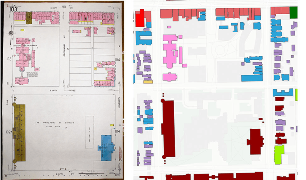 A scan of an original Sanborn map and the same building footprints from the Chicago Urban Heritage Project website, around Stagg Field, after being processed by Otto in 2024.Chicago Urban Heritage Project
With those maps, Griggs Fuller, second-year public policy major, said people can easily access data about their neighborhoods that has never existed before.
"You can just go in and look up an address, or maybe just look up a cross street that, and you can see, 'Oh, wow. This is what my neighborhood looked like in the 1920s or '30s.' And by the end of it, hopefully you can compare that to the '50s or the '70s, even, as we continue building on this project."
Not only do the maps uncover stories about Chicago's history, but they can also inform plans for the city's future, said Chris Skrable, Executive Director of UChicago's Chicago Studies program and Assistant Dean of the College.
"I think understanding what our neighborhoods could be, part of that is understanding what they used to be," Skrable said. "They may not look like that today, but it's not that hard to uncover the stories of what used to be in these places, and the work that the students are doing is helping to make those stories more accessible to people."