


(WBEN) Here comes the heat!
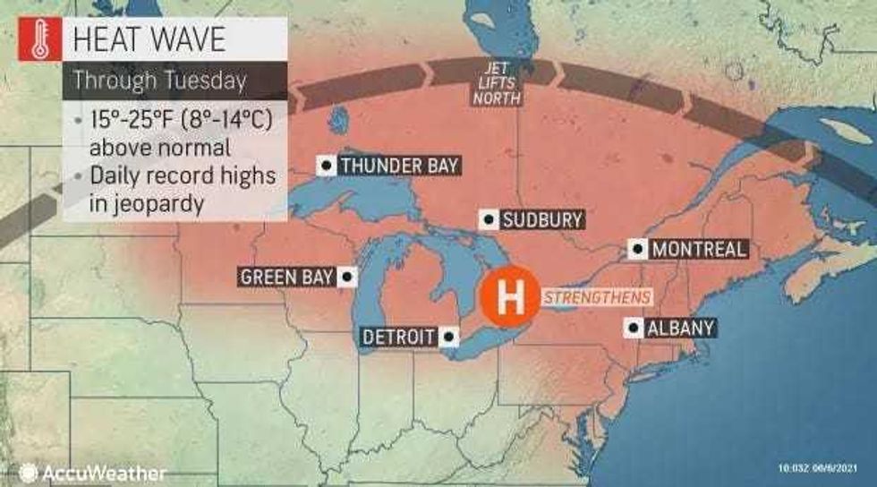
While a full heat wave is expected along parts of the east coast in places like New York and Philadelphia with three consecutive days of at least 90 degrees, the Buffalo and Western New York region will be hot enough with daytime highs in the upper 80's.
Along with the heat will come the humidity for the next few days with some thunderstorms thrown in along the way.
"Humidity levels will be higher than most people in the region have experienced thus far this year, but they will be a bit short of the levels often experienced during dog days of July and August," AccuWeather Senior Meteorologist Alex Sosnowski said.
CHECK: Complete WBEN First Alert Forecast
The National Weather Service reporting:
It will be very warm the next couple of days with increasing amounts of humidity. While dry weather can be expected through tonight...the increased heat and humidity will help support some showers and thunderstorms over the Southern Tier and Finger Lakes region Monday afternoon. Sultry conditions will lead to a greater coverage of showers and possible thunderstorms on Tuesday and Wednesday.
&& .NEAR TERM /THROUGH MONDAY/...
An amplifying ridge over the Lower Great Lakes will support fair dry weather over our forecast area through tonight. While not especially humid...it will be quite warm today with max temps reaching the lower 90s across the lake plains...mainly east of Batavia. Elsewhere temps will peak in the mid to upper 80s.
More humid air will move into the region on Monday. This will fuel some showers and thunderstorms...primarily in the vcnty of a lake breeze boundary over the Southern Tier and Finger Lakes during the afternoon. Lake shadowing should maintain fair dry weather in a corridor from lake Erie and the IAG Frontier to Rochester over to the North Country. Max temps will be similar to those from today...
but notably higher humidity levels will support apparent temps in the low to mid 90s. Given there is enough sun...a heat advisory may be needed from Rochester east towards Syracuse.
SHORT TERM /MONDAY NIGHT THROUGH TUESDAY NIGHT/...
Although diurnal convection will continue to drive the train with regards to the best precip potential, weak shortwaves passing over our area on the periphery of the upper ridge will keep at least the chance for a few showers and storms in the forecast for Monday night and Tuesday night. Will see an uptick in the potential for convection (as compared to previous days) from around midday through early evening Tuesday as a stronger upper wave passes over the area during peak heating. Modest instability combined with PWATs ranging from 1.5-1.8" will bring the likelihood for showers and storms, especially inland of lake breeze circulations. With abundant moisture available and model soundings advertising tall skinny CAPE profiles and fairly weak flow aloft, the main threat from any stronger storms will be the potential of producing localized heavy rainfall.
Otherwise, more in the way of cloud cover and precipitation will knock temperatures back a few notches, however humidity levels will remain elevated. Expect daytime highs in the low to mid 80s for the majority of the region, with some upper 70s along the lakeshores and across the higher terrain.
&&


