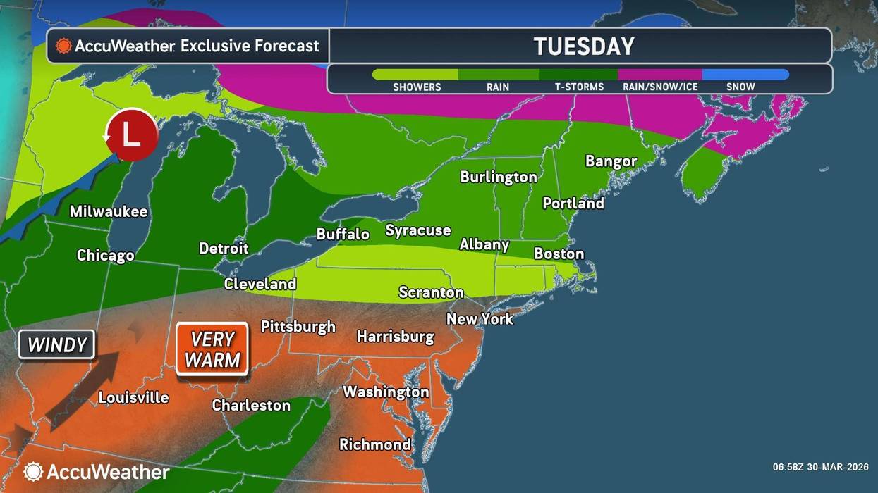
Rounds of rain are in the forecast for the Buffalo Niagara and Western New York region Tuesday, with the potential for some strong to severe storms, especially late in the day, National Weather Service forecasters say.
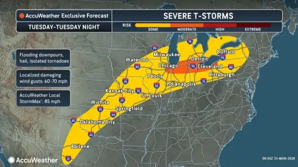
"The last round of storms are the ones that might be severe," National Weather Service meteorologist Jon Hitchcock tells WBEN of the storms crossing the area late in the day Tuesday. "Local damaging winds and very heavy rainfall."
A Severe Thunderstorm Watch is posted for ALL of WNY through 9 p.m.
Since the rain system has moved through the region beginning late Monday, the WNY region has dodged many of the heavier storms that have moved through, potentially reducing a flood risk for the area. A Flood Watch is posted for ALL of WNY through Wednesday.
Early in the day Tuesday, the heaviest rainfall will likely be confined to areas from Buffalo northward.
As for the timing for the potentially strong to severe storms?
"It looks like the worst of the storms will start mid-afternoon...lasting until mid-evening," Hitchcock predicts. If he had to pinpoint the worst times of the day, Hitchcock says the 3 p.m. and 9 p.m. hours look particularly volatile.
The threat of severe weather, including possible tornadoes, does exist for the region, Hitchcock cautions.
"The main risk is going to be localized, damaging winds, but there is a secondary, lower risk of large hail and an isolated tornado," Hitchcock says, but adds that most people won't see severe weather today and it will be very isolated if it does occur.
 AccuWeather.com
Temperatures will feel very warm, compared to what the region has felt of late, with highs in the mid to upper 60's Tuesday.
And more rain will be on the way as the week unfolds. "Looks like we get a little break through the first half of tomorrow, but then more rain late tomorrow, through Thursday, Friday, even into the weekend," Hitchcock notes. "There's several more rounds of rain...there's more rain in our future right through the weekend."

FLOOD WATCH REMAINS IN EFFECT FROM 8 AM EDT THIS MORNING THROUGH
WEDNESDAY EVENING
* WHAT...Flooding caused by excessive rainfall continues to be
possible.
* WHERE...Portions of central and western New York, including the
following counties, in central New York, Northern Cayuga. In
western New York, Allegany, Cattaraugus, Chautauqua, Genesee,
Livingston, Monroe, Niagara, Northern Erie, Ontario, Orleans,
Southern Erie, Wayne and Wyoming.
* WHEN...From 8 AM EDT this morning through Wednesday evening.
* IMPACTS...Excessive runoff may result in flooding of rivers,
creeks, streams, and other low-lying and flood-prone locations.
* ADDITIONAL DETAILS...
- Multiple rounds of showers and embedded thunderstorms are
expected early this morning through tonight which may result
in 1.0" to 1.5", with localized amounts of 2.0" if
thunderstorms repeat over the same area. Excess runoff from
this rainfall may cause area waterways to reach or exceed
bankfull stage. General flooding away from area waterways
will also be possible during this timeframe, especially in
typical low-lying and poor drainage areas.
PRECAUTIONARY/PREPAREDNESS ACTIONS...
You should monitor later forecasts and be alert for possible Flood
Warnings. Those living in areas prone to flooding should be prepared
to take action should flooding develop.