
Buffalo, N.Y. (WBEN) - This Wednesday before Thanksgiving is traditionally the busiest travel day of the season and strong winds will be the order of the day as thousands of Western New Yorkers drive and fly to arrive at their destination for Thanksgiving Thursday.
TRACK: Daily WBEN 7 First Alert Forecast
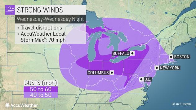
Strong winds are forecast to cross the region during the day Wednesday with winds of 25 to 35 mph and gusts to as high as 60 mph at times according to the National Weather Service.
As the storm system moves off the east coast by Thanksgiving Day, chilly air will be funneled into the Northeast, allowing rain to switch over to snow showers across interior areas.
The storm system could also could mean disappointment for fans of the larger-than-life balloons that are flown at Macy’s Thanksgiving Day Parade in New York. Organizers of the parade were preparing for the possibility that they’ll have to ground the iconic balloon characters with 40-50 mph (64-81 kph) gusts in the forecast. Rules put in place after several people were injured by a balloon years ago require lower altitudes or full removal if sustained winds exceeded 23 mph (37 kph) and gusts exceeded 34 mph (54 kph). The decision will be made on the day of the parade.
Chilly, blustery weather is likely to persist across the Northeast for Black Friday shoppers.
HIGH WIND WARNING IN EFFECT FROM 10 AM WEDNESDAY TO 1 AM EST THURSDAY
* WHAT...Southwest winds 25 to 35 mph with gusts up to 60 mph expected.
* WHERE...Niagara, Orleans, Northern Erie, Genesee, Wyoming, and Cattaraugus counties.
* WHEN...From 10 AM Wednesday to 1 AM EST Thursday.
* IMPACTS...Damaging winds will blow down trees and power lines, and lead to scattered power outages. Unsecured holiday decorations could also be damaged. Travel could be difficult, especially for high profile vehicles.
PRECAUTIONARY/PREPAREDNESS ACTIONS... People should avoid being outside in forested areas and around trees and branches. If possible, remain in the lower levels of your home during the windstorm, and avoid windows. Use caution if you must drive. Secure or shelter loose objects and holiday decorations in a safe location prior to the onset of the strong winds.
HIGH WIND WARNING REMAINS IN EFFECT FROM 7 AM THIS MORNING TO 1 AM EST THURSDAY
* WHAT...Southwest winds 25 to 35 mph with gusts up to 60 mph expected.
* WHERE...Chautauqua and Southern Erie counties.
* WHEN...From 7 AM today to 1 AM EST Thursday.
* IMPACTS...Damaging winds will blow down some trees and power lines, and lead to scattered power outages. Unsecured holiday decorations could also be damaged. Travel could be difficult, especially for high profile vehicles.
PRECAUTIONARY/PREPAREDNESS ACTIONS... People should avoid being outside in forested areas and around trees and branches. If possible, remain in the lower levels of your home during the windstorm, and avoid windows. Use caution if you must drive.
LAKESHORE FLOOD WARNING IN EFFECT FROM 10 AM WEDNESDAY TO 1 AM EST THURSDAY
The National Weather Service in Buffalo has issued a Lakeshore Flood Warning, which is in effect from 10 AM Wednesday to 1 AM EST Thursday. The Lakeshore Flood Watch is no longer in effect.
* LOCATIONS...Erie and Chautauqua counties.
* LAKE SHORE FLOODING...A rapid rise in water level combined with already high lake levels and significant wave action could result in lakeshore flooding.
* TIMING...From 10 AM Wednesday to 1 AM EST Thursday.
* IMPACTS...Lakeshore flooding, especially in bays, inlets, and other low lying areas along the lakeshore. Significant shoreline erosion is also possible. Route 5 in the Town of Hamburg may be impacted.
PRECAUTIONARY/PREPAREDNESS ACTIONS... For your safety, stay off breakwaters, piers, rock outcroppings, and beaches! Waves are often larger than they appear and can easily wash you away. Expect significant beach erosion and debris, local road closures, and extremely dangerous boating conditions.