The first real snowstorm of the winter season is here, and snow will get heavier (and roads will get dicier) as the afternoon goes on. A few weather nuggets:
1). Heaviest snow is forecast to come late this afternoon into the evening hours, when snow may fall at the rate of 1"/hour (possibly 2-3"/hour far south metro).
2). The farther south you drive, away from MSP, the worse the travel conditions will be.
Predicting the weather is a little easier than predicting how bad I-35 will be later today, but personally, I will do everything in my power NOT to be driving later today.
3). This is not a blizzard, winds stay under 15 mph - so I don't expect blowing and drifting.
That said, near white-out conditions are possible, especially in the axis of heaviest snow setting up just south of MSP.
4). How many inches in my yard, Paul? I demand answers! Well, it depends where you live.
North metro will see 2-5" with 6-8" southern suburbs, and closer to 8-12" for far southern suburbs (especially south of the Minnesota River). Plowable, bordering on crippling as you get south of Lakeville.
5). Axis of heaviest snow setting up New Ulm and Mankato to Faribault, Owatonna and Red Wing, where some 12-15" totals can't be ruled out by Saturday morning.
There may even be "thundersnow" south of the metro, implying snow falling at a rate of 2-4"/hour. Good times.
6). Assuming MnDOT crews are out tonight roads should be in fairly decent shape by Saturday afternoon. I'd be more concerned if we had high winds with this system (we don't) so you should be able to get around OK by tomorrow midday and afternoon.
In theory. On paper. Your results may vary.
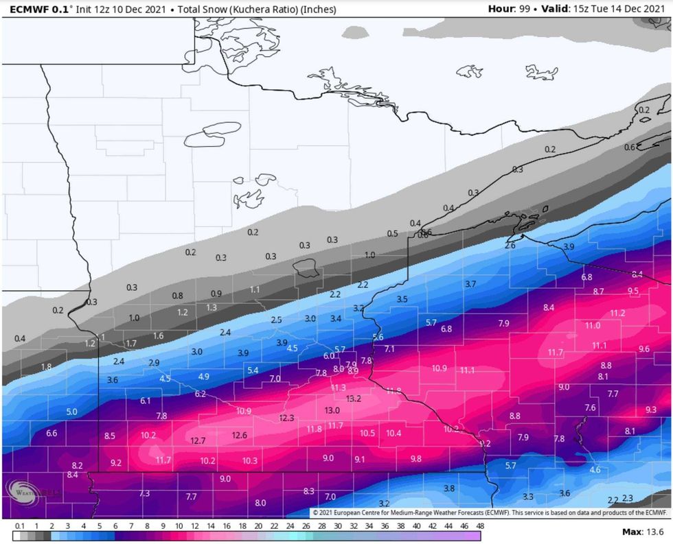 European Model Snow Map(map credit: weatherbell.com)
Latest European Model (ECMWF) Snowfall Predictions. Immediate south metro picks up close to 8" (give or take a foot) with a foot possible far southern suburbs. Meanwhile St. Cloud and far northern suburbs are lucky to pick up an inch or two. It's no fun being on the northern edge of the heavy snow band.
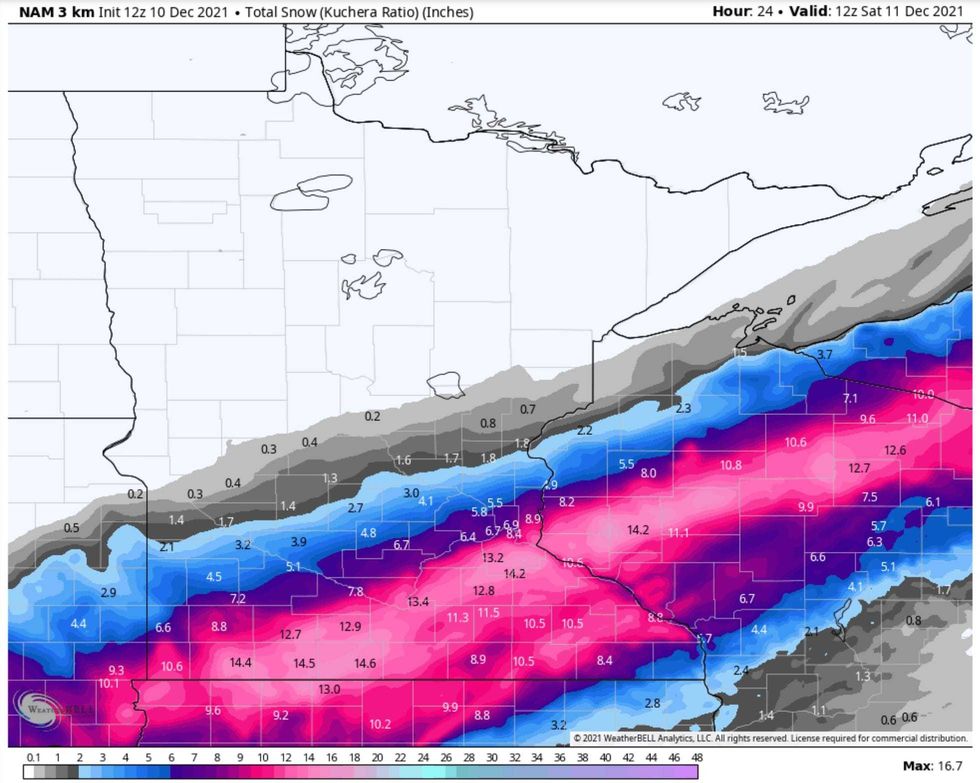 NOAA Snow Map(map credit: Twin Cities National Weather Service)
High-Resolution NAM Model Solution. NAM is tracking pretty well with ECMWF, with heaviest snowfall amounts southern and eastern suburbs.
Red = Good, right? Asking for a friend (who loves snow).
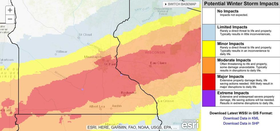 Winter Storm Severity Index(map credit: NOAA)
Winter Storm Severity Index. NOAA's WSSI scale predicts moderate to major impacts from today's storm, with conditions worsening as you head south and east toward Eau Claire. The smudge of red over the Twin Cities metro is a reflection of population density and more cars on the highways (I think). Again, not a blizzard, but the snow will really be coming down between 2 pm and 10 pm.
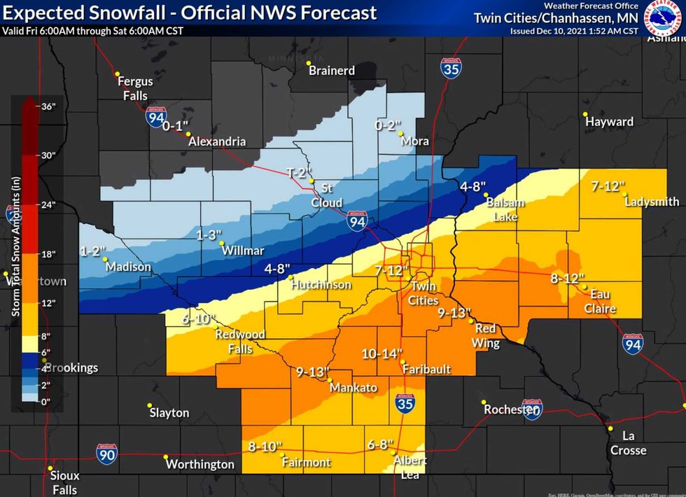 Official National Weather Service Snow Prediction(map credit: Twin Cities National Weather Service)
Official National Weather Service Prediction. The Twin Cities office of the NWS is more aggressive with snowfall totals for the immediate metro, which could very well happen. I'm being somewhat conservative with 4-8", but increasingly confident that southern suburbs, including MSP International (where official snow amounts are measured) will pick up 8" with a few 10" amounts closer to the Minnesota River.
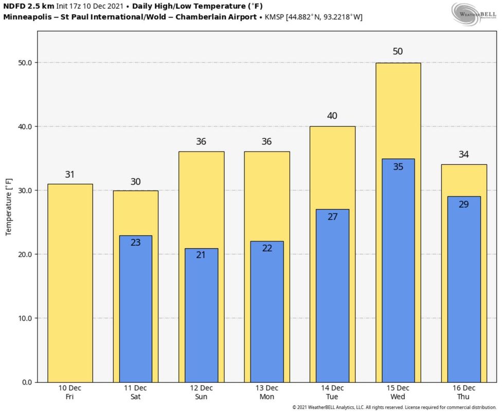 Extended forecast(graphic credit: Weatherbell.com)
Note to Snow Lovers: Play in the White Stuff This Weekend. Models predict a thaw next week with a few days at or above 40 degrees - 50F still not out of the question next Wednesday. Prediction: whatever falls will become slushy and mushy next week, but I suspect we will hang on to enough snow for a white(ish) Christmas this year.
We'll keep you posted with coverage on our show from 3-6 pm on WCCO Radio. I hope you can join us (and weigh in with observations and questions). Good luck out there.
PS. If you don't like snow or winter consider that the Winter Solstice arrives in 11 days. In 15 days we pick up 1 minute of additional daylight in the Twin Cities. Spring is right around the corner! Uh huh.