As we head into a holiday weekend, there’s good news and bad news in Minnesota.
WCCO’s Chief Meteorologist Paul Douglas says we’re starting with some more smoky air, but it is looking very summer-like for the traditional kickoff to Minnesota’s summer, Memorial Day Weekend.
Air Quality Alert
The Minnesota Pollution Control Agency (MPCA) has issued an air quality alert for southern Minnesota, from 12:00 p.m. through 8:00 p.m. Tuesday. The affected area includes the Twin Cities metropolitan area, St. Cloud, Rochester, Mankato, Marshall, and the tribal nations of Mille Lacs, Upper Sioux, and Prairie Island.
Ground-level ozone is expected to be high during the afternoon hours on Tuesday, and air quality is expected to reach the Orange (unhealthy for sensitive groups) category across southern Minnesota.
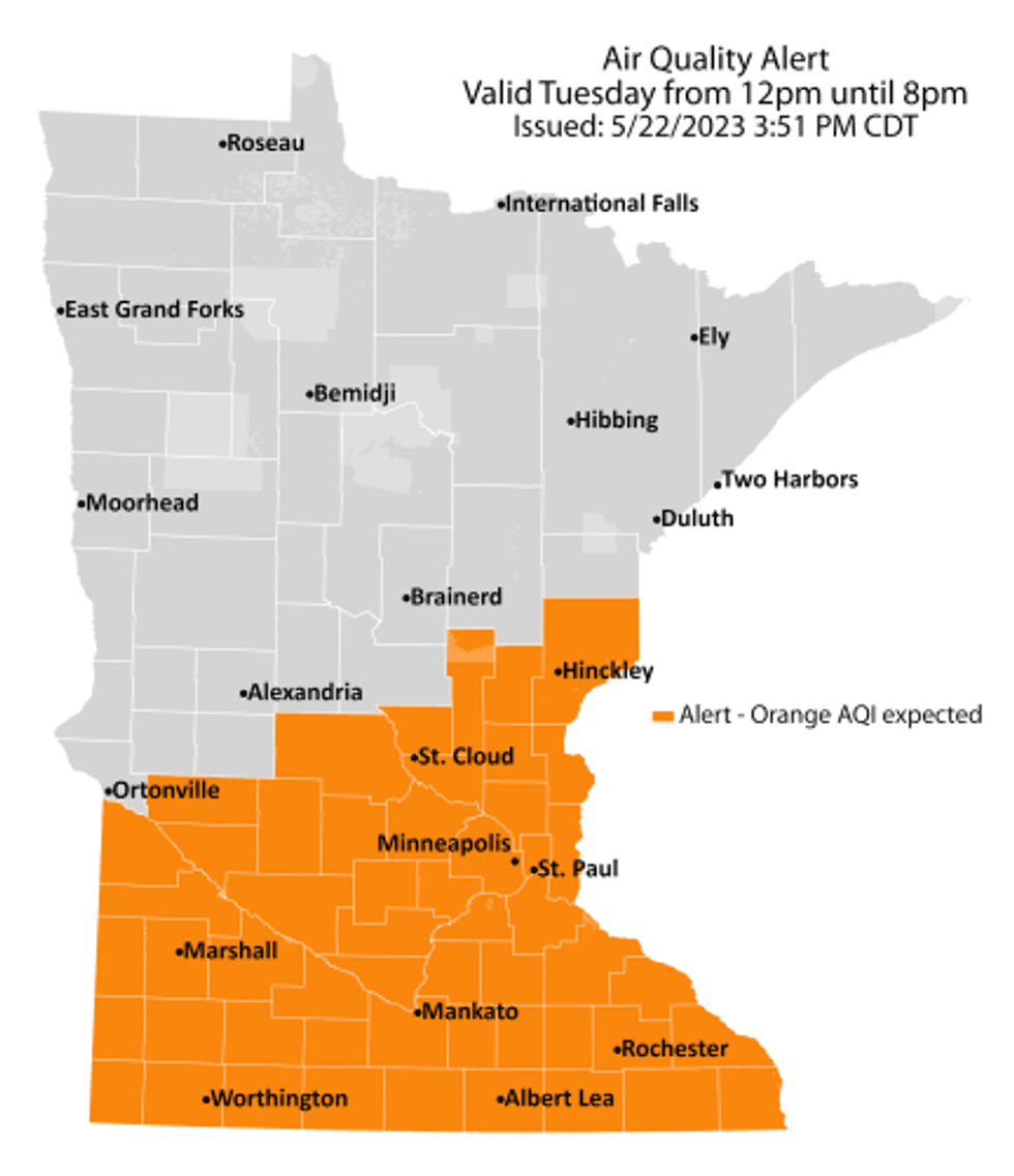 Air quality alert valid Tuesday, May 23, from noon until 8 p.m.(Minnesota Pollution Control Agency)
Southerly winds are transporting pollutants into the state from Canadian wildfires, the same situation
Douglas says fortunately it won’t last long.
“A lot of people complaining about sore throats and coughing and we’ll take that one day at a time,” says Douglas. “It’ll be smoky today. I think less smoke tomorrow and Thursday.”
That doesn’t mean the air will be totally clean. There may be some hazy skies all weekend long even if it doesn’t quite reach the levels where an alert is issued.
Ozone will be highest during the afternoon and early evening hours when sunshine is most abundant, and temperatures are highest. The Pollution Control Agency is warning people to take it easy on outdoor activities as the unhealthy air can lead to issues. See more here.
Warm and Dry
“The good news is, for outdoor plans, for holiday plans, weather systems are in a holding pattern,” Douglas explains. “Normally the weather moves from west to east at about 20 miles an hour, sometimes faster, sometimes slower. That's a pretty good average. Every now and then, things stop. Things go into a blocking pattern, what meteorologists call a holding pattern, an omega block. And we're going to have one of those this weekend.”
That means very stable weather for this time of year. More like late summer.
“We will be under a bubble of high pressure meaning sunshine, dry weather,” Douglas told Vineeta Sawkar on the WCCO Morning News. “In fact, I don't see any significant rain looking out 10, 12 days for most of the area.”
We are definitely in a dry spell says Douglas. Bad for your plants. Good for outdoor plans.
Of note, we are still well out of drought conditions in most of Minnesota. Some lingering dry conditions in the far western part of the state. But this dry pattern is something to watch if it continues.
Forecast
Tuesday will be warm, smoky and hazy with highs in the mid-eighties.
Then a quick change, but only for a day.
“It will feel like summer,” says Douglas. “And then this backdoor cool front coming in late tonight. It might not get out of the upper-sixties tomorrow. Some free air conditioning with a stiff east wind.”
That short live cool off then turns into a slow warm up as we head towards the holiday.
“I think we'll be upper-seventies to near 80 on Saturday, low-eighties on Sunday and Memorial Day,” Douglas predicts. “We could be in the upper, upper-eighties almost every day next week. If you have a hankering for summer, including a little more humidity, I think you're going to be very happy with next week's weather.”
Tuesday: Warm with smoky sunshine and a high of 83.
Wednesday: Cloudier with a cooler breeze. Winds: E 10-20. High 68, low 59.
Thursday: Partly sunny and warming a bit. High 73, low 53.
Friday: Warm sun. High 77, low 52.
Saturday: Hazy sunshine. High: 79, low 57.
Sunday: Sunny and beautiful for late May. High: 81, low 58.
Memorial Day: Smoky-blue sky and very summery. High: 83, low 60.
For your Cabin-Cast, here are a few weekend spots as well:
Hayward, WI: Sunny with upper 70s all weekend, very small chance of a show on Monday.
Detroit Lakes: Mostly sunny, a bit breezier than the metro with highs in the upper 70s to near 80. There is a slight chance of some weekend rain in the NW part of Minnesota.
Brainerd Lakes: Warm with temps close to 80. Windy Friday, then nicer with a very small chance of a weekend shower.
Bemidji: Extremely warm for May, with temps in the low 80s. Very small chance of a shower each day.
North Shore: Minnesota’s air conditioner. Temps closer to 70 near Duluth, in the low 60s in the Grand Marias area, but sunny and bright skies over Lake Superior all weekend. Upper 70s inland near the BWCA.