


It's been a warm stretch for Minnesota, with over a half-year straight of above normal temperatures, and that trend looks like it will continue.
WCCO Chief Meteorologist Paul Douglas says winter is still being pushed back thanks to El Niño. If you're a snow lover, you're going to need to wait.
"I do believe we will be snow-free through the end of next week," says Douglas. "There are some hints, some of the long range guidance that closer to Thanksgiving the bubble may burst, and there's a chance of some snowier, colder weather."
But in the meantime, Douglas explains that we are in the middle of a long stretch of warm temps in Minnesota. He expects that to continue through November. The National Weather Service is also predicting above normal temperatures for the Upper Midwest looking out two weeks.
"I have a hunch this will be the seventh consecutive warmer than average month for Minnesota, just the way the pattern is shaking up," Douglas explains. "We have the biggest El Niño since 2015. In fact, all the world's oceans are unusually warm and that's like having a big hot water bottle right next to you. Chances are that will nudge the pattern in a way that keeps us a little bit milder and drier all winter."
About That El Niño
The National Weather Service's Climate Prediction Center says There is a 30% chance of a "historically strong" event that rivals 2015-16 and 1997-98 El Niño's. Those stronger El Niño events increase the likelihood of El Niño-related climate anomalies. For Minnesota and much of the Upper Midwest, that means warmer and drier winters overall.
"It may be one of the first tell-tale signs of El Niño: a pattern that favors big (cold) storms over the western USA and Gulf Coast, with relative warmth over the Upper Midwest," Douglas says.
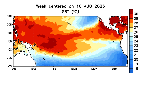 October temperatures in the Pacific Ocean show equatorial waters significantly warmer than normal from August-November, which ushers in a winter of El Niño.(Image courtesy of the National Weather Service / NOAA)
As for those warm ocean temperatures, they're actually and literally "off the chart". Compared to the strong El Niño's in past years, the equatorial waters are similar, but in 2023 that water is surrounded by much warmer than average water. After setting several record sea temperatures over the summer, the ocean continues to be superheated heading into winter.
As always with weather compared to the world's climate, results may vary in your backyard explains Douglas.
"That's not to say we won't get a few big snowstorms," he says. "We probably will. But nothing in sight through the end of next week."
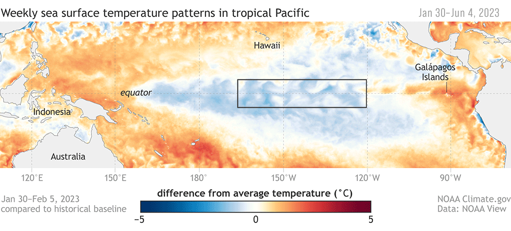 The June animation of warming Pacific Ocean waters, which was the beginning of El Niño.(Image courtesy of the National Weather Service / NOAA)
Forecast
"A few light sprinkles today, some heavier, steadier rain tonight. Doesn't look like much. Maybe a tenth of an inch of rain. We dry out tomorrow and cool off. The end of the week we're looking at highs right around 40, maybe low-40s. Few degrees cooler than average which is 46."
Next week, the week before Thanksgiving, looks like it will be unseasonably warm says Douglas.
"Next week still looks fairly mild," he says. "More October than mid-November. We could see four, maybe five days in the 50s. We could come close to 60 by the middle of next week before things cool off. The honeymoon continues. I'm OK with that. We'll make up for it."
Tuesday- PM showers. High 48.
Wednesday- Damp start. High 52, low 43.
Thursday- Mostly cloudy, cooler. High 44, low 35.
Friday- Cloudy with sprinkles. High 43, low 32.
Saturday- Peeks of sun but chilly. High 40, low 31. mph.
Sunday- Partly sunny, waking up cold. High 46, low 28.


