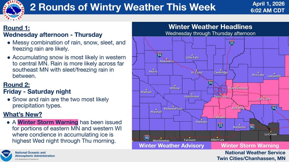
It's no joke on this April fool's day. The National Weather Service has issued a Winter Weather Advisory for a large swath of Minnesota and Western Wisconsin, with a Winter Storm Warning from the southeast metro and areas further to the east.
Those begin Wednesday and run into Thursday night.
National Weather Service Meteorologist Joe Calderone says commuters should prepare for a hazardous Wednesday evening and Thursday morning as a spring storm brings a mix of freezing rain and heavy sleet to the region.
"The greatest snowfall amount is going to be in western and central Minnesota," Calderone explains. "So that's where you're gonna have 3 to 6 (inches). You go around here towards the metro, closer to an inch, and potentially even less than that because that's where the ice accumulation becomes higher."
Snow - even winter storm warnings - in April are not unusual in Minnesota according to WCCO-TV Chief Meteorologist Chris Shaffer. But, April storms tend to be a little different than other parts of winter.
"You hear winter weather advisory and winter storm warning, you think we're gonna get pummeled with snow and that has happened before," he says. "We do average 3.5 inches of snow in the month of April. It did snow last April 1st. We got 2.1 inches of snow, and, I saw 13 years ago, the 31st of March into April 1st, 2023, 8.5 inches of snow. So we got slugged. So you're thinking, oh no, here it comes again."
But, this one is sloppy, and perhaps icy, not necessarily with accumulating snow.
"I'd rather have just snow than the potpourri of precipitation we're going to have coming through tomorrow morning," Shaffer says. "In fact, if you have some scooting around to do this evening, any errands, you should be fine as well. Now, the rain is going to arrive this evening, but it should say rain in the evening hours. So I'm not worried about that. The timing of this is good. Most of this is going to happen overnight while we sleep. That rain will change over to some wet snow."
Calderone says his first wave is expected to ice over roads and cause significant travel delays before tapering off Thursday evening. But he says this initial wave threatens to hamper the Thursday morning commute significantly.
"It'll start out as mainly a rain snow mix," he says. "The bulk of the rain will be basically near and south of the metro, whereas the snow part of this will be in western Minnesota from around Wilmar or so. And then up through St. Cloud and going up towards Hinkley."
If you do decide to venture out on the roads, monitor local conditions closely as temperatures will be on the edge of creating extremely icy conditions.
But wait, there's more. A second round of heavier snow is currently projected to follow on Friday into Saturday. This actually includes some good news for the Twins, who host Tampa for the home opener at 3:00 p.m. Friday.
"Friday, there's a bit of a lull in the action. Enjoy that," Shaffer says. "41, so still cool with more rain coming in. This looks to be late afternoon, could be light. I can't tell what that means for the Twins game, I think there could be some light rain showers. What they do with it, whether they postpone, delay, cancel, but it's going to be a better chance of rain heading into the night. That too will change over to snow heading into Saturday. I don't think we see a lot of accumulation with that either. And then everything settles down on Easter Sunday."
That Easter Sunday forecast looks like mostly sunny skies, but still chilly with a high of 43.
Winter returns Thursday night with a mix of snow, freezing rain, and sleet through Thursday.
(National Weather Service Twin Cities)
WINTER WEATHER ADVISORY NOW IN EFFECT FROM MIDNIGHT TO NOON THURSDAY
* WHAT...Mixed precipitation expected. Total snow accumulations up to one inch, sleet accumulations around one half of an inch, and ice accumulations up to two tenths of an inch.
* WHERE...Portions of central, east central, south central, and southwest Minnesota.
* WHEN...From midnight tonight to noon CDT Thursday.
* IMPACTS...Plan on slippery road conditions. The hazardous conditions will impact the Thursday morning commute.
WINTER STORM WARNING IN EFFECT FROM MIDNIGHT TO NOON THURSDAY
* WHAT...Heavy mixed precipitation expected. Total snow accumulations up to one inch, sleet accumulations around three quarters of an inch, and ice accumulations around one quarter of an inch. Winds gusting as high as 30 mph.
* WHERE...Dakota, Scott, Washington, Le Sueur, Rice, and Goodhue Counties.
* WHEN...From midnight tonight to noon Thursday.
* IMPACTS...Roads, and especially bridges and overpasses, will likely become slick and hazardous. Plan on slippery road conditions. The hazardous conditions will impact the Wednesday evening and Thursday morning commutes.
CHRIS SHAFFER FORECAST
WEDNESDAY: Mostly cloudy and breezy. High: 47. E 10-15 mph.
WEDNESDAY NIGHT: Rain this evening to snow late (maybe an inch or so). Low: 30. E wind 10-15 mph.
THURSDAY: Sleet to freezing rain to rain. High: 36. NE wind 10-15 mph.
Winter Weather Advisory and Winter Storm Warning midnight Thursday until noon Thursday for travel concerns.
Average high and low….50/32