MIAMI (AP) — A weather system that is forecast to become Tropical Storm Imelda later in the day before approaching the coast of South Carolina as a hurricane early next week was causing disruption in the Bahamas and nearby islands on Sunday.
Meanwhile Hurricane Humberto weakened very slightly but remained a strong Category 4 storm in the Atlantic, threatening Bermuda.
South Carolina Gov. Henry McMaster urged people to monitor the weather closely and stay alert. And in North Carolina, Gov. Josh Stein declared a state of emergency in advance of the system, currently called Tropical Depression Nine.
Forecasters said the system was on track to become a tropical storm later Sunday and a hurricane by late Monday or Tuesday. It would be named Imelda.
At about 11 a.m. ET, the storm was located about 100 miles (161 kilometers) northwest of the eastern tip of Cuba and about 23 miles (43 kilometers) west-southwest of the Central Bahamas. It was headed north-northwest at 7 mph (11 kph). Its maximum sustained winds were 35 mph (55 kph).
“What we learn every time is we never know where they are going to go,” McMaster said during a news conference to discuss the storm. “This storm is deadly serious. Not just serious. Deadly serious."
The storm could bring high winds and heavy rain, which could produce flooding, he said. The state was prepositioning search and rescue crews over the weekend.
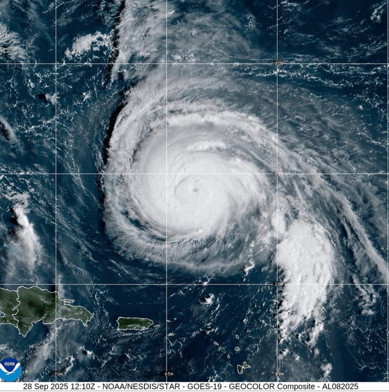
Hurricane Humberto weakens slightly but still major storm
Humberto weakened slightly on Sunday but still had maximum powerful sustained winds of 150 mph (240 kph), according to the National Hurricane Center in Miami, making it a Category 4 hurricane. It was located about 535 miles (861 kilometers) south of Bermuda and was moving west-northwest at 13 mph (20 kph).
A tropical storm watch could be required in Bermuda later in the day, forecasters said, and swells could reach the U.S. East Coast on Monday.
Alison Dagostino moved to Myrtle Beach, South Carolina, six years ago with her four children and husband. She experienced her first hurricane within days of moving into the area.
She said that other than basic storm preparation — like buying batteries and storm-proofing windows — people in the area were living life as normal on Sunday, ahead of the impending storm.
“People are still out and about. People are still walking on the beach,” Dagostino said, adding that school and sports games haven't been canceled.
Bracing for Tropical Depression Nine
Tropical Depression Nine was threatening parts of Cuba and the Bahamas with heavy rainfall and flash flooding, with portions of the latter under a tropical storm warning. Eastern Florida and coastal Georgia are also likely to experience tropical storm conditions.
On Sunday morning Tropical Depression Nine was about 300 miles (483 kilometers) northwest of eastern Cuba and 95 miles (153 kilometers) west of the central Bahamas, crawling northward at 7 mph (11 kph).
The Bahamas’ Department of Meteorology said moderate to heavy rains would continue over the northwest and central islands, which include Nassau, Andros Island, San Salvador and Long Island, as the system moved slowly on Sunday. The National Hurricane Center in Miami predicted rainfall in that region to reach between 6 inches (15 centimeters) and 12 inches (30 centimeters), with some isolated areas seeing up to 10 inches (25 centimeters).
“Residents in low-lying areas should take actions to mitigate property damages due to flooding,” the Bahamas’ Department of Meteorology said in a statement.
Sunday’s storm surge was expected to raise water levels up to 3 feet (91 centimeters) above normal tide along the coast of Abaco, the north and east coasts of Grand Bahama, and all nearby cays.
The National Weather Service in Puerto Rico warned inexperienced mariners and those operating smaller boats against navigating the hazardous waters on Sunday, with swells from Humberto forecast to reach between 7 feet (2 meters) and 8 feet (2.4 meters) in Atlantic waters.
The tropical disturbance brought heavy rains to the Dominican Republic on Friday, leading authorities to evacuate hundreds of people and declare a red alert in five provinces.
In the Pacific
Tropical Storm Narda is rapidly weakening and is expected to become a post-tropical storm by Sunday evening or Monday.
Narda, formerly a hurricane, is affecting coastal Mexico and Baja California Sur, forecasters said, and life-threatening surf and rip current conditions are possible in Southern California. No coastal watches or warnings were in effect midday Sunday.
___
Associated Press writers Safiyah Riddle in Montgomery, Alabama and Regina Garcia Cano in Caracas, Venezuela, contributed.