METRO DETROIT (WWJ) - It's a hot and humid start to the midweek, but strong storms -- carrying the threat of large hail and strong winds -- are possible into the evening hours on Wednesday.
The National Weather Service has placed most of all Lower Michigan at a 'Marginal Risk' of severe weather for Sept. 6 with the biggest chance for strong storms forecasted to blow in after 3 p.m.
Experts say showers and thunderstorms are "likely" across the region starting later this morning. Scattered thunderstorms are expected to develop this afternoon along or ahead of the cold front.
Yet another round of storms, carrying the threat of an isolated cell, are possible from 6 p.m. to midnight.
"Damaging wind to 60 mph is the primary hazard," the NWS said.
AccuWeather predicted winds could reach 70 mph with some localized gusts at 75 mph. The storms could also produce large hail up to 1" in diameter and localized flooding.
"These severe weather impacts may be more localized in nature, compared to heavy downpours," AccuWeather Senior Meteorologist Matt Benz added.
Storm motion will be southwest to northeast at 25 to 30 mph.
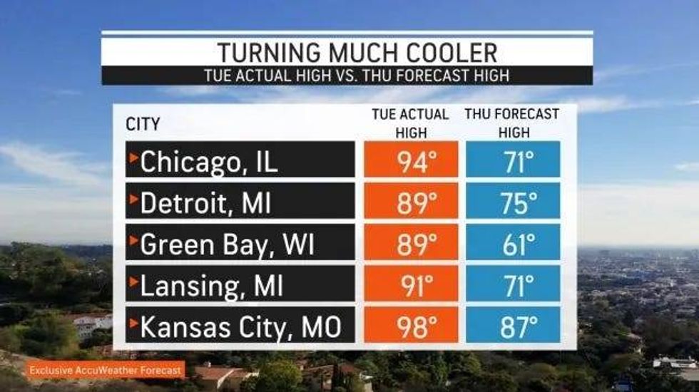
The approaching front, which will spark rounds of thunderstorms stretching from central Michigan to western Tennessee, may finally bring an end to the wave of exceptional heat across the Midwest and Northeast.
 AccuWeather
"The drop in temperature will be as much as 20-30 degrees below the peak heat from earlier in the week," AccuWeather stated.
AccuWeather forecasters say while no severe weather risks will continue to plague Michigan, the wet weather may stick around. According to AccuWeather Meteorologist Dean DeVore, there is a small chance for thunderstorms on Thursday as the upper level disturbance slowly moves out of the area.
DeVore said it'll drop into the upper sixties later on Wednesday, and while not as hot, it'll still be humid on Thursday with temperatures reaching the mid-70s. it then gets much cooler, closer to 70, with more clouds than anything Friday and Saturday.