
A brief cooldown today, a rapid warm up tomorrow and Saturday, and then the big weather change arrives here Sunday morning bringing with the threat for strong thunderstorms and then much cooler aira as well. And then it stays cool for this time of the year through Wednesday of next week.
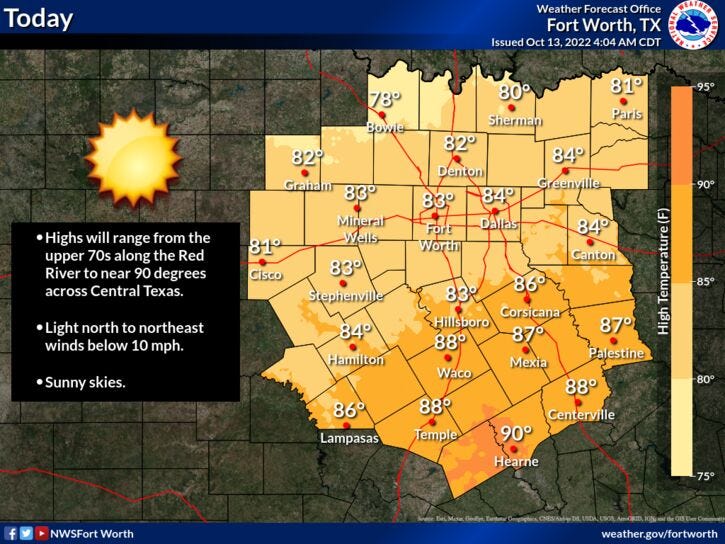
We're waking up to temperatures between 50° and 60° at this hour. Sunny and pleasant conditions will prevail today. We'll be a good 12° cooler than yesterday's high of 94°, and a lot cooler than Waco's 100° temperature they hit yesterday. That was the latest triple digit temperature ever in the city of Waco.
Tonight, it won't be as cool with readings in the upper 50s to low 60s. Sunny and warmer conditions will prevail tomorrow with highs back in the upper 80s. Sunshine and low 90s for Saturday.
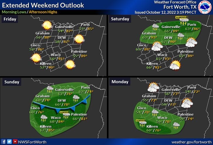
By Sunday morning, a lot of you may be awakened to the rumbles of thunder and some strong storms. A very strong cold front will be sagging through the area during the day on Sunday bringing some welcome rain and much cooler temperatures to north Texas! This line of showers and storms looks to plow through the area sometime before noon on Sunday and continue to slowly drift to the south. It's way too early to tell if these will be severe, but something I will definitely monitor for you. Temperatures will start off in the low 70s Sunday morning. We may get up into the mid 70s before the rain hits and then temperatures will rapidly fall through the 60s during the day. By afternoon, most of the rain will sag south of the area. There is a chance for more rain late Sunday night into early Monday, depending on the track of the upper level low. Right now I'm thinking the heaviest rain will be west and south of DFW.
On Monday, we'll see the clouds slowly head out of the area but temperatures will remain cool. Afternoon highs will only be in the mid 60s. Tuesday and Wednesday stays nice as well with plenty of sunshine. Morning lows will be in the mid-40s to low 50s, afternoon highs will be in the mid to upper 60s. A slow warm up is expected by the end of next week.
*Yest Rain: 0.00"; High: 94; Low: 69
*Today’s Averages: High: 80; Low: 58
*Record high: 97 (1910); Record low: 38 (1977)
*October rain: 0.00"; October deficit: 1.40"
*2022 Rain: 23.42”; 2022 deficit: 5.25"
*Sunrise: 7:31am; Sunset: 6:57pm
Today: Sunny and a bit cooler. Low humidity. High: Low to mid 80s. Wind: NE 5-10 mph.
Tonight: Clear, not as cool. Low: 58-64. Wind: Lt. Var.
Friday: Sunny and a bit warmer. High: Upper 80s. Wind: South 5-10 mph.
Saturday: Sunny and hot. Increasing clouds by evening. Chance of showers and storms toward midnight. Some strong. High: Low 90s.
Sunday: Cloudy, breezy and cooler. Chance of showers and storms in the morning, then again by evening. High: Low 70s, cooling into the 60s by evening.
Monday: Cloudy, windy and cool. Scattered showers and storms early. High: Low to mid 60s.
Tuesday and Wednesday: Sunny and cool. Highs: Mid to upper 60s.
Related

LISTEN on the Audacy App
Sign Up and Follow NewsRadio 1080 KRLD