
Enjoy the cooler morning. Everybody has dropped into the upper 60s to low 70s at this hour. Average low is 74°.
We'll all get to enjoy temperatures slightly below average for the next several mornings, as this dry air mass isn't going anywhere anytime soon. And believe it or not, there's not one Heat Advisory or Excessive Heat Warning anywhere across the state for the first time in a very long time.
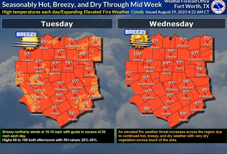
With a northeast wind continuing for the next few days, temperatures will still be slightly above average, which is 94° today, through the rest of the week. Afternoon highs will be back in the mid-90s today, upper 90s tomorrow and Thursday, pushing 100° on Friday. I doubt any Heat Advisories will be in place.
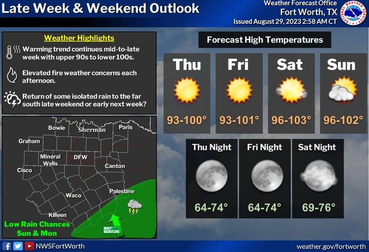
That might change this weekend as a southerly wind returns and the humidity levels go up just a little bit. There's also a very slight chance for an isolated shower or storm well to the east of DFW into the Piney Woods this weekend. Afternoon highs will approach 100°, with the heat index value approaching 105°. That's the threshold for a Heat Advisory. No changes in the forecast for Labor Day.
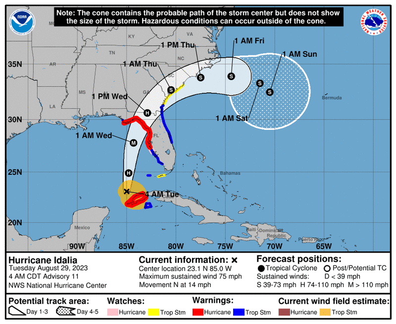
In other news, Idalya has become a hurricane overnight! Wind as of 4:00 a.m. is at 75 mph. Hurricanes form when the wind gets above 74 mph. Idaltya is forecast to become a major hurricane before making landfall sometime around noon on Wednesday along the northwestern Florida coastline. This is a low populated area, but lots of natural wildlife preserves are in this area. Makes me sad. Wind is forecast to be as high as 120 mph, but further strengthening may occur before making landfall. Preparations are already being made from Tampa Bay all the way around the bend of Florida on the Gulf side for life-threatening storm surge, heavy rain, tornadoes, and very damaging wind. Idalya will start to move more northeastward by the end of the week cruising through southern Georgia and the Carolinas before reemerging into the Western Atlantic by late this week.
*Yest Rain: 0.00"; Yest High: 95; Low: 78
*Today’s Averages: High: 94; Low: 74
*Record high: 106(2020): Record low: 60 (1993)
*August rain: Trace; Deficit: 1.91
*2023 Rain: 14.83"; Deficit: 9.45
*Sunrise: 7:01am; Sunset: 7:57pm
Today: Mostly sunny and warm. Low humidity. High: Mid 90s. Wind: NNE 10-15 mph.
Tonight: Clear and pleasant. Low: 68-72. Wind: NNE 5-10 mph.
Wednesday: Mostly sunny and warm. High: Upper 90s. Wind: NNE 10-15 mph.
Thursday and Friday: Sunny and hot. High: Near 100.
Weekend: Mostly sunny and hot. Isolated showers and storms EAST of DFW. High: Near 100.
Labor Day: Mostly sunny and continues hot. High: Near 100.
Related

LISTEN on the Audacy App
Tell your Smart Speaker to "PLAY 1080 KRLD"
Sign Up to receive our KRLD Insider Newsletter for more news
Follow us on Facebook | Twitter | Instagram | YouTube