


NEW YORK (1010 WINS/WCBS 880) – A winter storm is expected to slam the Tri-State area Saturday night and into Sunday morning, with forecasts predicting heavy snowfall in some areas, and inches of slushy snow in the city that will be dampened by rain.
Gov. Kathy Hochul spoke with WCBS 880 on Saturday afternoon about the storm, bringing information to New Yorkers about what she called a "classic Nor'easter."
Hochul talked about the importance of preparedness, and cited the state's use of the brand new, first in the nation, State Weather Risk Communication Center for providing up to date forecasts and information. The entire interview can be heard below:
Mayor Eric Adams posted a video on X on Saturday morning previewing the storm and the "light snow and wintry conditions" that will impact the five boroughs. He encouraged New Yorkers to sign up for NotifyNYC for up to date information from government agencies, and reminded the public to contact 311 with heat or hot water issues.
The Department of Sanitation issued a Snow Alert on Friday afternoon that goes into effect at 1 p.m. on Saturday, acknowledging the one to three inches of wet snow or slush expected in the city, and confirming that salt spreaders are to be used on roadways and bike lanes.
The National Weather Service New York upgraded an initial Winter Storm Watch to a Winter Storm Warning in the interior sections of southwestern Connecticut, southeastern New York and portions of northeast New Jersey from Saturday evening through Sunday afternoon.
A Winter Weather Advisory is in effect along I-95 in the lower Hudson Valley area, northeastern NJ, interior southeastern CT and southwestern CT.
The agency said in a post on X that while some coastal areas won't get as much snow that sticks, "impactful snowfall" is likely in interior areas, as reflected by the warnings.
NWS New York also provided an infographic with information on how to plan for a winter storm.
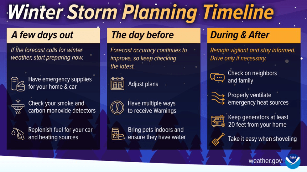 NWS New York provides information on how to prepare for a winter storm.NWS New York
New York City Emergency Management issued a weather alert for Saturday into Sunday on Friday evening,
In preparation, NYCEM also released safety tips for New Yorkers to use, including how to winterize one's home, car and go bag.
"With initial forecasts predicting a potentially significant storm hitting the tri-state area this weekend, our agencies are prepared to handle anything that's thrown our way," Adams said.
"As the tri-state area anticipates a winter weather system this weekend that could bring substantial impact, New York City's agencies are prepared and are actively coordinating with the National Weather Service and our utility partners to ensure a comprehensive response to mitigate and address any potential effects from this weather," NYCEM Commissioner Zach Iscol added.
Other city agencies posted information as the storm approaches: NYC Water reminded New Yorkers to ensure catch basins are clear of debris to avoid flooding; NYC Sanitation confirmed that it has the resources to plow any snow that may stick, despite NYC's 690 days without an inch of snow; and NWS NY provided information on how to build a winter emergency supply kit for the car.
Hochul posted a video on X Friday afternoon previewing the storm, acknowledging the end of a 692 snow drought in NYC and confirming that her state resources are deployed in preparation for the storm.
Hochul directed state agencies to mobilize emergency response assets on Thursday in preparation for the potential impacts of severe winter weather.
"We anticipate heavy, wet snowfall across various regions, potentially causing power outages and hazardous travel. I urge New Yorkers to be vigilant," Hochul said. "Prepare your households, monitor local forecasts, and plan for the next couple of days as the forecast comes into clearer view. Together, we'll weather the storm."
 AccuWeather
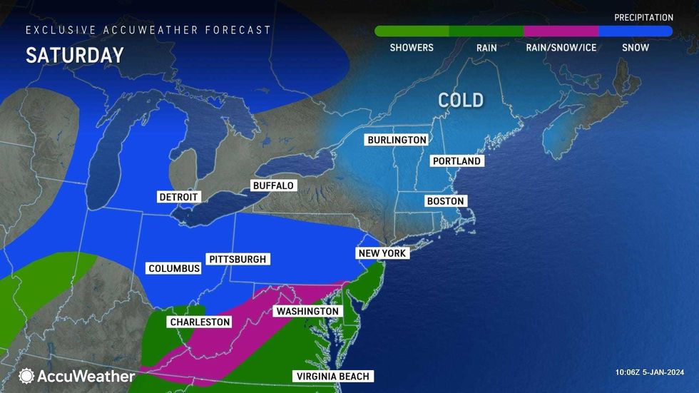
The rain and snow arrives late in the afternoon or evening on Saturday, according to AccuWeather, with a daytime high of 38.
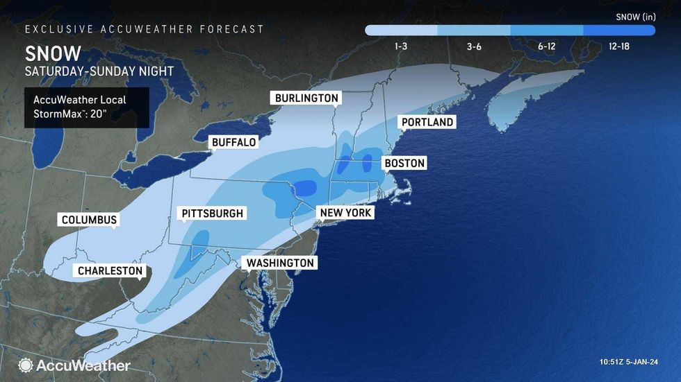
About 1 to 3 inches of slushy snow are forecast for the city and immediate northern and western suburbs.
A slushy coating to an inch in Brooklyn, Queens, Long Island and the Jersey Shore is expected, AccuWeather said.
 AccuWeather
 AccuWeather
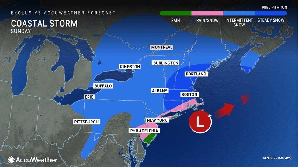
More snow, 3 to 6 inches, is expected farther north and west. In northwest New Jersey, and closer to I-84 in the Hudson Valley, snowfall could even exceed 6 inches, AccuWeather said.
With roads and sidewalks ranging from wet to slushy near and in the city to snow-covered and slippery inland, travel will be slow, AccuWeather warns.
Showers may linger into Sunday afternoon, with a deceptive high of 36. Temperatures will remain cold, however, with RealFeels in the 20s, and flurries may continue into the afternoon in some areas.
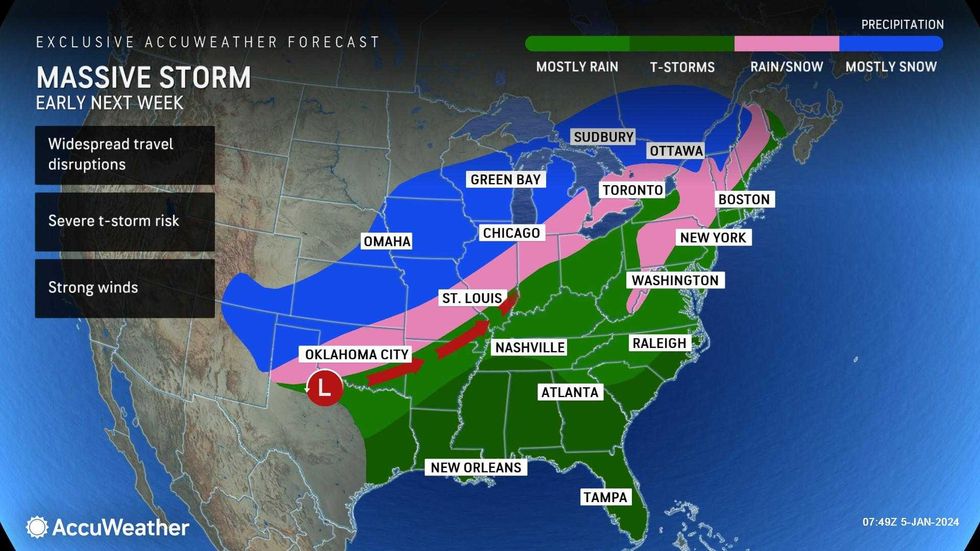
Looking ahead, AccuWeather is tracking a massive rain and wind storm that will slam the East Coast on Tuesday and Tuesday night. Heavy rain and gusty wind are expected to rage overnight after a day of clouds and rainfall.
 AccuWeather


