


Meteorologists are tracking several winter storms across the United States this week amid what has become an "unbelievable" weather pattern. One of those storms has already unleashed icy precipitation that led to deadly traffic accidents in parts of Texas on Thursday. Close to 20 million Americans throughout the country's mid-section can expect to be impacted by winter weather in the coming days.
Following right behind that is another system that meteorologists expect will track across a large portion of the middle of the nation and dip down into the south-central U.S. this weekend into early next week. That emerging storm could deliver a big blast of wintry weather to places like Dallas, which, despite its bout with icy weather on Thursday, hasn't recorded snow yet this season, and points even farther south in Texas.
"It is a stormy, stormy pattern across the country," AccuWeather Chief On-Air Meteorologist Bernie Rayno, who described it as unbelievable in his Weather Insider Podcast, said. "So far, we haven't seen much in the way of snow and ice across [the] heart of Texas, but that is going to be changing as we head into Sunday and Monday."
Temperatures are forecast to dip to record levels in the 20s, teens and even the single digits F in some cases by Saturday night in portions of Kansas, Oklahoma, Texas and Arkansas -- and that is likely to set the stage a major winter storm.
"Anytime you get an Arctic air mass into Texas, you always have to worry about snow and ice because, at some point, warmer air is going to try to return. And, when warmer air collides with that colder air, you get clouds and precipitation," Rayno said.
"The other thing you look for is if you we have any energy in the atmosphere coming toward Texas, and the answer is yes," he added.
The setup, which will trigger an extensive swath of snow and ice, will be brought on by the interaction of Arctic air in place and a flow of warmer and moist air originating from the Pacific that will sweep across Mexico and into Texas.
"A southward dip in the jet stream later this weekend will allow the moisture to flow in over top of the Arctic air," Rayno explained.
Anytime the air rises in the atmosphere, there is the potential for clouds to develop and produce precipitation. And if the air is cold enough, snow and ice can fall instead of rain. It appears it will be plenty cold enough for snow and ice to occur over much of the South Central states from Sunday to Monday. Depending on the amount of moisture available, the amount of snow and ice can be quite heavy.
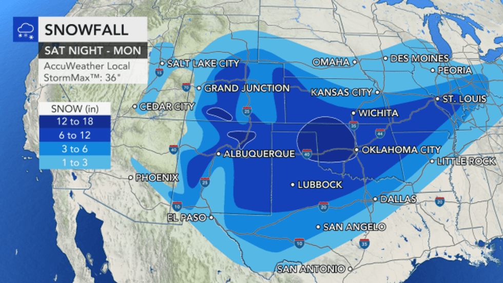
Prior to bringing snow and ice to the southern part of the Plains, the storm will spread snow southeastward through the interior West this weekend. Up to a foot or more of snow could pile up over the Wasatch Range in Utah and the Rockies in Colorado and northern New Mexico, and blizzard conditions may even develop for several hours over the passes and in the high country.
Snow is expected to continue falling at heavy rates as the storm shifts over the southern Plains Sunday into Monday. It could potentially dump several inches and up to a foot of snow across a large area, including northwestern Texas, Oklahoma, Kansas, northwestern Arkansas and southern Missouri. A small zone may be buried under up to 18 inches from the Texas Panhandle to central Oklahoma.
 AccuWeather


