


The same aircraft best known for flying directly into hurricanes are now being used to sharpen forecasts for a powerful winter storm expected to impact large portions of the country this weekend.
Crews from the National Oceanic and Atmospheric Administration and the U.S. Air Force are flying specialized Hurricane Hunter missions to collect critical data that forecasters say can significantly improve predictions of winter weather.
While Hurricane Hunters are most often associated with tropical storms, their role extends well beyond hurricane season. During major winter setups, especially those involving multiple weather systems and sharp temperature contrasts, forecasters rely on airborne observations to fill in gaps where traditional data sources are limited.
Why planes are needed for winter storms
Much of the atmosphere that influences winter storms lies over oceans, where weather balloons and ground-based observations are sparse. To close that gap, Hurricane Hunter aircraft are flying long missions over the Pacific Ocean and along the Gulf Coast, sampling the atmosphere upstream of the storm.
The data they collect feeds directly into computer forecast models used by the National Weather Service. Better data at the start of a model run often leads to more accurate forecasts days later — including improved timing, precipitation type, and temperature projections.
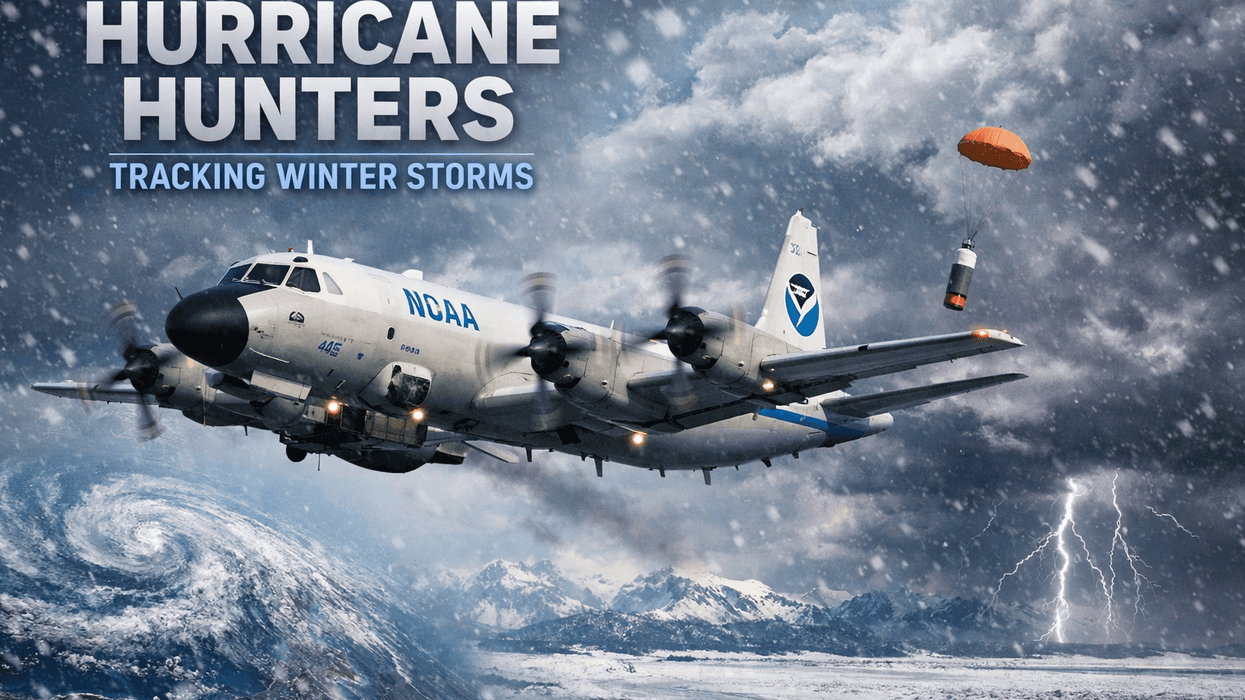
Dropsondes provide key measurements
Among the most important tools onboard are dropsondes — small instrument packages released from the aircraft as it flies at high altitude. As each dropsonde falls toward the ocean, it measures temperature, humidity, air pressure, wind speed, and wind direction, transmitting that information back in real time.
Forecasters say those measurements help define the structure of the atmosphere that will eventually move inland. For winter storms, that can mean a clearer picture of where cold air will be deep enough for snow or sleet, where ice is more likely, and how fast the system will evolve.
A rare, multi-front effort
This storm has prompted an unusually broad data-collection effort, with flights sampling both Pacific energy and Gulf moisture — two key ingredients in many major winter storms. That multi-front approach is less common but becomes crucial when a storm threatens wide geographic impacts and dangerous conditions.
Officials say these flights are especially valuable during high-impact events, when small forecast errors can mean the difference between rain and ice, or minor travel issues and widespread power outages.
What it means for the public
The data gathered by Hurricane Hunters will help meteorologists refine warnings and advisories as the storm approaches. More precise forecasts allow local governments, utilities, schools, and families to make better decisions ahead of dangerous weather.
In short, even though no hurricanes are in sight, the Hurricane Hunters are once again flying into rough conditions — this time to help communities prepare for winter's worst.
As forecasters continue to monitor the storm, officials urge residents to stay weather-aware, follow local guidance, and be prepared for rapidly changing conditions as the system moves closer.
LISTEN on the Audacy App
Tell your Smart Speaker to "PLAY 1080 KRLD"
Sign Up to receive our KRLD Insider Newsletter for more news
Follow us on Facebook | Twitter | Instagram | YouTube


