We're not done with the rain yet! About an inch of rain fell overnight across north Texas. It did prompt a couple of flood warnings west of Fort Worth. Rain will continue to head off to the east through mid-morning. Some peaks of sunshine are possible today with highs near 80°.
A weak cold front to our north will go stationary somewhere across north Texas this evening through the weekend, coupled with upper-level disturbances will produce more rain across the area. The next batch will form late this evening to our northwest and along the dryline to the west. Most areas will see another batch of rain late tonight while you're sleeping into Friday morning. The severity looks low, but rain totals look high in areas, especially just west of northwest of DFW. Morning lows will drop into the mid-60s. Rain-cooled air.
Most of Friday is looking okay, however, the dryline will spark more storms tomorrow late afternoon and evening well to the west of us. I think these will have a hard time making it into the area on Saturday morning. We'll have to wait for the next disturbance late Saturday to produce more storms to our west. This combined with a front meandering in the area will provide a railroad track for more storms late Friday night into early Saturday. Wherever the front lays will provide the railroad track for the next batch of heavier rain. Afternoon highs on Saturday will be near 80 with a break in the rain during the day.
We'll do it all over again late Saturday into the first part of Sunday as another disturbance rolls in from the west. We'll have to keep an eye on the frontal position for the railroad track of the heaviest rain. Stay tuned. Highs on Sunday will reach near 80° again.
As of now, it looks like we'll see a break in the rain Monday through Wednesday with only a few isolated showers of storms possible during peak heating Monday and Tuesday. Temperatures will warm in the mid-80s on Monday, pushing 90° on Tuesday and Wednesday. Factor in the oppressive humidity and heat index values will be in the mid to upper 90s! Ouch! Yuck!! Do not curl your hair ladies!
Please keep in mind that flooding is the number one killer with severe weather. Turn around don't drown y'all!
 NWS
NWS
7-Day Headlines:
* DFW Airport reached 81 yesterday. Overnight rain: 0.86" as of 5am
* Rain moving out, for now.
* More storms late tonight, isolated severe.
* A break in most of the rain Friday afternoon through Saturday evening.
* More storms late Saturday into Sunday.
* Drying out and warming up early next week.
_____________________________________________________
*Yest Rain: 0.00"; Yest High: 81; Low: 69
*Today's Averages: High: 79; Low: 60
*Record high: 95 (1978, 2013) Record low: 44 (2013)
__________________________________________________________
*May Rain: Trace; Deficit:
*2024 Rain: 17.27"; Surplus: 5.51"
*Sunrise: 6:39am; Sunset: 8:11pm
__________________________________________________________
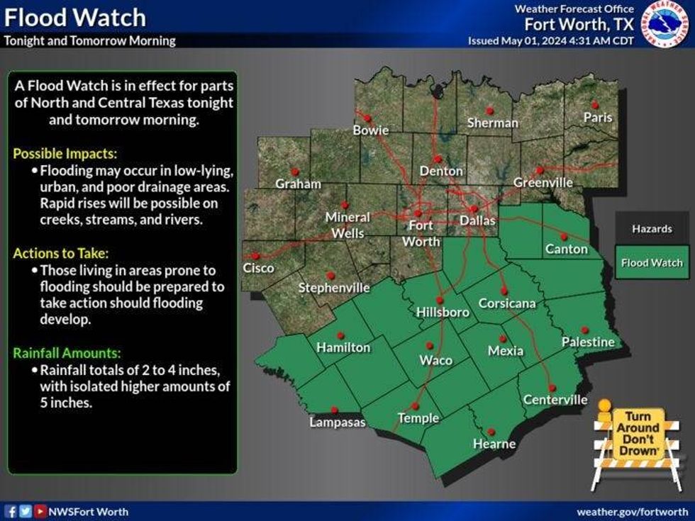
Today: **Flood Watch south and east of DFW until 1pm** Morning rain, peeks of afternoon sun. High: Near 80. Wind: South 10-20 mph.
Tonight: Scattered showers and storms. Isolated severity west and NW of DFW. Low: Mid to upper 60s. Wind: South 5-10 mph.
Tomorrow: Morning showers and storms. Some afternoon sun. High: Near 80. Wind: East 5-10 mph.
Saturday: Morning clouds, peek of afternoon sun. Scattered showers and storms late. High: Near 80.
Sunday: Mostly cloudy and seasonable. Scattered showers and storms, mainly in the morning. High: Near 80.
Monday: Partly cloudy, windy, warm and humid. Isolated showers and storms. High: Mid 80s.
Tuesday: Partly cloudy, windy, warm and humid. Isolated late day storms. High: Upper 80s.
Wednesday: Partly cloudy, warm and humid. High: Upper 80s.