Our very warm weather pattern will continue through the weekend, but cooler weather is on the way next week! Also, Hurricane Milton is back out over open water exiting Florida.
As we all know, a devastating Hurricane Milton slammed ashore Wednesday evening at around 7:30 CDT packing wind of up to 120 mph. Flooding rain, catastrophic wind damage and 126 tornado warnings (state record) were issued across the state yesterday. 47 tornado reports. All of the National Weather Service offices across Florida will be out surveying damage over the next several days. After their surveys, An EF rating will be issued for each tornado that was confirmed. The highest rain total I've seen so far was in St Petersburg where 18.54 inches of rain fell. That's a foot and a half folks!
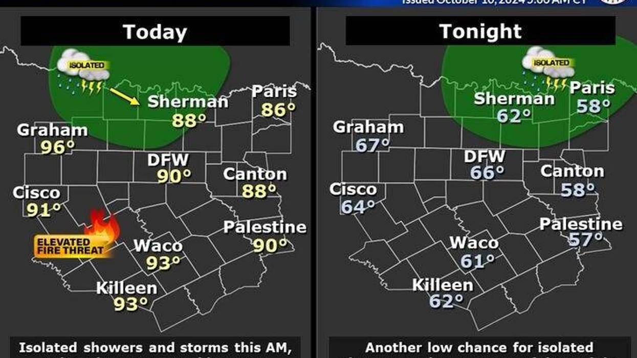
Shifting gears, our weather here across the state will be quiet over the next 7 days with cooler air arriving next Monday. We're waking up this morning to some clouds rolling in out of Oklahoma. There may even be a few sprinkles on your windshield along the north of Highway 380 as the morning moves on, but most stay dry. Afternoon highs today we reach the upper 80s.
Clear and mild tonight with morning lows 65° to 70°. Afternoon highs tomorrow will be near 90°.
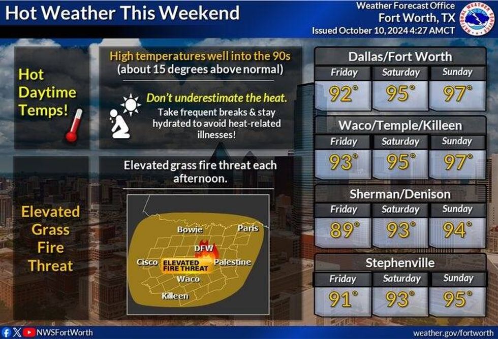
We warm up even more this weekend under a sunny sky. Saturday's highs will be in the low 90s for the Texas/OU game, Sunday, middle 90s!
 nws
nws
By Sunday night, a cold front will slide through the area. Unfortunately no rain will accompany the front. Afternoon highs on Monday will reach the mid 80s, but much cooler temperatures move in Tuesday and Wednesday, as a reinforcing shot of cool air arrives. Afternoon highs will only reach the mid 70s with morning lows in the 50s! That's more like it.
Have a great day today and try to enjoy the weather when you can, it's the only weather you've got
______________________________
7-Day Headlines:
* DFW Airport reached 86 yesterday.
* Major Hurricane Milton has moved across Florida, now back over open water.
* Landfall was at 7:30 last night near Siesta Key, FL. as a category 3 hurricane.
* Warm afternoons through the weekend.
* Cold front on Monday. No rain with it.
* MUCH cooler Tuesday and Wednesday!
_____________________________________________________
*Yest Rain: 0.00"; Yest High: 86; Low: 67
*Today's Averages: High: 81; Low: 59
*Record high: 95 (1975); Record low: 39 (1908)
__________________________________________________________
*October Rain: 0.00"; Deficit:
*2024 Rain: 33.94"; Surplus: 5.68"
*Sunrise: 7:29am; Sunset: 7:00pm
__________________________________________________________
Today: *Air Quality Alert* Morning clouds, sprinkles north, then mostly sunny and warm. Low humidity continues. High: Upper 80s. Wind: SE 10-20 mph.
Tonight: Clear and comfortable. Low: 65-70. Wind: SE 10 mph.
Tomorrow: Ample sunshine and warm. High: Near 90. Wind: South 10-20 mph.
Weekend: More of the same. Almost HOT! Late Sunday cold front, but no rain with it. Highs: Low to mid 90s.
Monday: Sunny, windy and cooler. High: Low to mid 80s.
Tuesday and Wednesday: Sunny, windy and fall-like! High: Mid 70s.
LISTEN on the Audacy App
Tell your Smart Speaker to "PLAY 1080 KRLD"
Sign Up to receive our KRLD Insider Newsletter for more news
Follow us on Facebook | Twitter | Instagram | YouTube