
**GOOD MORNING, NORTH TEXAS! HAPPY ALMOST FRIDAY!**
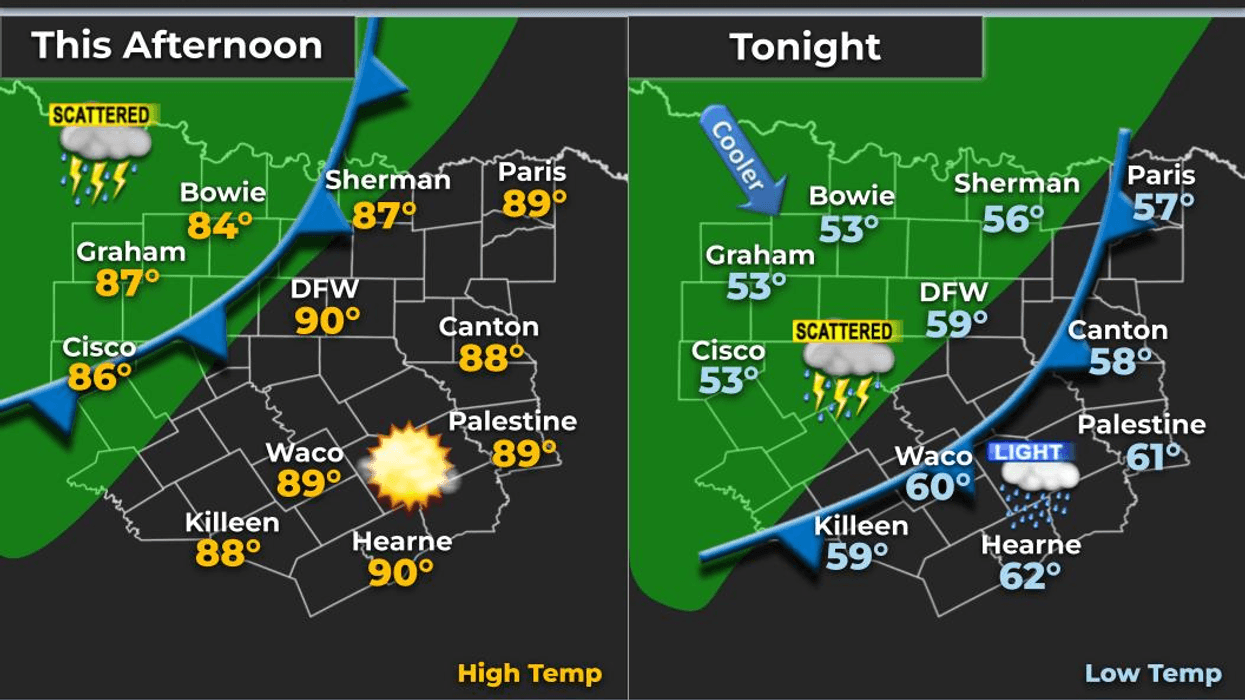
I've been tracking a strong cold front for several days, and it's finally arriving this evening! Get ready for a dramatic change in our weather, with much cooler temperatures moving into North Texas. Some of you may even get a little rain before the day is over.
We're starting this morning with very mild temperatures well into the 70s, along with low clouds streaming in from the south.
**RAIN CHANCES THIS MORNING**
Radar continues to show showers, especially northwest of the Dallas-Fort Worth area. This activity will gradually move east-northeast, and a few lucky folks across our northern counties could pick up some rainfall. Areas near Montague and Grayson counties may have the best opportunity, with showers potentially reaching as far east as Fannin and Hunt counties.
Unfortunately, not everyone will see rain, but keep an eye on the radar throughout the morning.
**STRONG COLD FRONT ARRIVES THIS EVENING**
The cold front is moving into the Texas Panhandle right now, and it should reach North Texas this evening.
Another round of showers and thunderstorms is expected to develop along the front, with a line of storms moving southeast across the region. Most of the data I've been reviewing suggests the line may weaken before reaching Fort Worth and Denton. However, I have a feeling it could hold together a little better than expected and bring at least some rainfall to portions of North Texas.
As the front moves through, winds will shift to the north and become quite gusty, with gusts around 30 mph overnight. Some light drizzle could linger into early Friday morning.
**A HUGE TEMPERATURE DROP!**
Temperatures approaching 90 degrees today will be replaced by much cooler conditions overnight.
By early Friday morning, most locations should fall into the mid to upper 40s. High temperatures Friday will struggle to reach 60 degrees in many areas as clouds hang around throughout the day.
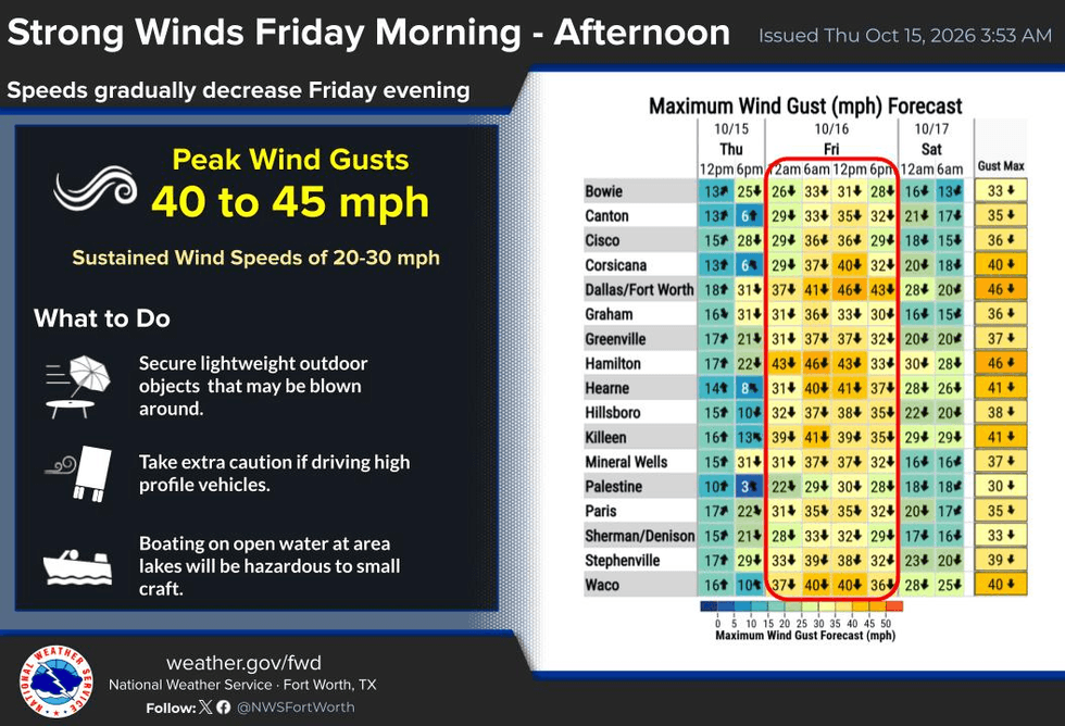
If the sun manages to break through, temperatures could climb a little higher. Otherwise, expect plenty of 50s, with north winds gusting as high as 40 mph.
Those strong winds will make it feel even colder, with wind chills remaining in the 40s for much of Friday.
Time to pull out those sweaters and jackets!
**GREAT WEATHER FOR THE STATE FAIR THIS WEEKEND!**
The good news is that the weekend is shaping up nicely!
- **Saturday morning:** Temperatures in the 40s, followed by afternoon highs in the mid-60s.- **Sunday:** A little warmer, with highs in the upper 60s to near 70 degrees.
A gradual warm-up will continue into next week, and we're not tracking another significant rain chance just yet.
I'll be monitoring the weather throughout the day and will head into KRLD if necessary. At this point, I don't anticipate needing to make that trip, but I'll continue watching developments closely.
**THE BIG WEATHER STORY: MUCH COOLER WEATHER IS ON THE WAY!**
North Texas, enjoy the warmth while it lasts today because sweater weather is about to make a comeback!
I hope everyone has a fantastic Thursday. As always, I'll keep you updated on the latest weather developments.
And remember: Enjoy the weather when you can. It's the only weather you've got!
Please LIKE and SHARE this forecast with your friends and family so everyone can stay informed about the big weather change headed our way.
7-Day Headlines:
- DFW Airport hit 93 degrees on Wednesday
- Last warm day for a while; Cold front on the way
- Lucky ones will see rain today
- VERY windy and cool on Friday; Gusts to 45 mph
- Light wind this weekend, remaining cool
- Great weekend to hit the State Fair of Texas
- Download our AUDACY app! Listen to KRLD LIVE at home or at work
Almanac:
- Yest Rain: 0.00”; Yest High: 93; Low: 79
- Today’s Averages: High: 79; Low: 57
- Record high: 95 (2015); Record low 41 (2018)
- October rain: 3.84” ”; Surplus: 2.15”
- 2026 Rain: 26.62”; Snow: 2.4”; Deficit: <2.34”>
- Sunrise: 7:33am; Sunset: 6:54pm
Forecast:
Thursday: Morning clouds, scattered showers north and west of DFW. Becoming partly cloudy, humid, and windy. Another wave of showers and storms late this afternoon and evening along the cold front. High: Upper 80s. Wind: South 5-10 mph.
Thursday night: Cloudy, windy, with scattered showers and storms before midnight. Windy and MUCH cooler! Low: Low to mid 50s. Wind: North 15-25, G30 mph.
Friday: Starting off cloudy and chilly. Decreasing clouds during the afternoon. VERY WINDY. High: Low to mid 60s. Wind: North 20-30, G45 mph.
Saturday: Sunny and cool. Lows: Mid to upper 40s; Highs: Mid 60s.
Sunday: Sunny, continued cool. Lows: 46-52; Highs: Near 70.
Monday: Sunny and perfect. High: Mid 70s.
Tuesday: Mostly sunny, continued nice. High: Upper 70s.
Wednesday: More of the same. Mostly sunny and warmer. High: Low 80s.
LISTEN on the Audacy App
Tell your Smart Speaker to "PLAY 1080 KRLD"
Sign Up to receive our KRLD Insider Newsletter for more news
Follow us on Facebook | Twitter | Instagram | YouTube